Lockport (Illinois)
| Lockport | ||
|---|---|---|
| Nickname : The city that made Chicago famous | ||
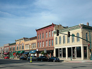
 In the center of Lockport |
||
| Location in Illinois | ||
|
|
||
| Basic data | ||
| Foundation : | 1830 (settled) 1853 (incorporated) |
|
| State : | United States | |
| State : | Illinois | |
| County : | Will County | |
| Coordinates : | 41 ° 35 ′ N , 88 ° 3 ′ W | |
| Time zone : | Central ( UTC − 6 / −5 ) | |
|
Inhabitants : - Metropolitan Area : |
24,839 (status: 2010) 9,461,105 (status: 2010) |
|
| Population density : | 828 inhabitants per km 2 | |
| Area : | 30 km 2 (approx. 12 mi 2 ) | |
| Height : | 181 m | |
| Postcodes : | 60441, 60446, 60491 | |
| Area code : | +1 779 815 | |
| FIPS : | 17-44225 | |
| GNIS ID : | 412473 | |
| Website : | www.cityoflockport.net | |
| Mayor : | Steven quarrel | |
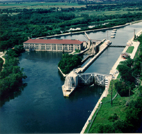
 Lockport lock |
||
Lockport is a city (with a status of " City ") in Will County of the US state of Illinois . In 2010 Lockport had 24,839 residents.
Lockport is part of the Chicago metropolitan area .
geography
Lockport is in the southwest suburbs of Chicago . On the western edge of the city is the Chicago Sanitary and Ship Canal, the most important part of the Illinois Waterway, as well as the parallel Des Plaines River , one of the two headwaters of the Illinois River that flows into the Mississippi .
The geographical coordinates of Lockport are 41 ° 35'22 "north latitude and 88 ° 03'28" west longitude. The urban area extends over an area of 30 km². The western part of Lockport is in Lockport Township , the eastern part in Homer Township .
Neighboring towns to Lockport are Lemont (12 km northeast), Homer Glen (10 km east), New Lenox (15 km southeast), Ingalls Park (9 km south), Joliet (8 km south southwest), Fairmont and Crest Hill (on the southwestern city limits) and Romeoville (8.4 km north-northwest).
Downtown Chicago is 35 miles to the northeast, Rockford is 100 miles to the northwest, Wisconsin's capital Madison is also 252 miles to the northwest, and Milwaukee is 180 miles to the north.
traffic
Interstate 355 , the outer southwest bypass of the greater Chicago area, runs along the eastern outskirts of Lockport . Illinois State Routes 7 and 171 intersect downtown . All other roads are subordinate routes as well as inner-city connecting roads.
With the Heritage Corridor , a line of METRA runs through the center of Lockport , a local transport system in the greater Chicago area comparable to a German S-Bahn. There is a METRA stop within the city.
The O'Hare International Airport of Chicago is located 58 km north-northeast of Lockport.
population
According to the 2010 census , Lockport had 24,839 people in 8,857 households. The population density was 828 inhabitants per square kilometer. Statistically, there were 2.79 people in each of the 8,857 households.
The racial the population was composed of 93.6 percent white, 1.4 percent African American, 0.1 percent Native American, 1.3 percent Asian and 2.1 percent from other ethnic groups; 1.4 percent were descended from two or more races. Hispanic or Latino of any race was 8.2 percent of the population.
29.0 percent of the population were under 18 years old, 62.2 percent were between 18 and 64 and 8.8 percent were 65 years or older. 50.7 percent of the population were female.
The average annual income for a household was 77,220 USD . The per capita income was $ 31,143. 4.3 percent of the population lived below the poverty line.
Individual evidence
- ↑ City of Lockport - City Council.Retrieved September 16, 2014
- ↑ a b American Fact Finder. Retrieved September 16, 2014
- ↑ Distance information according to Google Maps. Accessed on September 16, 2014

