
Munsterstrasse (Dortmund)
| Munsterstrasse | |
|---|---|
|
|
|
 |
|
| Münsterstrasse with Saalbau Fredenbaum and tram 1913 | |
| Basic data | |
| place | Dortmund |
| District | North city |
| Connecting roads | Evinger Strasse, Lindenhorster Strasse, Burgtor, |
| Cross streets | Steinstrasse, Malinckrodtstrasse, Haydnstrasse, Lortzingstrasse, Eberstrasse |
| Places | Freiherr-vom-Stein-Platz , Hackländer Platz |
| U41 | Fredenbaum, Immermannstrasse / Clinic Center, Lortzingstrasse, Münsterstrasse, Leopoldstrasse |
| use | |
| User groups | local residents |
| Road design | Main road / shopping street |
| Technical specifications | |
| Street length | 2.5 |
The Münsterstraße is originally an arterial road in the north of Dortmund and one of the oldest and historically most important streets in Dortmund . It runs for about 2.5 km between the former city fortifications, the castle gate and the historical border of the free imperial city at Fredenbaumpark . Today it is partially expanded as a four-lane federal highway 54 . Other parts are traffic-calmed or pedestrian zone after the main road has been re - routed .
Location and infrastructure

Münsterstrasse begins at the northern end of Dortmund city center at Freiherr-vom-Stein-Platz as an extension of the Burgtor street. Up to Mallinckrodtstrasse it is a pedestrianized shopping street on the square in front of the Josefkirche. Further out of town towards the north, it becomes part of the four-lane federal highway 54 until its end at the fork in Evinger Straße and Lindenhorster Straße.In the fork there is still a small part of the old Münsterstraße in front of the Fredenbaum stop of the U41 light rail line , which with the stops Immermannstraße and Lortzingstraße runs between the directional lanes of Münsterstraße. In the further course towards the city center, the line will then run underground with the Münsterstraße underground station. The development in the area of the federal road is mixed with apartment buildings and commercial enterprises . Further out of town are the North Clinic Center , the Museum of Natural History and a pumping station between extensive green spaces .
In its southern part as a shopping street, there are around 150 shops, smaller shops and restaurants for local supplies for the population. There is hardly any commercial space . With the exception of the space in front of the Josefkirche created by bollards, it can be used for car traffic with separation from pedestrian traffic, divided into two sub-areas. The development that encompasses the street is closed and, with a few exceptions, has four floors. The Eisengießer fountain is located in the area of Freiherr-vom-Stein-Platz .
According to data from 2012, the traffic load on Münsterstrasse in the B 54 area is on average 27,100 cars and 1,200 trucks per day with considerable emissions . In 2005, for example, the limit values for fine dust were exceeded eight times.
history
prehistory
Already in Roman times there was next to Munda Castle in Trutmania, today's Dortmund, a very important trunk road (Wißstraße, Brugghestrate ) leading from Frankfurt am Main via Siegen and Herdecke to Münster and further to northern Germany, as well as a crossroads with the pre-Roman road to the south -Germanic times from Hellweg . On his second campaign against the Saxons , Charlemagne built a royal palace at the castle in 775 . Individual finds and documents suggest that the castle and the Palatinate were located at the northern end of today's Brückstrasse / corner of Burgtor next to the road to Münster. With the construction of the first city fortifications in 1200, the Burgtor was built on the northern city limits as a passage for this important arterial road and the beginning of today's Münsterstraße was laid.
In the High Middle Ages , Münsterstrasse was an important Hanseatic trade route. It led via Lünen , Werne in the course of today's B54 Münsterstraße (Dortmund), Evinger Straße, Münsterstraße (Werne), Westfalenstraße (Münster) to Münster, from where there were connections to the North Sea and Baltic Sea ports. As a result of its convenient location, Dortmund became an important trading center and experienced an economic boom. With the Great Dortmund Feud and the Thirty Years War the decline came and Dortmund sank to the level of a small agricultural town, so that the trade routes lost their importance. Around 1750 Münsterstrasse was Postweg. Until 1835 there was the border crossing between the free city of Dortmund and the county of Mark at its northern end , from this barrier the Dortmund city freedom began , from which the name Fredenbaum was derived. On maps from 1804, there is only some development there on the western side along Münsterstrasse
industrialization


The construction of the train station on the city wall at the Burgtor by the Cologne-Mindener Eisenbahn-Gesellschaft in 1847 made the medieval arterial road an attractive residential and commercial street and in the following years Dortmund's northern city developed along Münsterstrasse. As evidenced by maps, at this time Münsterstrasse split into Lindenhorster Strasse and the Chaussee to Lünen, later Evinger Strasse, at the level of the Fredenbaum restaurant. With the founding of the coal mine Minister Stein in 1856 on the Chaussee to Lünen, and the coal mine Fürst Hardenberg in 1872 on the Lindenhorster Straße, the street gained additional industrial importance and along the Münsterstraße residential quarters and suppliers such as the sawmill Kummer built in 1868 were built .
On June 1, 1881, the Berlin contractor opened Georg Soenderop the first horse-drawn tram line of the Dortmunder streetcar AG from Steinplatz on the Münsterstraße for Fred tree erected at the northern end of Münsterstraße a tram depot for 48 horses. A short time later, the initially single-track line was extended to two tracks. The electrification took place in 1894 by the Dortmund tram company. From 1888 to 1890, a large hall was built in place of the Fredenbaum restaurant on Münsterstrasse and the surrounding Westerholz forest was redesigned into Fredenbaumpark by 1906. From 1911, the first Dortmund airfield developed north of it and in 1912 the Lunapark Fredenbaum was opened at the Saalbau, which was converted into the amusement park Upper Bavaria , an amusement park based on the Berlin Lunapark . In the middle course, the Josefgemeinde was founded in 1891 and a secondary school was built next to the sawmill in 1906. At around the same time , an entertainment district with beer and festival halls , variety theaters and brothels was built at the southern end of Münsterstrasse around Steinplatz , which was laid out in 1890 by the city architect Brandhoff , supported by the establishment of the nearby Dortmund slaughterhouse in 1885 .
World wars
The first railway depot was abandoned by 1916 and the Immermannstrasse depot was built opposite . In 1917 Concordia Electrizitäts-AG (CEAG) built a new branch opposite on Münsterstrasse. The First World War and the Great Depression as well as the occupation of the Ruhr with its strikes meant a turning point for life on Münsterstrasse during the Weimar Republic . Many amusement establishments had to close and mostly political meetings were held in the hall. For example, the last great democratic rally in Dortmund before the seizure of power by the National Socialists, who on 26 February 1933, the motto Volksrecht breaks Mr. Right with the Social Democratic Reichstag deputies and later Mayor Fritz Henßler and the deposed by the Nazis provincial government of Arnsberg, Max King took place . The hall building and the Lunapark were closed in 1940 after a demolition order and fell into disrepair. During the Allied bombing raids on Dortmund in World War II , large parts of Münsterstrasse were destroyed from 1943 onwards. Remnants of the aquarium's building remained until 1958.
post war period
In 1947, the city council decided to reorganize the entire urban area and to loosen up the structure and restore it. A new road network was also to be created in the north-south course. As a result of the reconstruction , there were a number of changes on Münsterstrasse in the years that followed. In 1951, the United Electricity Works Westphalia (VEW) built a switching station for the local grid supply and a pumping station for the piped watercourses Evinger Bach and Aalbach on Münsterstraße . Some areas of the Fredenbaum were almost constantly under water due to subsidence . In 1955 the Joseph Church was rebuilt. In the same year, an urban traffic education area was created in the Fredenbaumpark. By 1968, the Dortmund municipal clinics built an accident clinic on the site of the former Tivoli and Villa Wiskott on Münsterstrasse. The inauguration of the new Fredenbaum adventure playground followed in 1975. Opposite the city of Dortmund built the new natural history museum which opened on May 24th, 1980.
With the demolition of the slaughterhouse, the routes of the B 54 and the light rail could be relocated to Leopoldstrasse. As part of this comprehensive transport infrastructure measure, the inauguration of the main tram line I also took place on June 2, 1984 with the tunnel construction under Münsterstrasse and the subway station of the same name that began on October 22, 1969. As part of the urban renewal program Nordstadt program from 1986 to 1991, the southern part of Münsterstrasse was reduced to a traffic-calmed shopping street, the party mile was torn down and the Steinplatz was renovated. The Eisengießer fountain was rebuilt according to old construction drawings. In 1999, the CEAG site was converted into residential development as part of the Emscher Park International Building Exhibition and on September 29, 2001, the "Big Tipi" was inaugurated on the Fredenbaum adventure playground. As part of the EU joint initiative URBAN II , various urban development projects were implemented from 2005 to 2008 in the Münsterstrasse area by the NRW urban renewal and urban development company. For example, additional educational facilities have been created on the Fredenbaum Big Tipi adventure world, which is around 25,000 m² in size , or the Münsterstrasse trade association has been initiated.
today

The residential structure along Münsterstrasse is multicultural . Gastronomy from various cultures as well as grocery stores have settled in the pedestrian zone, and there are also trendy bars. The Münsterstrasse Festival has been held annually as part of the International Week for 20 years .
Important buildings (selection)
- Eisengießer-Brunnen, Freiherr-vom-Stein-Platz, built in 1906 with donations. Rebuilt in 1990 according to old plans.
- Catholic parish church St. Joseph, Munsterstrasse corner Heroldstrasse, rebuilt in 1955.
- Helmholtz-Gymnasium , Münsterstrasse 122, built in 1907 as Hindenburg-Realgymnasium according to plans by Stadtbauinspektor Uhlig, is now a listed building .
- Residential and commercial building, Münsterstrasse 161, listed.
- CEAG Verwaltung, Münsterstrasse 231, built in 1917. The building was destroyed by bombs in 1943 but rebuilt shortly after the war. It is now a listed building and was converted into a residential building in 1990.
- Clinic Center North , Münsterstrasse 240, built in 1968, expanded several times since then.
- Museum of Natural History (Dortmund) , Münsterstrasse 271, built in 1980.
- Saalbau Fredenbaum, built in 1890, destroyed from 1940.

Münsterstraße with the Helmholtz high school

Münsterstrasse with the former CEAG administration. Listed and since 1999 residential building

Münsterstrasse with a listed residential building

Former tram depot

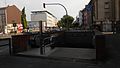
Münsterstrasse stop

Big teepee

Freiherr-vom Stein-Platz with iron foundry fountain

Clinic Center North

Museum of Natural Science
U-Bahn Münsterstrasse next to Helmholtz-Gymnasium


.jpg)
Public perception and reception
- From August 15 to October 25, 2015, the city history exhibition The Munsterstrasse Dortmund's Colorful Pavement took place in the Museum for Art and Cultural History Dortmund .
- Münsterstrasse is the location and subject of touristic tours.
- As a social hotspot, Münsterstrasse is often the subject of media reports and political discourse in the city council, as well as the location of an abundance of projects. On the other hand, residents complain about the predominantly negative reporting, while the positive is mostly concealed.
- The Dortmund carnival parade regularly takes place on Shrove Monday on Münsterstrasse.
- Since 2005, the trade association Interest Group Münsterstraße e. V., financially supported by the project funding activities Münsterstrasse of the city of Dortmund, tradespeople in Münsterstrasse under the slogan "Dortmunds lively pavement".
Historical maps
- Romberg-Brünninghausen: Dortmund - city map . 1810 ( deutsche-digitale-bibliothek.de ).
- vd Berken, surveying inspector - Arnsberg government: Dortmund - city map 1: 10,000 . Pulchra pressure; CG Blanckertz, Düsseldorf 1906 ( deutsche-digitale-bibliothek.de ).
- Oberpräsidium Münster (Ed.): City map with drawn airfields 1: 15,000 . W. Gröschen, 1929 ( deutsche-digitale-bibliothek.de ).
Web links
Individual evidence
- ↑ Speaker of the Cultures Analysis . In: Route der Menschenrechte Dortmund city center . University of Applied Sciences Dortmund, July 4, 2012 ( routedermenschenrechte.de [PDF]).
- ↑ Michael, Andreas Beilein, Achim Tack: Business street space design Documentation of street element recordings . Ed .: German Seminar for Urban Development and Economy. 2007, p. 10 ff . ( irbnet.de [PDF]).
- ↑ a b Holger Mrosek, Tobias Zeller: Life in Dortmund . Ed .: Asta Dortmund. 2nd Edition. March 2001, p. 16 ( asta-dortmund.de [PDF]).
- ^ F. Weiser, D. Lesch, A. Sillus, N. Sauermann: Traffic report for the Dortmund dialogue on port traffic . Ed .: traffic department of the Dortmund municipal utilities. February 2015, p. 6 ( dialoggestalter.de [PDF]).
- ↑ Fine dust pollution in Dortmund: Only a targeted and comprehensive traffic concept can help the city . In: BUND (ed.): Press information . April 1, 2005, p. 6 ( bund-dortmund.de [PDF]).
- ^ Dirk Sondermann: Emschersagen. From the mouth to the source. Henselowsky Boschmann Verlag, Bottrop 2006, ISBN 3-922750-66-4 ( legendhaftes-ruhrgebiet.de ).
- ^ A b Hans-Claus Poeschel: Old highways in the middle Westphalian bay . Geographical Commission for Westphalia, Münster 1968, p. 131 ff. u. Fig. 280 ff . ( lwl.org [PDF]).
- ↑ a b Beginnings - 17th century. (No longer available online.) In: Stadtgeschichte. City of Dortmund, archived from the original on May 20, 2018 ; accessed on April 25, 2018 . Info: The archive link was inserted automatically and has not yet been checked. Please check the original and archive link according to the instructions and then remove this notice.
- ↑ a b c Hubert Nagusch: Fredenbaum. City of Dortmund, accessed April 20, 2018 .
- ^ A b Ernst Steinberg: Beginning of the industrialization of Dortmund . In: Bielefeld University (Hrsg.): Didactic material collection for history lessons . 2005 ( uni-bielefeld.de [PDF]).
- ↑ a b The early years of the Hindenburg-Realgymnasium (today Helmholtz-Gymnasium). In: Nordstadtblogger. Kulturort Depot, accessed on April 19, 2018 .
- ↑ a b c Klaus Winter: The Eisengießer fountain donated by the citizens on Freiherr-vom-Stein-Platz. In: Nordstadtblogger. Kulturort Depot, accessed on April 19, 2018 .
- ^ Museum for Art and Cultural History (ed.): The Münsterstrasse Dortmund's colorful pavement . Dortmund 2015, p. 2 ( dortmund.de [PDF]). The Münsterstrasse Dortmund's colorful pavement ( memento of the original from April 20, 2018 in the Internet Archive ) Info: The archive link was automatically inserted and not yet checked. Please check the original and archive link according to the instructions and then remove this notice.
- ^ History of Dortmund 1877-1900. Historical Association Dortmund, accessed on April 19, 2018 .
- ↑ a b c d Hubert Nagusch: The history of the Dortmund north city. City of Dortmund, accessed on April 22, 2018 .
- ↑ Industrial population and "social question". (No longer available online.) In: Stadtgeschichte. City of Dortmund, archived from the original on April 28, 2018 ; accessed on April 25, 2018 . Info: The archive link was inserted automatically and has not yet been checked. Please check the original and archive link according to the instructions and then remove this notice.
- ^ A b c Klaus Winter: The Concordia-Elektrizitäts-AG in Dortmund - 100 years of the CEAG house. In: Nordstadtblogger. Kulturort Depot, accessed on April 19, 2018 .
- ↑ Bernhard Butzin, Raimund Pahs: Urban development 1. Post-war period Nordstadt. In: Regionalkunde Ruhrgebiet. Center for Interdisciplinary Regional Research ZEFIR, accessed on April 26, 2018 .
- ↑ Hubert Nagusch: EU community initiative URBAN II Dortmund-Nordstadt. Agiplan, accessed April 26, 2018 .
- ↑ That was the Münsterstrasse Festival. In: Ruhr news. July 1, 2017, accessed April 27, 2018 .
- ↑ Münsterstrasse Festival. City of Dortmund, accessed on April 27, 2018 .
- ^ Gunther Seibold: Catholic parish church St. Joseph. In: Kirchenbau.de. Retrieved April 19, 2018 .
- ↑ City history exhibition on Münsterstrasse. City of Dortmund, August 25, 2015, accessed on April 19, 2018 .
- ^ The Münsterstrasse. In: Dortmund Tourism. Retrieved April 20, 2018 .
- ^ Peter Bandermann: How a homeowner experiences Münsterstrasse. In: Ruhr news . March 26, 2016, accessed April 27, 2018 .
- ↑ Police prevent escalation after cell phone theft with large numbers. In: Focus . May 29, 2017. Retrieved April 27, 2018 .
- ↑ Template overview of the council resolutions on Nordstadt and their current implementation. City of Dortmund, November 30, 2011, accessed April 27, 2018 .
- ↑ Reiner Staubach, Tülin Kabis-Staubach, Thomas Martha: Topography of engagement in Dortmund's northern city. RHTW Aachen - Planerladen eV, July 2008, accessed on April 27, 2018 .
- ↑ Felix Huesmann bento: Why I love my no-go area. Retrieved November 30, 2019 .
- ↑ Rose Monday procession. Festival committee Dortmund Carnival e. V., accessed April 27, 2018 .
- ↑ All information about the Carnival Monday procession in Dortmund. In: Focus. February 11, 2018, accessed April 27, 2018 .
- ↑ Appendix to the 2015 Annual Report. In: StadtbezirksMarketing Dortmund eV Annual Report 2015. City of Dortmund, accessed on April 27, 2018 .
Coordinates: 51 ° 31 '50 " N , 7 ° 27' 28" E