Melville Island (Canada)
| Melville Island Île Melville |
|
|---|---|
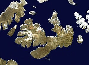
| Satellite image of the island | |
| Waters | Arctic Ocean |
| Archipelago | Queen Elizabeth Islands |
| Geographical location | 75 ° 30 ′ N , 111 ° 30 ′ W |
| length | 340 km |
| width | 120 km |
| surface | 42,149 km² |
| Highest elevation | (unnamed) 776 m |
| Residents | uninhabited |
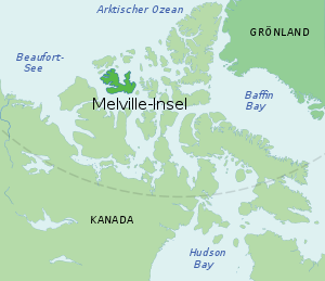
| Map of the island | |
Melville Island (English) or Île Melville (French) is an uninhabited island in the Canadian Arctic Archipelago and belongs to the Northwest Territories west of the 110th degree of longitudeand east of it to the Canadian territory of Nunavut .
geography
The island is about 340 km long and 50 to 120 km wide. With an area of 42,149 km² (according to other sources 37,680 km²), it is the fourth largest of the Queen Elizabeth Islands and ranks 33rd in the list of the largest islands in the world . It is irregularly shaped. Large peninsulas are Sabine Peninsula in the north and Dundas Peninsula in the south. The island is relatively hilly and at its highest point in the Blue Hills in the southwest is 776 m high. Inside there are smaller areas covered by ice. The permafrost reached a depth of 535 m at the end of the 20th century.
From the Victoria Island in the South Melville Iceland is by the Viscount Melville Sound separate from the Banks Island in the southwest by the McClure Strait , from Eglinton Iceland in the west by the Kellett Strait from Prince Patrick Iceland in the north-west by the Fitzwilliam Strait , from Mackenzie King Island in the north through Hazen Strait , from Lougheed Island , Cameron Island , Île Vanier , Massey , Alexander and Bathurst Island in the northeast through the Byam Martin Channel and from Byam Martin Island in the east through the Byam Channel .
history
Tent rings near Bridport Inlet and Liddon Gulf prove that people of the Dorset and pre-Dorset cultures visited the island seasonally. Other archaeological finds on the Liddon Gulf are attributed to the Thule culture . Apparently groups of hunters regularly visited the island 3,000 to 500 years ago.
From a European perspective, the island was discovered on September 1, 1819 by the British explorer Sir William Parry , who landed near Point Ross the following day. From September 26th he spent the winter with his ships HMS Griper HMS Hecla in Winter Harbor, a bay in the south of the island. Parry named the island after Robert Dundas , the 2nd Viscount Melville. In 1851 Sir Francis Leopold McClintock explored the south coast of the island now called Melville Island in search of the missing Franklin expedition . In 1906 Joseph-Elzéar Bernier went ashore at Arctic Point and took possession of the island for Canada.
In search of oil and gas in the Canadian Arctic, the first test well was carried out in 1961 near Winter Harbor. In 1969 Panarctic Oils found large natural gas deposits (98.5 billion m³) for the first time at Drake Point on the Sabine Peninsula. A second large natural gas field (Hecla) was found 50 km to the west at Hecla and Griper Bay. On October 30, 1974, Panarctic Oils Flight 416 had an accident while approaching Rea Point Airfield . 30 passengers and two of the four crew members were killed.
Flora and fauna
The vegetation is sparse. Arctic wolves and musk ox live on the island in large numbers, but only a few caribou .
Individual evidence
- ↑ The Atlas of Canada - Sea Islands ( Memento from October 6, 2012 in the Internet Archive ) (English)
- ^ Melville Island ( English, French ) In: The Canadian Encyclopedia . Retrieved August 21, 2016.
- ↑ a b c R. L. Christie: Introduction . In: RL Christie and NJ McMillan (Eds.): The Geology of Melville Island, Arctic Canada . Geological Survey of Canada, Bulletin 450, 1993, pp. 7-11. doi : 10.4095 / 194013
- ^ William James Mills: Exploring Polar Frontiers - A Historical Encyclopedia . tape 2 . ABC-CLIO, 2003, ISBN 1-57607-422-6 , pp. 422–423 (English, limited preview in Google Book Search).
- ^ A Guide to Oil and Gas Exploration and Potential . Northern Oil and Gas Directorate, Indian and Northern Affairs Canada, 1995, ISBN 0-662-23120-1 , p. 79 (English).
- ↑ Aircraft accident report in the Aviation Safety Network (English)


