
Declination (geography)
Declination (also: declination or local declination ; engl .: magnetic declination or variation ) is the - small - angle between the direction of the horizontal component of the field lines of the earth's magnetic field and the geographic north direction , which especially in the navigation with the magnetic compass to be considered must.

The local differences in the angle of declination are mainly determined by the irregularities of the earth's magnetic field, and in the vicinity of the poles also by the different positions of the geographic and magnetic poles.
Earth's magnetic field and declination
Geographical and magnetic pole
The geographic north pole is defined by the earth's axis of rotation . It is one of the two points where the earth's axis passes through the earth's surface.
The Arctic magnetic pole is defined as that region of the earth's surface where the earth's magnetic field enters the earth perpendicularly. It is located - determined by the position and shape of the Earth's magnetic field - in the Canadian Arctic , was about 800 km from the geographic North Pole in 2005 and changes its position by several tens of kilometers every year.
(According to the magnetic polarity it is a south pole, see compass .)
A compass located between the magnetic and the geographical pole does not point to the geographical pole, but in the opposite direction to the magnetic pole - the declination in this purely geometrically determined extreme case is 180 °. However, it is significantly lower in areas less close to the poles.
Irregularities in the earth's magnetic field

It is often assumed that the different positions of the magnetic and geographic poles are generally the reason why a compass does not point exactly to the geographic north pole. A look at a declination map shows that this different position cannot be the actual cause: the Arctic magnetic pole is currently at about 133 ° west longitude. Since the magnetic and geographic poles are in the same direction for all locations on the meridian 133 ° West, the declination according to this argument should be zero. In fact, on this meridian at the equator and in moderate northern latitudes (in the Pacific off the North American coast) it is between ten and twenty degrees and increases considerably towards the pole.
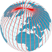
This is due to irregularities in the shape of the earth's magnetic field, as can be seen in the adjacent figure. A magnetic meridian is shown as a red line , the course of which follows the direction indicated by compasses. The angle between a magnetic meridian and the geographic meridians shown in blue and running exactly in north-south direction is the local declination. As can be seen, the magnetic meridian shown intersects the longitude 133 ° west running in the center of the image at an angle of a good ten degrees and therefore does not point towards the magnetic pole. In its further course it initially aims east of the magnetic pole, but then ends in it after a curve. So a traveler who always follows the direction indicated by his compass will ultimately reach the magnetic pole, but generally on a curved path. Similar conditions also apply to the other regions of the earth's magnetic field.
An observer in German-speaking countries can determine that the local magnetic meridians aim in a direction just east of the geographic pole, so that the declination here is a few degrees east. In their further course, the meridians initially follow this direction almost in a straight line and only pivot around in the direction of the magnetic pole after passing the geographic pole.
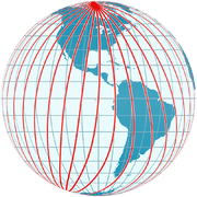
The following diagrams show the distribution of the horizontal component of the earth's magnetic field, which is decisive for the alignment of compasses. Magnetic meridians are shown in red, which everywhere follow the direction indicated by compasses.

View at 0 ° longitude

View at 90 ° longitude

View of 180 ° longitude
View at −90 ° longitude
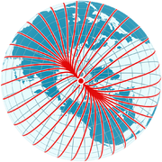
View of the arctic magnetic pole

View of the Antarctic magnetic pole
View of Europe


Earth's magnetic field and poles
“People would probably be far less interested in magnetic poles if they knew that their location doesn't determine which way a compass needle is pointing. The real meaning of magnetic poles is mainly that a compass is useless around them. "


The mistaken expectation that the compass needle must point directly to the earth's magnetic pole is favored by the fact that both the poles of a conventional magnet and the poles of the earth's magnetic field are referred to by the same term “pole” despite their very different definition.
- The poles of a simple magnet such as a bar magnet are imaginary points within the magnet that have been chosen so that the external magnetic field can be described as closely as possible by imaginary field lines that emanate from one pole as a field source and the other as a field sink immerse. (Such individual poles do not really exist, but they can be used for an approximate mathematical description of the field.) The field of such magnets is essentially determined by the position and strength of these poles.
- The poles of the earth's magnetic field, on the other hand, are defined as those places on the earth's surface where the magnetic field is perpendicular. They are not directly related to the generation and shape of the earth's magnetic field - they are a consequence of the shape of the field, which is not generated on the surface, but in an extensive region of the outer core of the earth.
The external magnetic field of the earth can be thought of as approximately generated by a bar magnet inside the earth. If this equivalent field is to match the real field as well as possible, this imaginary bar magnet in the center of the earth would have to be very short. Its poles would be thousands of kilometers below the poles of the earth's magnetic field, which by definition are on the surface. This consideration underlines that the poles of the earth's magnetic field are not centers of attraction like the poles of a bar magnet; they are just those places on the surface where the magnetic field happens to be perpendicular. As this substitute image already suggests, the real field lines of the earth's magnetic field by no means run from the Antarctic to the Arctic magnetic pole. Rather, they arise deep in the earth's interior of the southern hemisphere, emerge from the earth's surface at all locations south of the magnetic equator , in order to re-enter the earth's surface distributed over the northern hemisphere and to dive deep into the earth's interior (see also → inclination and → magnetic meridian ).
The alignment of a compass is therefore not controlled by the magnetic poles, but solely by the direction of the local magnetic field. The direction of the local magnetic field on the earth's surface is in turn determined by the uneven distribution of the field sources in the earth's interior and not by the position of the poles. Although the compass needle generally points in a northerly direction because of the dipole- like shape of the total field, the local direction of the field lines of the earth's magnetic field deviates from the direction to the arctic magnetic pole over large parts of the earth's surface.
history

A first observation of the declination was probably made around the year 720 by the Chinese astronomer Yi Xing . From the years 720 to 1280, at least nine declination determinations can be found in Chinese sources. European sources suggest that the declination was generally known in Europe since the early 1400s. The first European measurement of the declination is probably an observation made by Georg Hartmann around 1510 in Rome.
Gerhard Mercator concluded from observations of the declination in 1546 that the point to which the magnetic needle points is not in the sky (i.e. not identical with the Pole Star, as is sometimes assumed), but lies on the earth. In 1600, William Gilbert described the earth itself as a large magnet, the poles of which attract the ends of the magnetic needles.
Portuguese sailors developed methods to determine the declination at sea and thus to be able to use the compass to determine the location. João de Castro, for example, determined a total of 43 declination values between 1538 and 1541 on his travels to East India, along the Indian west coast and in the Red Sea - the first attempt to map declination worldwide. Edmond Halley's two ship voyages through the North and South Atlantic 1698-1700 were the first sea voyages that were undertaken for purely scientific purposes and resulted in a first declination map for the Atlantic in 1702 (Halley's lines).
Variability of the declination
Internal and external causes

The main part of the earth's magnetic field is generated by convection currents in the earth's core . These processes are subject to very, very slow changes, which also result in slow changes in declination, the so-called secular changes. These take place on time scales from a few years to a few million years. In Europe they are currently mainly expressed in the slow west drift of the isogons by more than 20 km per year. The resulting change in declination can only be approximately predicted for a few years.
For Munich the declination was almost 17 ° West around 1841 and has been steadily increasing to the east since then. It reached 0 ° at the end of the 1980s, is currently (2014) a good 3 ° East and increases by 7.5 arc minutes every year .
Smaller parts of the earth's magnetic field originate from the magnetosphere and the electrically conductive E-layer of the ionosphere . These proportions are subject to more rapid changes, on time scales ranging from a fraction of a second to a few years. Both the magnetosphere and the ionosphere interact in particular with the solar wind . Its influence fluctuates due to the earth's rotation in the daily rhythm and leads, among other things, to a slight diurnal variation of the declination.
On magnetically calm days ( Sq variation ), the daily fluctuation follows a pattern that cannot be precisely predicted in individual cases, but is on average typical. The strength of the fluctuation depends on the time of day, the season, the geographical (more precisely: magnetic) latitude and other factors. In northern latitudes, the declination typically assumes an easterly maximum around eight or nine a.m. local time , followed by a westerly extreme around 1 or 2 p.m. This is followed by a slow eastward drift in the afternoon and at night until an easterly maximum is reached again the next morning. In southern latitudes, the western maximum is in the morning and the eastern in the afternoon. The magnitude of the fluctuation is greater in summer than in winter and greater near a magnetic pole than at the equator. In Germany, the typical daily fluctuation is around four minutes of arc in winter and around eight to ten minutes of arc on hot summer days.
During a magnetic storm , the declination can vary by 30 ° and more near the poles, and up to around 2 ° in temperate latitudes.
history

The variability of the earth's magnetic field was first established by Henry Gellibrand , who in June 1634 found the declination in London to be more than 7 ° smaller than William Borough had measured it in October 1580. The investigations by Edmond Halley (including the magnetic measurements obtained on two ship voyages 1698–1700) indicated a westward drift of the earth's magnetic field. In 1722, the London watchmaker George Graham succeeded in discovering constant daily changes in the direction of the earth's magnetic field with a magnetic needle readable on 2 ′ , which could exceed 30 ′ in one day, sometimes within a few hours. He was the first to distinguish between quiet and disturbed days. In 1741 presented Olav Peter Hiorter and Anders Celsius in Uppsala a connection between magnetic storms and auroras tightly as they declination of 4 ° observed changes within 4 minutes.
John Canton demonstrated in London in 1759 that the mean movement of the needle on calm days was greater in summer (over 13 ') than in winter (less than 7'), which was the first time that a variability with an annual period was identified ( Cassini showed 1782 in Paris that it was not just a matter of temperature influence). The organized scientific investigation of the geomagnetic field began in the early 19th century with the work of Humboldt in Berlin, Arago in Paris, and Gauß and Weber (the founders of the Magnetic Association ) in Göttingen.

In German-speaking countries, the declination is currently only about one to four degrees to the east and increases annually by about six to eight angular minutes to the east. Because of its small amount, it can be ignored for many orientation tasks (e.g. hiking). In the case of higher accuracy requirements or in areas with a larger declination (e.g. in Canada, USA, South Africa and New Zealand it reaches up to 20 ° and more) it must be taken into account.
The directions with respect to true north and magnetic north can easily be converted into one another if the current local declination is known. However, care must be taken to ensure that the signs are correct. If magnetic north is west of true north, the declination is called westerly and is counted as negative ; if magnetic north is east of true north, the declination is called east and counted as positive .
A rule of thumb is: "From false to true with the true sign, from true to false with the wrong sign." The "true" direction is the geographically north-related direction (cf. correct ), the "wrong" direction is that related to magnetic north (see. ill-setting ).
If a direction related to magnetic north is to be converted into a direction related to geographic north (false → true), the declination must be added taking into account its given sign. If a course related to geographic north is to be converted into a course related to magnetic north (true → false), the declination must be added by reversing its sign.
For other methods of converting course when orienting yourself with the compass in the field, see → Hiking compass .
For details of course conversion in sea and aviation, see → Course loading .
The local declinations are shown in isogonal maps for use in navigating with the compass . (The isogons shown connect places with the same declination). The declination can be taken from such maps or from declination calculators (see web links). On official nautical charts , however, the declination representative for the area shown is always given as a numerical value. Likewise on most topographic maps .
In aviation , the declination is also referred to as variation (VAR). On aeronautical maps, it can be found in the isogons drawn in the map image.
Determination of the declination
The declination data for the above Isogen maps as well as for the above Declination calculators (see web links) usually come from mathematical magnetic field models. The data for these models come from satellite explorations as well as from worldwide measurements by geomagnetic observatories (around 200 worldwide). These models allow the declination to be determined for locations and (to a limited extent) for times when and at which no direct measurements have taken place.
Examples of such models are the International Geomagnetic Reference Field (IGRF) or the World Magnetic Model (WMM) . However, these models only describe the large-scale field strength distributions from the Earth's core. Small-scale field structures that exist in some places in the earth's crust are not taken into account. The models can therefore have localized deviations of up to a few degrees compared with the real field. Such deviations are mostly found on land, over continental margins and over deep sea mountains , ridges and trenches . In individual cases, local geological structures can cause deviations of 10 ° and more from the global model. At sea, the models usually reproduce the measurements with a scatter of about 0.5 °. Naturally, the so-called non-secular, shorter-term changes such as B. the daily rate or magnetic storms. The accuracy of the models is therefore not always given. The models are currently only fundamentally revised every five years and the time in between is covered with information on the rate of change.
If the declination is not known or only known with insufficient accuracy, it can be approximately determined for the current location by the difference between the bearing direction determined with a precise compass (i.e. its direction with respect to magnetic north) to a target as far away as possible and that otherwise (eg from a map) determined geographical direction to the bearing object is formed. The angle determined in this way not only records the declination, but possibly also the deflection due to magnetic disturbances in the immediate vicinity (see deviation). If only the declination is to be determined, it must be ensured that there is no magnetic interference in the immediate vicinity. The accuracy of the declination determined in this way naturally also depends on the accuracy of the compass used and on how the bearing was carried out.
However, the real distribution of the declination can only be determined by measurement. Suitable magnetic observatories are able to measure the declination with an accuracy of up to 5 arc seconds .
Trivia
The runway identifications of airfields are usually derived from the orbit directions related to magnetic north . The corresponding number of degrees is divided by ten and rounded to the nearest whole number. For example, a path with the identifier 04/22 runs in the direction of 40 ° (and 220 ° in the opposite direction). Due to the secular change in the declination, the reference direction magnetic north changes in the longer term and thus also the direction of the orbit related to magnetic north. It is therefore occasionally necessary to change runway IDs. So the name was, for example, runway of the Salzburg airport updated on August 23, 2012 from 16/34 to 15/33. (The local declination increases, the reference direction magnetic north drifts to the east, the number of degrees of the orbit direction counted from magnetic north over east is therefore smaller.)
Related terms
- Meridian convergence
- is the angle between true north and grid north . The grid lines of a map run parallel to the main meridian and only in this do geographical north and grid north coincide.
- Needle deviation ( grivation )
- is the angle between the grid north of a map and magnetic north . The following applies:
- Needle deviation = magnetic declination - meridian convergence.
- The signs must be observed, i.e. the directions of the deviations.
- Deviation or distraction
- is the angle between magnetic north and the real magnetic needle deflected by local interference fields.
- Inclination
- is the angle at which the field lines pass through the earth's surface.
See also
Web links
- Declination map worldwide
- ( Page no longer available , search in web archives: Declination maps for Germany from 1982 to 2012 )
- Declination map for Austria
- NOAA declination calculator
- Declination calculator of GFZ Potsdam
- Declination calculator of the University of Neuchâtel for Switzerland (including local anomalies)
- Magnetic field in the Arctic regions Comparison of the real near-pole field with a simple dipole field
- Measuring Earth's Magnetism, NASA 2014
Remarks
- ↑ While the pole defined in this way is referred to as dip pole ( dip = inclination ) in English, there is no conceptual distinction in German for the two very differently defined types of poles.
Individual evidence
- ↑ Woltman, Reinhard : Brief history and description of the bank structures on the island of Neuwerk . Langhoff, 1826 (Hamburg State and University Library, digitized version ).
- ^ JH Nelson, L. Hurwitz, DG Knapp: Magnetism of the Earth. US Department of Commerce - Coast and Geodetic Survey, Publication 40-1, United States Government Printing Office, Washington 1962, p. 5 ( PDF 7.1 MB )
- ↑ S. Macmillan, S. Maus: International Geomagnetic Reference Field - the tenth generation. Earth Planets Space, Vol. 57 (2005), 1135–1140 ( PDF 1.1 MB )
- ^ HH Howe, L. Hurwitz: Magnetic Surveys. US Department of Commerce - Coast and Geodetic Survey, Serial No. 718, 3rd ed., US Government Printing Office, Washington 1964, p. 4 ( PDF 1.2 MB ): “Very likely there would be much less popular interest in magnetic poles if it were thoroughly understood that their positions do not determine the direction taken by a compass needle. The principal real concern about magnetic poles is that a compass is useless near them. "
- ↑ a b c H.H. Howe, L. Hurwitz: Magnetic Surveys. US Department of Commerce - Coast and Geodetic Survey, Serial No. 718, 3rd ed., US Government Printing Office, Washington 1964, p. 4 ( PDF 1.2 MB )
- ^ HH Howe, L. Hurwitz: Magnetic Surveys. US Department of Commerce - Coast and Geodetic Survey, Serial No. 718, 3rd ed., United States Government Printing Office , Washington 1964, p. 3 ( PDF 1.2 MB )
- ↑ a b c R.T. Merrill, MW McElhinny: The Earth's Magnetic Field - Its History, Origin and Planetary Perspective. Academic Press Inc., London 1983, ISBN 0-12-491240-0 , pp. 5 ff. ( Google Books )
- ↑ a b W. Left: Orientation with map, compass, GPS. Delius Klasing Verlag, Bielefeld 2011, ISBN 978-3-7688-3314-1 , p. 96
- ↑ J. Untiedt: The Earth's Magnetic Field . Physics in Our Time, 4th year (1973), No. 5, 145–155, Fig. 6 ( PDF 4.0 MB )
- ^ Declination calculator GFZ Potsdam
- ^ A b c d V. Courtillot, JL Le Mouël: Time Variations of the Earth's Magnetic Field: From Daily to Secular. Annual Review of Earth and Planetary Sciences, Vol. 16, pp. 389-476 (May 1988), doi: 10.1146 / annurev.ea.16.050188.002133
- ^ HH Howe, L. Hurwitz: Magnetic Surveys. US Department of Commerce - Coast and Geodetic Survey, Serial No. 718, 3rd ed., US Government Printing Office, Washington 1964, p. 4f ( PDF 1.2 MB )
- ^ H. Kahmen: Surveying. de Gruyter, Berlin / New York 1993, ISBN 3-11-013732-1 , p. 547
- ^ W. Kahl: Navigation for expeditions, tours, trips and journeys. Orientation in the wild. Schettler publications, Hattorf am Harz 1996, ISBN 3-88953-301-9 , p. 156
- ↑ US / UK World Magnetic Model - Epoch 2010.0 - Main Field Declination (D) ( PDF 1 MB , accessed February 4, 2014)
- ↑ US / UK World Magnetic Model - Epoch 2010.0 - Annual Change Declination (D) ( PDF 1 MB , accessed on January 21, 2014)
- ^ RB Langley: Getting Your Bearings - The Magnetic Compass and GPS. GPS World, September 2003, pp. 70–80 ( PDF 0.6 MB )
- ↑ Aviation Handbook Austria / AIP Austria ( PDF 0.3 MB ( Memento of the original from February 23, 2014 in the Internet Archive ) Info: The archive link has been inserted automatically and has not yet been checked. Please check the original and archive link according to the instructions and then remove this notice . )
- ↑ 2012: Runway 16-34 is renamed to 15-33. In: salzburg.com. Retrieved June 3, 2017 .