Montealegre de Campos
| Montealegre de Campos municipality | ||
|---|---|---|
 Montealegre de Campos - town view with castle ( castillo )
|
||
| coat of arms | Map of Spain | |

|
|
|
| Basic data | ||
| Autonomous Community : |
|
|
| Province : | Valladolid | |
| Comarca : | Tierra de Campos | |
| Coordinates | 41 ° 54 ′ N , 4 ° 54 ′ W | |
| Height : | 815 msnm | |
| Area : | 33.97 km² | |
| Residents : | 109 (Jan. 1, 2019) | |
| Population density : | 3.21 inhabitants / km² | |
| Postal code : | 47816 | |
| Municipality number ( INE ): | 47092 | |
| administration | ||
| Website : | Montealegre de Campos | |
Montealegre de Campos is a town in northern Spain and a municipality ( municipio ) with 109 inhabitants (as of January 1, 2019) in the province of Valladolid in the autonomous community of Castile-Leon . The entire place with its castle ( castillo ) is recognized as a conjunto histórico-artístico .
location
Montealegre de Campos is located on a northern branch of the Montes Torozos above de Río Anguijon in the Comarca Tierra de Campos in the Castilian plateau at an altitude of about 815 m above sea level. d. M. The provincial capital Valladolid is a good 35 km (driving distance) southeast; the city of Palencia is a good 40 km to the northeast. The climate in winter is quite cold, but in summer it is warm to hot; the sparse rainfall (approx. 440 mm / year) falls throughout the year.
Population development
| year | 1842 | 1900 | 1950 | 2000 | 2016 |
| Residents | k. A. | 614 | 444 | 169 | 122 |
The population decline in the 20th century is largely due to the mechanization of agriculture and the associated loss of jobs.
economy
Field farming and viticulture have always played the most important role for the population of the region, but handicrafts and trade developed as early as the Middle Ages. In the second half of the 20th century, the tourism sector also gained greater importance.
history
In pre-Roman times the region belonged to the settlement area of the Celtic tribe of the Vaccaeans ; later came the Romans and Visigoths . In the 8th century, the area was used by the Moors invaded, but already in the 9th century Asturian-Leonese army of conquered areas north Duero back ( reconquista ) . At the end of the 10th century, the Moorish military leader Almansor temporarily wiped out the Christian successes, but in the 11th century the Kingdom of León expanded its territory again to the Duero border. After previous attempts, León finally united with the Kingdom of Castile in 1230 . However, the place experienced its heyday in the late Middle Ages and in the early modern period.
Attractions

- The Castillo de Montealegre de Campos , built in the 14th century, with its approx. 4 m thick and up to 20 m high walls is an impressive example of late medieval defense architecture. The entire system is designed largely symmetrically; It has three corner towers on a square and one on a pentagonal floor plan ( torre del homenaje ) and four round stair towers in the middle of the defensive walls ( cortinas ). On the walls of the almost square inner courtyard there were stables and storage rooms on the ground floor as well as bedrooms for the guards above.
- The Iglesia de Santa María dates from the 16th century. Its rather austere facade is accentuated by a three-part bell gable ( espadaña ) with lateral volutes and ornamental obelisks ; behind it is a bell chamber . The nave has a round arch vault with side stitch caps ; the apse is spanned by a star vault.
- The Iglesia de San Pedro is a three-aisled building from the 17th century. In its apse there is an imposing plateresque altarpiece from the 16th century with 16 painted scenes from the life of Mary and the apostle Peter .
- The small Ermita del Humilladero is located at the end of the village on the road to Valladolid. In its nave, which is spanned by a wooden roof, is now a museum on shepherd culture ( Museo del Pastor ).
- Surroundings
- The Ermita de la Virgen de las Serosas , built in the 17th century, is located in the middle of the fields.
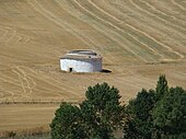
- In the fields there are also some round and square pigeon houses ( palomares ) made of clay and some stone huts ( chozos ).
Web links
- Montealegre de Campos, history and sights - photos + info (Spanish)
- Montealegre de Campos, Castillo - Photos + Info (Spanish)
Individual evidence
- ↑ Cifras oficiales de población resultantes de la revisión del Padrón municipal a 1 de enero . Population statistics from the Instituto Nacional de Estadística (population update).
- ↑ Montealegre de Campos - Map with altitude information
- ↑ Montealegre de Campos - climate tables
- ↑ Montealegre de Campos - Population development
- ↑ Montealegre de Campos - History and sights
- ↑ Montealegre de Campos - Castle
- ↑ Montealegre de Campos - Church of San Pedro
- ↑ Montealegre de Campos - Museo del Pastor

