Penafiel
| Penafiel | ||||||
|---|---|---|---|---|---|---|
|
||||||
| Basic data | ||||||
| Region : | Norte | |||||
| Sub-region : | Tâmega e Sousa | |||||
| District : | postage | |||||
| Concelho : | Penafiel | |||||
| Coordinates : | 41 ° 12 ′ N , 8 ° 17 ′ W | |||||
| Residents: | 72,265 (as of June 30, 2011) | |||||
| Surface: | 212.23 km² (as of January 1, 2010) | |||||
| Population density : | 341 inhabitants per km² | |||||
| Penafiel county | ||||||
|
||||||
| Residents: | 72,265 (as of June 30, 2011) | |||||
| Surface: | 212.23 km² (as of January 1, 2010) | |||||
| Population density : | 341 inhabitants per km² | |||||
| Number of municipalities : | 28 | |||||
| administration | ||||||
| Administration address: | Câmara Municipal de Penafiel Praça do Município 4560-481 Penafiel |
|||||
| President of the Câmara Municipal: | Antonino Aurélio Vieira de Sousa ( PSD ) | |||||
| Website: | www.cm-penafiel.pt | |||||
Penafiel is a city in the Norte region of Portugal . It is the seat of the titular diocese of Penafiel .
history
Numerous monuments prove a prehistoric settlement, including the menhir of Luzim, the dolmen of Portela, and the Anta of Santa Marta . Among the finds from Roman times, a statue of Mars, the god of war, should be mentioned in particular . The place was called Anégia or variants of it, until the 12th century, when the area was first led as Terra de Penafiel in a donation to the Mosteiro de Paço de Sousa monastery. The local community carried the name São Martinho de Moázeres, and later Arrifana do Sousa, until the reign of King D. José I in the 18th century. Thanks to the location of the place on important connecting routes over roads and rivers, the Feira de São Martinho was held here every year, which stimulated the local and regional economy.
A first city charter, granted in the 11th century, was renewed in 1519 by King D. Manuel I. Under King D. João V the place was elevated to a small town ( Vila ) in 1714 as Arrifana de Sousa , and under King D. José I in 1770 to a city ( Cidade ), now renamed Penafiel. In the same year Pope Clement XIV created the diocese of Penafiel by splitting off from the diocese of Porto .
coat of arms
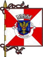
Description: In blue a black armored golden eagle with raised wings under each of which a silver erect sword accompanies him. On the chest lies a red paw cross with a common silver cross .
Over the shield a silver five-tower wall crown . In the white band at the sign foot of the place name in black capital letters "CIDADE DE PENAFIEL".
administration

The circle
Penafiel is the seat of the district of the same name ( concelho ) in the Porto district . On June 30, 2011 the district had 72,265 inhabitants on an area of 212.2 km².
The neighboring areas are (clockwise, starting in the north): Lousada , Amarante , Marco de Canaveses , Castelo de Paiva , Gondomar and Paredes .
With the regional reform in September 2013 , several municipalities were merged into new municipalities, so that the number of municipalities decreased from 38 to 28.
The following municipalities ( Freguesias ) are in Penafiel County:
| local community | Population (2011) |
Area km² |
Density of population / km² |
LAU code |
|---|---|---|---|---|
| Abragão | 2,341 | 9.53 | 246 | 131101 |
| Boelhe | 1,642 | 5.09 | 323 | 131102 |
| Bustelo | 1,697 | 6.86 | 247 | 131103 |
| Cabeça Santa | 2,528 | 6.93 | 365 | 131104 |
| Canelas | 1,649 | 11.82 | 140 | 131105 |
| Capela | 1,044 | 13.25 | 79 | 131106 |
| Castelões | 1,397 | 4.22 | 331 | 131107 |
| Croca | 1,769 | 6.64 | 267 | 131108 |
| Duas Igrejas | 2,466 | 8.10 | 304 | 131109 |
| Eja | 1,037 | 4.93 | 210 | 131110 |
| Fonte Arcada | 1,584 | 4.82 | 328 | 131112 |
| Galegos | 2,669 | 4.57 | 584 | 131113 |
| Guilhufe e Urrô | 4,001 | 7.32 | 546 | 131141 |
| Irivo | 2,182 | 3.17 | 688 | 131115 |
| Lagares e Figueira | 2,866 | 16.64 | 172 | 131142 |
| Luzim e Vila Cova | 1,640 | 10.60 | 155 | 131140 |
| Oldrões | 2,004 | 4.06 | 494 | 131121 |
| Paço de Sousa | 3,891 | 8.60 | 452 | 131122 |
| Penafiel | 15,552 | 22.52 | 690 | 131139 |
| Perozelo | 1,346 | 3.99 | 337 | 131125 |
| Rans | 1.914 | 3.05 | 627 | 131128 |
| Rio de Moinhos | 2,886 | 8.21 | 351 | 131129 |
| Rio Mau | 1,407 | 6.13 | 229 | 131138 |
| Sao Mamede de Recezinhos | 1,439 | 4.25 | 338 | 131132 |
| São Martinho de Recezinhos | 1,791 | 5.24 | 342 | 131133 |
| Sebolido | 919 | 5.15 | 178 | 131134 |
| Termas de Sao Vicente | 5,028 | 10.21 | 493 | 131143 |
| Valpedre | 1,576 | 6.33 | 249 | 131136 |
| Penafiel county | 72,265 | 212.23 | 341 | 1311 |
Population development
| Penafiel County Population (1801–2011) | |||||||||
|---|---|---|---|---|---|---|---|---|---|
| 1801 | 1849 | 1900 | 1930 | 1960 | 1981 | 1991 | 2001 | 2011 | |
| 18,576 | 26,944 | 31,799 | 37,496 | 49,924 | 64,267 | 68,444 | 71,800 | 72,258 | |
Municipal holiday
- November 11th
Town twinning
-
 Peñafiel , Spain (since 1985)
 -
 Entroncamento , Portugal (since 1991)
 -
 Sainte-Geneviève-des-Bois , France (since 1999)
 -
 Salto , Uruguay (since 2013)
Sports
The football club FC Penafiel , founded in 1951, plays in the Segunda League (2015/16). He plays his home games in the 6,500-seat municipal stadium Estádio Municipal 25 de Abril .
economy
The district is predominantly industrial, in particular the manufacturing and construction industries. Trade is also important, and agriculture and especially cattle breeding contribute to the economy in the district. The most economically developed places in the district are Penafiel, Paço de Sousa and Rio de Moinhos.
traffic
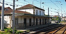
Penafiel is on the Linha do Douro railway line . Its historic train station has since been expanded to include new facilities.
The city is connected to the country's long-distance road network with its own junction on the A4 motorway (here also Europastraße 82 ). The national road N15 crosses the place and connects it with Paredes in the west and Amarante in the east.
Penafiel is integrated into the national long-distance bus network of Rede Expressos .
sons and daughters of the town
- Vitorino de Carvalho Guimarães (1876–1957), politician and Prime Minister of the First Republic
- Joaquim Oliveira (* 1947), media tycoon
- António Luís Alves Ribeiro Oliveira (* 1952), football player and coach
- Gustavo Pinto Cerqueira (* 1957), former football goalkeeper
- Vitorino José Pereira Soares (* 1960), Catholic clergyman, auxiliary bishop of Porto
- Fernanda Ribeiro (* 1969), long-distance runner and Olympic champion
- Abel Ferreira (* 1978), football player
- José Fonte (born 1983), football player
- Nuno Morais (* 1984), football player
- Nuno André Coelho (* 1986), football player
- Rui Fonte (* 1990), football player
literature
- Thomas G. Schattner (Ed.): Archaeological guide through Portugal (= cultural history of the ancient world . Vol. 74). Philipp von Zabern, Mainz 1998, ISBN 3-8053-2313-1 p. 72
Web links
- Official website of the city administration (Portuguese, English and Spanish)
Individual evidence
- ↑ a b c www.ine.pt - indicator resident population by place of residence and sex; Decennial in the database of the Instituto Nacional de Estatística
- ↑ a b Overview of code assignments from Freguesias on epp.eurostat.ec.europa.eu
- ↑ www.verportugal.net , accessed January 24, 2014
- ^ Publication of the administrative reorganization in the Diário da República gazette of January 28, 2013, accessed on March 16, 2014
- ↑ www.anmp.pt , accessed on February 1, 2014
- ↑ The Stadium Estádio Municipal 25 de Abril on www.europlan-online.de, accessed on February 1, 2014
- ↑ www.verportugal.net , accessed January 24, 2014


