Villafuerte (Valladolid)
| Villafuerte municipality | ||
|---|---|---|
 Villafuerte - Castillo
|
||
| coat of arms | Map of Spain | |
 Help on coat of arms |
|
|
| Basic data | ||
| Autonomous Community : |
|
|
| Province : | Valladolid | |
| Comarca : | Páramos del Esgueva | |
| Coordinates | 41 ° 44 ′ N , 4 ° 19 ′ W | |
| Height : | 785 msnm | |
| Area : | 26.2 km² | |
| Residents : | 80 (Jan. 1, 2019) | |
| Population density : | 3.05 inhabitants / km² | |
| Postal code : | 47180 | |
| Municipality number ( INE ): | 47206 | |
| administration | ||
| Website : | Villafuerte | |
Villafuerte (sometimes also Villafuerte de Esgueva ) is a place and a municipality with only 80 inhabitants (as of January 1, 2019) in the province of Valladolid in the region of Castile-León in Spain .
location
The place Villafuerte is located in the Iberian Meseta on the Río Esgueva a good 41 km (driving distance) northeast of Valladolid or a good 26 km northwest of the small town Peñafiel at an altitude of approx. 785 m . The climate in winter is cold, but in summer it is warm to hot; the sparse rain (approx. 440 mm / year) falls over the year.
Population development
| year | 1857 | 1900 | 1950 | 2000 | 2017 |
| Residents | 544 | 650 | 486 | 154 | 86 |
The significant population decline since the middle of the 20th century is mainly due to the mechanization of agriculture , the resulting lack of jobs and the migration of many families to the larger cities ( rural exodus ).
economy
For centuries, the inhabitants lived mainly as self-sufficient farmers from agriculture, which also included a little cattle-raising (sheep, goats, chickens) and, to a lesser extent, viticulture. Any surpluses generated could only be sold with difficulty because of the great distances to the urban markets.
history
In the 8th century, the area was used by the Moors conquered, but in the early 9th century Asturian-Leonese army of conquered areas north Duero back ( reconquista ) . At the end of the 10th century, the Moorish military leader Almansor temporarily destroyed the Christian successes. In the 11th century, the Kingdom of León extended its territory again to the Duero border; The first written mention of the place name comes from the year 1192. After previous unsuccessful attempts, León finally united with the rising Kingdom of Castile in 1230 . The town experienced its heyday in the late Middle Ages and in the early modern period under a former Jewish landlord family .
Attractions
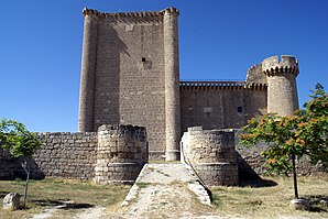
- The Castillo de Villafuerte was built between 1464 and 1480 at the instigation of Garci Franco de Toledo, a converted Jewish businessman from Valladolid, who may have sought protection from pogroms , which were frequent at the time . At the keep (torre del homenaje) is the stone heraldic shield of his wife, María de Saravia. It is noteworthy that all corners of the structure are rounded or surrounded by round towers .
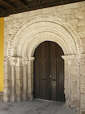
- The town's church, built in the late 12th century but later repeatedly revised (Iglesia de la Santísima Trinidad, formerly Iglesia de San Miguel Arcángel) looks squat and small. The apse (later plastered) and the Romanesque portal are still preserved from the original building; the formerly the nave (nave) covering Artesonado -Ceiling is now in the Palacio Pimentel , Valladolid.
- Surroundings
- Approx. The newly built Ermita de la Virgen de Medianedo is 1 km northeast of the village ; the interior preserves a 16th century figure of Christ venerated in the region.
Web links
Individual evidence
- ↑ Cifras oficiales de población resultantes de la revisión del Padrón municipal a 1 de enero . Population statistics from the Instituto Nacional de Estadística (population update).
- ↑ Villafuerte - climate tables
- ^ Villafuerte - population development
- ^ Villafuerte - Castillo
- ↑ Villafuerte - Church
- ^ Villafuerte - church portal

