Santovenia de Pisuerga
| Municipality of Santovenia de Pisuerga | ||
|---|---|---|
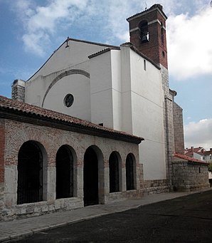
 Santovenia de Pisuerga - Iglesia de San Juan Bautista
|
||
| coat of arms | Map of Spain | |

|
|
|
| Basic data | ||
| Autonomous Community : |
|
|
| Province : | Valladolid | |
| Comarca : | Campiña del Pisuerga | |
| Coordinates | 41 ° 42 ′ N , 4 ° 41 ′ W | |
| Height : | 692 msnm | |
| Area : | 13.82 km² | |
| Residents : | 4,480 (Jan 1, 2019) | |
| Population density : | 324.17 inh / km² | |
| Postal code : | 47155 | |
| Municipality number ( INE ): | 47155 | |
| administration | ||
| Website : | Santovenia de Pisuerga | |
Santovenia de Pisuerga is a place in northern Spain and a municipality ( municipio ) with 4,480 inhabitants (as of January 1, 2019) in the province of Valladolid in the autonomous region of Castile-León ; the community belongs to the " Cigales DO " wine-growing region .
location
The place Santovenia de Pisuerga is located on the east bank of the Río Pisuerga near the Autovía A-62 at an altitude of about 692 m . The distance to the southwestern provincial capital Valladolid is only 7 km (driving distance). The climate in winter is harsh, but in summer it is dry and warm; the rather sparse rain (approx. 420 mm / year) falls mainly in the winter half-year.
Population development
| year | 1857 | 1900 | 1950 | 2000 | 2017 |
| Residents | 309 | 315 | 550 | 2,278 | 4,298 |
The population growth since the 1940s is mainly due to the proximity to the city of Valladolid and the establishment of new building districts.
economy
The area around Santovenia de Pisuerga was and is to a large extent agricultural, with livestock traditionally playing a less important role; the place offered the necessary regional services in the fields of handicraft and trade. Santovenia de Pisuerga is part of the small wine-growing region " Cigales "; tourism only plays a subordinate role.
history
Around 400 BC The area was inhabited by the Celtic ethnic group of the Vaccaeans . In the 2nd century BC BC the Romans brought large parts of the Iberian Peninsula under their control; they also brought the art of viticulture with them. In the 5th century AD the Vandals came , but they were pushed to North Africa by the Visigoths . In the 8th century, Arab-Moorish armies advanced far to the north, but were unable to conquer the areas north of the Cantabrian Mountains ( Basque Country , Cantabria , Asturias , Galicia ). Already in the 10th and 11th centuries they were pushed south by Christian armies ( reconquista ) , with the Duero valley, about 15 km south of Santovenia de Pisuerga, delimiting the respective spheres of influence for a long time. The first mention of the place name comes from the year 1092.
Attractions
- The originally Romanesque Iglesia de San Juan Bautista is dedicated to John the Baptist . In the 16th century the apse was renewed; The nave was also to be enlarged, but the work that had begun was never completed. The main altar dates from 1788.
- The small Ermita de Jesús Nazareno stands on the outskirts; it is a work from the 1960s on the site of a previous building that had been demolished.
- Also on the outskirts is a spring (fuente) and a washing area (lavadero) .
Web links
Individual evidence
- ↑ Cifras oficiales de población resultantes de la revisión del Padrón municipal a 1 de enero . Population statistics from the Instituto Nacional de Estadística (population update).
- ↑ Santovenia de Pisuerga - climate tables
- ↑ Santovenia de Pisuerga - Population Development
- ↑ Santovenia de Pisuerga - History
- ↑ Santovenia de Pisuerga - Church
- ↑ Santovenia de Pisuerga - Ermita
