
Monteroduni
| Monteroduni | ||
|---|---|---|

|
|
|
| Country | Italy | |
| region | Molise | |
| province | Isernia (IS) | |
| Coordinates | 41 ° 31 ' N , 14 ° 10' E | |
| height | 468 m slm | |
| surface | 37.02 km² | |
| Residents | 2,090 (Dec. 31, 2019) | |
| Population density | 56 inhabitants / km² | |
| Post Code | 86075 | |
| prefix | 0865 | |
| ISTAT number | 094030 | |
| Popular name | Monterodunesi | |
| Patron saint | Archangel Michael (September 29) | |
| Website | Monteroduni | |

Monteroduni is an Italian municipality ( comune ) with 2090 inhabitants (as of December 31, 2019) in the province of Isernia in Molise . The municipality is located about 9 kilometers southwest of Isernia and borders directly on the province of Caserta . The Volturno , whose ancient name Olotrunus also stands for the place name, forms the north-western boundary of the municipality.
history
The community was already known as a Samnite settlement in ancient times. The Vandals destroyed the village in 456 AD.
Attractions

Panorama from the southwest

Town center from the southeast
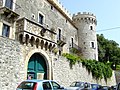
Castello Pignatelli


traffic
Strada Statale 85 Venafrana leads through the municipality from Venafro towards Isernia.
Web links
Individual evidence
- ↑ Statistiche demografiche ISTAT. Monthly population statistics of the Istituto Nazionale di Statistica , as of December 31 of 2019.

Acquaviva d'Isernia | Agnone | Bagnoli del Trigno | Belmonte del Sannio | Cantalupo nel Sannio | Capracotta | Carovilli | Carpinone | Castel San Vincenzo | Castel del Giudice | Castelpetroso | Castelpizzuto | Castelverrino | Cerro al Volturno | Chiauci | Civitanova del Sannio | Colli a Volturno | Conca Casale | Filignano | Forlì del Sannio | Fornelli | Frosolone | Isernia | Longano | Macchia d'Isernia | Macchiagodena | Miranda | Montaquila | Montenero Val Cocchiara | Monteroduni | Pesche | Pescolanciano | Pescopennataro | Pettoranello del Molise | Pietrabbondante | Pizzone | Poggio Sannita | Pozzilli | Rionero Sannitico | Roccamandolfi | Roccasicura | Rocchetta a Volturno | San Pietro Avellana | Sant'Agapito | Santa Maria del Molise | Sant'Angelo del Pesco | Sant'Elena Sannita | Scapoli | Sessano del Molise | Sesto Campano | Vastogirardi | Venafro