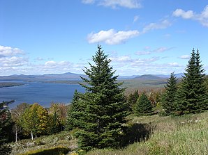
Mooselookmeguntic
| Mooselookmeguntic | ||
|---|---|---|
 View of Mooselookmeguntic |
||
| Location in Maine | ||
|
|
||
| Basic data | ||
| State : | United States | |
| State : | Maine | |
| County : | Franklin County | |
| Coordinates : | 44 ° 58 ′ N , 70 ° 48 ′ W | |
| Time zone : | Eastern ( UTC − 5 / −4 ) | |
| Height : | 451 m | |
| Postal code : | 04964 | |
| FIPS : | 47075 | |
| GNIS ID : | 571650 | |
Mooselookmeguntic is an unincorporated community in the area of Town Rangeley , in Franklin County , Maine in the United States .
Mooselookmeguntic is located between Mooselookmeguntic Lake and Rangeley Lake , it belongs to the Rangeley Lakes Region.
The name Mooselookmeguntic comes from the Abenaki and means where the hunters watch the moose at night or where the moose are feeding . It is the longest place name in the United States without a hyphen ( hyphen ).
Individual evidence
- ↑ Mooselookmeguntic in the Geographic Names Information System of the United States Geological Survey , accessed May 10, 2018
- ^ Rangeley Lakes Region History - Rangeley-Maine.com . In: Rangeley-Maine.com . ( rangeley-maine.com ).
- ^ A Moose's History of North America . Brandylane Publishers Inc, 2010, ISBN 978-1-883911-87-4 , pp. 85 ( books.google.de ).
Web links
Commons : Mooselookmeguntic, Maine - Collection of images, videos, and audio files

