Morre (Billbach)
|
Morre (lower course: Saubach ) |
||
|
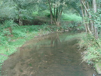
The Morre in the lower Morretal near Schneeberg |
||
| Data | ||
| Water code | DE : 24724 | |
| location |
Building land (landscape)
|
|
| River system | Rhine | |
| Drain over | Billbach → Mud → Main → Rhine → North Sea | |
| source |
Morre spring in the southeast of Hettingen 49 ° 31 '3 " N , 9 ° 22' 11" E |
|
| Source height | approx. 380 m above sea level NN | |
| confluence | between Schneeberg and Amorbach from the left with the Marsbach to Billbach Coordinates: 49 ° 38 '24 " N , 9 ° 14' 16" E 49 ° 38 '24 " N , 9 ° 14' 16" E |
|
| Mouth height | approx. 160 m above sea level NN | |
| Height difference | approx. 220 m | |
| Bottom slope | approx. 9.9 ‰ | |
| length | 22.2 km | |
| Catchment area | 100.995 km² | |
| Left tributaries | Hollerbach , Steinbächle , Winterbach | |
| Right tributaries | Hainsterbach | |
|
The Morre (front) joins the Marsbach (right) to the Billbach |
||
The Morre, or Saubach in the lower reaches, is the left source stream of the Billbach in the Odenwald in Baden-Württemberg and Bavaria .
geography
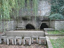
Morre spring
The Morre rises from a contained karst spring in the center of Hettingen . The spring water flows directly from a rock, which is the exit of a branched underground karst cave system in the Lower Muschelkalk . The facility around the spring was built in the 1970s. The Morre spring mostly dries up on dry days.
course
After its source, the Morre runs west through the town of Buchen , then bends north-northwest and takes on the Hollerbach . After about 3.2 km your largest tributary flows, the Steinbächle from the left. The Morre flows through Hettigenbeuern to Bavaria and reaches Zittenfelden . West of Schneeberg the Morre joins from the left with the smaller Marsbach to form the short Billbach , which then drains over the Mud into the Main .
Catchment area
The Morre has a catchment area of about 101 km², which tapers like a sector to its confluence with the somewhat smaller Marsbach, whose catchment area borders in the northeast. On the greater part of this watershed beyond its left tributary Eiderbach competes . On the southeast and southern watershed drainage area is bordered on the Jagst the Neckar current Seckach to, on the southwest just that of the Neckar tributary Elz . To the west of the entire catchment area back to the estuary in the far north, the Mud is constantly converging. This watershed, which often runs very close to the upper Mudtal, is up to 478.5 m above sea level. NHN greatest heights.
The catchment area is naturally divided into a very small portion in the Buchener Platte sub-area of the building land . The much larger in the sandstone Odenwald begins in Buchen itself , the heights are predominantly in the lower area of Winterhauch , the valley course soon in the lower area of the Upper Mudtal , to which the valleys of the large mud influxes are also included.
Tributaries
List of tributaries from the source to the mouth. Water length and catchment area according to the corresponding layers on the LUBW online map. Other sources for the information are noted.
Selection.
- Daunbächle (left, 2.1 km and 2.4 km²)
- Bödigheimer Bach (left, 2.7 km and 4.8 km²)
- Hainsterbach (right, 3.9 km and 6.2 km²)
- Hollerbach (left, 5.1 km and 11.3 km²)
- Steinbächle (left, 8.9 km and 21.0 km²)
- Taubenkladgraben (left, 1.6 km and 1.7 km²)
- Seichterbach (right, 2.3 km and 4.3 km²)
- Winterbach (left, 3.8 km and 4.7 km²)
- Mannest (left, 1.1 km and 3.5 km²)
- Mouse blade (right)
- Hesselbrunngraben (left)
- Müllersbrunngraben (left)
- Bach from the Zittenfelden source (left)
Billbach river system
Geology, landscape and protected areas
The Morre arises in the Lower Muschelkalk , which stretches out on the northwestern edge of the arable land to the Odenwald in a strip only a few kilometers wide. Immediately after Buchen it enters the eastern Odenwald, where red sandstone forms the subsoil. In this forest landscape it flows in ever deeper Kerbsohlental up to its confluence with the Marsbach.
The almost untouched upper Morretal between Buchen and Hettigenbeuren was designated as a landscape protection area with an ordinance of the then Buchen district office of April 24, 1940 with a size of 167.1 hectares . It has the protected area number 2.25.014 and is part of the FFH area "Odenwaldtäler Buchen-Walldürn" . The Morretal is also called "Mühltal" because of several mills in the upper reaches. Between 1345 and 1976, the Morre was used to water meadows . Today the remains of the weirs , retaining walls and trenches built for this purpose can still be seen.
Individual evidence
LUBW
Official online waterway map with a suitable section and the layers used here: Course and catchment area of the Morre
General introduction without default settings and layers: State Institute for the Environment Baden-Württemberg (LUBW) ( notes )
- ↑ a b Height according to the contour line image on the topographic map background layer .
- ↑ a b Length according to the waterway network layer ( AWGN ) .
- ↑ Catchment area summed up from the sub-catchment areas according to the basic catchment area layer (AWGN) .
- ↑ Height according to black lettering on the background layer topographic map .
- ↑ Catchment area according to the basic catchment area layer (AWGN) .
Other evidence
- ↑ Otto Klausing: Geographical land survey: The natural space units on sheet 151 Darmstadt. Federal Institute for Regional Studies, Bad Godesberg 1967. → Online map (PDF; 4.3 MB)
- ^ Horst Mensching , Günter Wagner : Geographical land survey: The natural space units on sheet 152 Würzburg. Federal Institute for Regional Studies, Bad Godesberg 1963. → Online map (PDF; 5.3 MB)
Remarks
- ↑ a b There are significant differences in the allocation of the sub-areas between the two natural area maps that meet in Buchen. Representation here preferably based on the map with the larger area share.
literature
- Topographic map 1: 25,000 Baden-Württemberg, as single sheet No. 6321 Amorbach, No. 6322 Hardheim, No. 6421 Buchen (Odenwald), No. 6422 Walldürn, No. 6521 Limbach


