Municipio Bolpebra
| Municipio Bolpebra | ||
|---|---|---|
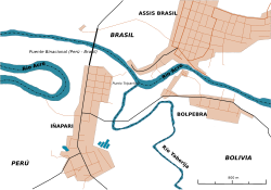
 Border triangle near San Pedro de Bolpebra |
||
| Basic data
|
||
| Population (state) - population density |
2173 population (2012 census) 1 population / km² |
|
| Post Code | 09-0103 | |
| Telephone code | (+591) | |
| surface | 2,459 km² | |
| height | 280 m | |
| Coordinates | 11 ° 15 ′ S , 69 ° 15 ′ W | |
|
|
||
| politics
|
||
| Department | Pando | |
| province | Nicolás Suarez Province | |
| Central place | San Pedro de Bolpebra | |
| mayor | Maximo Ayllon Martinez (ADN) | |
 Location of the municipality in the department of Pando |
||
| climate | ||
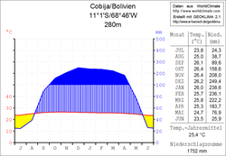
 Climate diagram Cobija |
||
The municipality of Bolpebra is a district in the Pando department in the lowlands of the South American Andean state of Bolivia .
Location in the vicinity
The municipality of Bolpebra is one of four municipalities in the province of Nicolás Suárez and includes its western area. It is bordered to the west by the region of Madre de Dios of the Republic of Peru , on the south by the municipality of Filadelfia of manuripi province , in the southeast on the municipality of Porvenir , in the northeast of the municipality of Cobija , and on the north by the state of Acre of the Republic of Brazil .
The municipality extends between about 10 ° 57 'and 11 ° 28' south latitude and 69 ° 00 'and 69 ° 34' west longitude, its extent from west to east and from north to south is up to 55 kilometers.
The municipality comprises twenty municipalities ( localidades ), the central place of the municipality is the town of San Pedro de Bolpebra with 132 inhabitants ( 2012 census ) in the north-western triangle of the district. The most populous place in the municipality is Mukden with 432 inhabitants in the central part of the district.
geography
The municipality of Bolpebra is located in the Bolivian part of the Amazon basin , northeast of the foothills of the Peruvian Cordillera Oriental in the tropical rainy climate of the equatorial zone.
The temperature fluctuations are low, both during the day and during the year. The annual average temperature is 25 ° C. The humidity is high, so that there is repeated heavy rain for much of the year . The annual precipitation of around 1750 mm is more than double the precipitation in Central Europe. Only the months of June to August are characterized by a dry season , in which the low rainfall evaporates quickly.
population
The population of the municipality of Bolpebra has almost doubled over the past two decades:
- 1992 : 1,129 inhabitants ( census )
- 2001 : 1,194 inhabitants (census)
- 2012 : 2,173 inhabitants (census)
The population density in the last census of 2012 was 0.9 inhabitants / km², the literacy rate among those over 6 years of age had improved from 43.6 percent ( 1992 ) to 74.9 percent ( 2001 ). The life expectancy of newborns in 2001 was 61.2 years, and infant mortality had deteriorated from 6.1 percent ( 1992 ) to 7.5 percent in 2001.
68.9 percent of the population speak Spanish , 4.6 percent speak Quechua , 3.2 percent speak Aymara and 30.2 percent speak foreign languages, primarily Brazilian due to the municipality's location . ( 2001 )
91.4 percent of the population have no access to electricity , 70.5 percent live without sanitary facilities . ( 2001 )
51.7 percent of the total of 292 households have a radio, 5.8 percent a television, 20.2 percent a bicycle, 14.4 percent a motorcycle, 4.8 percent a car, 2.1 percent a refrigerator, and 0 percent a telephone. ( 2001 )
politics
Results of the elections to the municipal council ( concejales ) in the regional elections on April 4, 2010:
| Eligible voters | be right | valid | CP | MAS -IPSP | MNR | MSM | ||
|---|---|---|---|---|---|---|---|---|
| 981 | 885 | 715 | 331 | 251 | 73 | 60 | ||
| 100% | 80.8% | 46.3% | 35.1% | 10.2% | 8.4% |
structure
The municipality Bolpebra was subdivided in the last census of 2012 in the following two cantons ( cantones ):
- 09-0103-1 Canton of Mukden (Bolpebra) - 11 municipalities - 1,331 inhabitants
- 09-0103-2 Cantón Chapacura - 9 municipalities - 842 inhabitants
Localities in the municipality of Bolpebra
- Canton of Mukden
- Mukden 432 pop - San Pedro de Bolpebra 132 pop
- Canton of Chapacura
- Naerufa pop. 343.
Individual evidence
- ↑ Instituto Nacional de Estadística (INE) 1992
- ^ Instituto Nacional de Estadística (INE) 2001
- ↑ Instituto Nacional de Estadística (INE) 2012 ( Memento of the original of July 22, 2011 in the Internet Archive ) Info: The archive link has been inserted automatically and has not yet been checked. Please check the original and archive link according to the instructions and then remove this notice.
- ↑ Acta de computo Nacional Electoral Departamentales, Municipales y Regional 2010
Web links
- Plan Municipal de Ordenamiento Territorial de la Mancomunidad Unión Amazónica Filadelfia-Bolpebra Land use plan Filadelfia-Bolpebra 2006 (PDF; 3.32 MB) ( Spanish )
- Bolpebra region - topographic map 1: 100: 000 (PDF; 10.90 MB)
- Municipio Bolpebra - General Maps No. 90103
- Municipio Bolpebra - detailed map and population data (PDF; 429 kB) ( Spanish )
- Departamento Pando - social data of the municipalities (PDF; 2.5 MB) ( Spanish )
