
Namaland
| Namaland | |
|---|---|

|
|
| Capital | no |
| size | 21,677 km² |
| Residents | 34,806 (1960) |
| Form of government | Homeland |
| Chairman of the Executive Council |
|
| founding | 1980 |
| resolution | May 1989 (before Namibia's independence ) |
| currency | South African rand |
| license plate | SWA |
 Location of the former homeland of Namaland |
|
Namaland is the name of a former main settlement area of the Nama and later Homeland in what is now Namibia . After Namibia's independence in 1990, the name was officially abolished; Today, Namaland lies in the administrative regions of ǁKaras , Hardap , Khomas , Erongo and Omaheke .
Settlement area
Namaland was the name introduced by the German colonial administration for the area of the Nama in the extreme south of the colony German South West Africa . However, the settlement area reached south across the Orange River into the northern Cape Province and is still called Namaqualand there today .
During the colonial period, a distinction was made between Greater Namaland , north of the Orange River, and Little Namaland , south of the Orange River . The former was part of the German colonial area from 1884-1919, the latter part of the British colonial area. Greater Namaland extended from latitude 23 degrees south to the aforementioned border river and from the Atlantic coast to the adjacent British Bechuanaland . Little Namaland , on the other hand, formed the north-west of the British Cape Colony .
Homeland
The name was adopted in 1980 by the South African administration and used in connection with the Odendaal Plan as the name of the homeland assigned to the Nama . For this purpose, the existing reserves Berseba , Tses , Krantzplatz not far from Gibeon and Soromas not far from Bethanien with 164 white farms were declared homeland .
From July 1, 1980 to March 31, 1985, Cornelius Cloete was chairman of the Namaland Executive Council. He was followed by Daniel Luipert until May 1989 . Unlike in other homelands, there was no official capital, even if Gibeon is often mentioned as such.
The area was 21,677 square kilometers and had 34,806 inhabitants in 1960.
Historical gallery
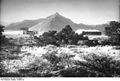
Landscape of Greater Namaland

Landscape of Greater Namaland

Landscape of Greater Namaland
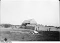
Farm in Greater Namaland


Individual evidence
- ↑ Groß-Namaland , in: Deutsches Kolonial-Lexikon , Volume I, Leipzig 1920, p. 760.
- ↑ Klein-Namaland , in: Deutsches Kolonial-Lexikon , Volume II, Leipzig 1920, p. 309.
- ↑ Hartmut Reader: Changes in population and economic-geographic conditions in South West Africa in the light of the historical and political development in southern Africa , in: Geographische Zeitschrift , Franz Steiner Verlag, October 1970, edition 58/3, pp. 198-213.
- ↑ Namaland. WorldStatesmen.org. Retrieved March 6, 2020.
- ↑ Reinhart Kössler: From Reserve to Homeland: Local Identities and South African Policy in Southern Namibia . In: Routledge (Ed.): Journal of Southern African Studies . 24, No. 3, September 2000, pp. 447-462. doi : 10.1080 / 713683582 .
- ^ South-West Africa, Proposed Homelands. in: The Bantustan Proposals for South-West Africa, p. 181. ( Memento of the original from June 26, 2016 in the Internet Archive ) Info: The archive link was inserted automatically and has not yet been checked. Please check the original and archive link according to the instructions and then remove this notice.
Odendaal plan
Damaraland | Hereroland | Kaokoland | Namaland | Okavangoland * | Ovambo (Owamboland) * | Eastern Caprivi *
* Semi-autonomous status
Other homelands
Bushmanland |
Rehoboth |
Tswanaland