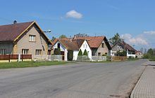
Oldřetice
| Oldřetice | ||||
|---|---|---|---|---|
|
||||
| Basic data | ||||
| State : |
|
|||
| Region : | Pardubický kraj | |||
| District : | Chrudim | |||
| Municipality : | Raná | |||
| Area : | 197 hectares | |||
| Geographic location : | 49 ° 49 ′ N , 15 ° 59 ′ E | |||
| Height: | 450 m nm | |||
| Residents : | 90 (2011) | |||
| Postal code : | 539 01 | |||
| License plate : | E. | |||
| traffic | ||||
| Street: | Skuteč - Pokřikov | |||
| Railway connection: | Havlíčkův Brod – Pardubice | |||
Oldřetice (German Oldretitz ) is a district of the municipality Raná in the Czech Republic . It lies four kilometers south of Skuteč and belongs to the Okres Chrudim .
geography
Oldřetice is located in the northern foothills of the Saar Mountains on the Raná brook ( Black brook ), to which the Dolský potok flows north of the village. In the south and west, Oldřetice is bypassed by the Havlíčkův Brod – Pardubice railway line . To the south-east lies the Drážní rybník pond.
Neighboring towns are Malinné and Žďárec u Skutče in the north, Radčice , Dolívka and Lešany in the northeast, Miřetín, Česká Rybná and Spálená Sázka in the east, Otradov and Pokřikov in the south-east, Vojtěchov in the south, Raná and Horní Holetín and Dolní Holetín in the south-west West and Mrákotín and Horní Prosetín in the north-west.
history
The first documentary mention of the village took place in the country table in 1392 , when Smil Flaška von Pardubitz handed over the Richenburg with the associated 62 villages to Otto von Bergow and Boček II from Podiebrad .
In 1835, the in consisted Chrudim district located rustic village Woldřetitz of 32 houses, where 176 people lived. There was a mill in the village. The parish office was Ranna . Until the middle of the 19th century, Woldřetitz remained subject to the Richenburg rule.
After the abolition of patrimonial Voldřetice formed from 1849 a district of the Radčice municipality in the judicial district of Skuch . From 1868 the village belonged to the political district Hohenmauth . In 1869 Voldřetice had 194 inhabitants. In the 1880s Voldřetice broke away from Radčice and formed its own municipality. In 1900 there were 159 people living in Voldřetice , in 1910 there were 177. Since 1924 the place has the official name Oldřetice . In 1930 Oldřetice had 170 inhabitants. In 1949 the community was assigned to the newly formed Okres Hlinsko, and since 1961 it has belonged to Okres Chrudim. On July 1, 1974, it was incorporated into Raná. The timber mill was moved to the Vysočina open-air museum in Veselý Kopec in 1977 . In the 2001 census, 81 people lived in the 34 houses in Oldřetice.
Community structure
The district of Oldřetice forms a cadastral district.
Attractions
- Chapel of Our Lady of La Salette, built in 1894
- Cross on the village square, erected in 1882
literature
- Historický lexikon obcí České republiky 1869–2005 , part 1, p. 514
Web links
Individual evidence
- ↑ http://www.uir.cz/katastralni-uzemi/709948/Oldretice
- ^ Johann Gottfried Sommer : The Kingdom of Bohemia; Represented statistically and topographically. Volume 5: Chrudimer Kreis. Prague 1837, p. 248


