
Place-name sign


The term place- name sign (colloquially place-name sign ) describes a sign that is located at the beginning or end of a place and gives the place name . Place-name signs are part of the signposting as they serve as an orientation aid for road users. In many countries, however, the place-name sign is also a traffic sign with a corresponding significance under road traffic law . For example, inner-city speed restrictions usually begin at the front of the signpost facing away from the interior of the city and end at the back of the sign facing the interior of the city.
designation
In the German-speaking countries, the signs that were initially set up in the town centers since the 19th century and which reproduced the place names, among other things, were referred to as "place-name signs". This name has been preserved in the road traffic regulations to this day.
historical development
.png)

Place signs can be found in almost all parts of the world today and are therefore considered commonplace. The current form largely corresponds to the requirements of motorized traffic and has been in use since the 1930s. In the period before that, the place-name sign went through various stages of development, although it is not possible to determine the exact time of its creation. It is noticeable, however, that the history of the place-name sign is closely linked to the history of signposts and distance stones . Preserved Roman milestones prove that the names of economically or militarily important cities were already written on the distance stones along the Roman roads in ancient Europe . This made it easier for the traveling combat units, administrative officials and merchants to keep their bearings and at least knew the name of the nearby provincial capital.
After the fall of the Roman Empire, there was no significant change or further development of this system in the following centuries. A lack of maintenance even led to the fact that a large number of Roman spacer stones were lost over the years and with them the place names marked. However, it can be assumed that important places continued to make their names recognizable from the outside. They either maintained the existing spacer blocks or they erected wooden panels that were not very durable. A systematic and comprehensive labeling of place names did not take place. Only the up-and-coming postal system in the 18th century provided a new upswing in the marking of place names . In the Electorate of Saxony , for example, in accordance with state requirements from 1721, in front of the city gates and later alternatively on the market square or other traffic junction of the city, post distance columns with distance information were set up, which also named the respective place names. This also applies to the subsequent Royal Saxon milestones , in the form of the station stones at the beginning and end of the postal courses in the period from 1859 to 1866. According to the ordinance of the Saxon state government, concerning the erection of signposts and place-name signs, of January 29, 1820, which was valid until 1934, signposts and place-name signs were also set up by the municipalities in Saxony , first in wood and later also in local stone. At the end of the 19th century, the corridor and district stones on the borders of the commune, manor and state forest area followed . Before that, at least in the Saxon cities of Dresden , Freiberg and Leipzig there were so-called city boundary or soft-image columns or stones from the 16th to 18th centuries. T. are still preserved today.

Soft image sign Connewitz Cross from 1536 in Leipzig (copy 1994, original in the city museum)

Soft stone from 1679 on Chemnitzer Strasse in Dresden-Plauen

City boundary or soft picture column from 1791 and place name sign in Freiberg

Royal Saxon station stone (around 1860) in Adorf

Signpost and corridor stone (around 1900) in Höckendorf

Signpost with location information (around 1900) and place name sign in Fördergersdorf


Place signs in the true sense of the word then appeared in the Kingdom of Württemberg at the beginning of the 19th century . These were attached to a stick and placed in the center of the village and were mostly made of wood. Initially, these so-called local sticks essentially served as an orientation aid for non-local residents. In the middle of the century, however, the administrative authorities recognized their value and began to use the place-name signs for administrative purposes. The panels (henceforth called troop panels ) were made of cast iron according to fixed standards and provided with information on the associated administrative and military units.
Other German-speaking states, such as the Kingdom of Bavaria , Austria or the Grand Duchy of Mecklenburg , introduced similar place-name signs (made of cast iron and wood) at the same time. As a rule, the place-name signs were attached to a prominent point (town center or town hall). Often there were also signposts with information on distances to larger towns in the area. A common designation in Austria is "Ortschaftstafel", which can be found even more often as a relic. It contained the name of the village, the municipality, the judicial district, the political district and in some countries also the name of the respective federal state.

Kingdom of Württemberg :
Draft for a town sign
(around 1863)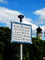
Kingdom of Bavaria :
place-name sign in Bernried
(after 1879)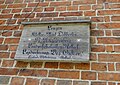
Grand Duchy of Mecklenburg :
town sign in Lenzen
(around 1888)
Kingdom of Saxony :
Signpost column as a place-name sign in Helbigsdorf near Wilsdruff
(around 1900)
Austria :
place-name sign in Kreuth, Austria
(date unknown)
Austria :
place-name sign in Neudorf bei Staatz, Austria
(date unknown)


_Schild_2011-05-24_208.JPG)


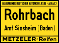
A new step in development came with the advent of the automobile and tourism at the beginning of the 20th century. Organizations (such as bicycle and automobile clubs ) were formed in many European countries to stand up for the interests of travelers. In order to make it easier for strangers to find their way around, they financed the erection or attachment of place-name signs. The place-name signs were usually made of enamelled sheet metal and, in addition to the place name, also indicated the distance to the nearest localities, the name of the organization or advertising. The authorities developed the first traffic signs a few years later, but these were only signs to warn and regulate vehicle traffic. It was not until the 1930s that many countries began to introduce place-name signs as traffic signs. For example, they were included in the German Road Traffic Act in 1934. This step was taken in Upper Austria in 1937. The newly introduced place-name signs were designed to be free of advertising and made the place names clearly legible. Since the place-name signs in many countries now also mark the beginning of an inner-city speed limit, they were no longer placed inside the village, but on its outer borders.
German Empire
(1923–1934)
United Kingdom
(early 20th century)
Italy
(early 20th century)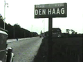
Netherlands
(around 1934)
France
(around 1934)
,_ADAC.svg)


,_plaque_Michelin_de_1934_%C3%A0_l%27entr%C3%A9e_nord_du_village.jpg)
layout
Place-name signs are not designed uniformly around the world and in some cases show very large differences in terms of color and typeface. The most important part of the place name sign is in any case the place name. He is in the official languages in either uppercase or Versalschrift displayed on the sign. For reasons of readability, the font consists of sans serif characters ( e.g. TERN ). In some countries and regions, the place names on the place-name signs are also given in several languages or, in addition to the local (e.g. Greek or Cyrillic ) alphabet , also in the Latin alphabet .
Usually the place name is shown in a dark font on a light background. The opposite case, i.e. light text on a dark background, can also be found in some countries. The place name is often framed, which makes the sign stand out from the environment. In addition to the place name, there are often pictograms, coats of arms or the name of higher-level administrative units ( regional authorities ) on the place-name sign . The end of the place is usually shown with the help of a diagonal bar.
Many countries follow the design guidelines of the Vienna Convention on Road Traffic Signs as part of their membership . The design guidelines stipulate that signs indicating the beginning and the end of a built-up area must contain the name, the city pictogram or both. Local information boards are then additionally given a red bar (or several parallel lines in red) that runs from the upper right corner to the lower left corner. The writing should be applied in dark color on a white or light colored background.
The place-name signs shown below reflect the design requirements of the Convention.

Character E, 7a

Character E, 7b

Character E, 7c

Character E, 7d

Character E, 8a

Characters E, 8b

Character E, 8c

Sign E, 8d
.svg)
.svg)
Country-specific regulations
Germany
The road traffic regulations in Germany differentiate between place-name signs and place-information signs. Both signs are directional signs.
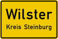
Place-name signs (signs 310 and 311 according to Appendix 3 to Section 42 Paragraph 2 StVO ) have a yellow background with black letters. Regardless of the municipal boundary and the road load limit, they are to be placed where the closed development begins or ends on one of the two sides of the road, regardless of individual undeveloped land.
Location signs (sign 385 according to Appendix 3 to Section 42 Paragraph 2 StVO) have a green background with yellow letters and a yellow border. They are used to provide information about the names of localities if there are no place-name signs. As far as settlements do not represent closed localities in the sense of the road traffic regulations, such places may not be equipped with a place name sign. In order to provide information about the place name, a place information board can be used. This mostly only occurs in places that are smaller than a village . Analogous to the designation Weiler used in southern Germany , this traffic sign is often referred to as "Weilerschild".
The colloquial separation between the place-name sign for a board at the entrance to the town and the end-of- town sign for a board at the exit is usually wrong in practice , as the place-name signs at the beginning and end of a town consist only of one board, which has been textually edited on both sides.
Sign 310-50
place name sign front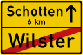
Sign 311
place sign back side
Sign 385
signpost
_mit_Kreis,_StVO_1992.svg)

Austria
The Austrian StVO only knows the designation place- name sign in § 53 / 17a and end of place in § 53 / 17b. These are information signs. Unlike in Germany, for example, speed limits set above 50 km / h are not automatically overridden and continue to apply within the local area until they are lifted.

Sign 17a
town sign
Sign 17b
end of town


Switzerland and Liechtenstein
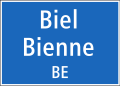
In contrast to Germany or Austria, in Switzerland and Liechtenstein there is no automatic speed limit from the place-name sign. That is why the sign “50 km / h in general” (sign 2.30.1) is usually attached above or below the place-name sign. Place-name signs are indicative of whether you are on a main street (blue place-name signs) or a side street (white place-name signs); there is also a distinction between "out of town" and "in town", for example in the VRV (prohibition of parking on main roads outside town) or in the OBV (higher buses if the maximum speed is exceeded in town). In the signaling ordinance, place-name signs are called place-name signs ; they indicate places in the colloquial, but not in the postal sense.
Sign 4.27 start of town
on main roads (Switzerland)
Sign 4.27 start of town
on main roads (Liechtenstein)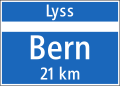
Sign 4.28
end of town on main roads (Switzerland)
Sign 4.28
end of town on main roads (Liechtenstein)
4.29
Start of town on side streets (Switzerland)
4.29
Start of town on side streets (Liechtenstein)
4.30
end of town on side streets (Switzerland)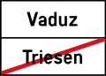
4.30
end of town on side streets (Liechtenstein)


special cases
.jpg)
.jpg)
Capital cities usually have the same place-name signs as all other localities in a country. However, if the capital is part of a metropolitan region , there are often exceptions to the signage. For example, place-name signs are either completely dispensed with (as in London, for example ) or signs are chosen that are only for information purposes and have no significance under road traffic law (as in Brussels, for example ).
Another exception is the French capital Paris . The Île de France metropolitan region consists of several political communities and departments. The innermost core of Paris, the commune “Ville de Paris”, has place-name signs that have the same appearance as all other place-name signs in France and are set up exactly on the municipality's borders (i.e. in the middle of the built-up urban area).
However, there are also capitals that are not part of a metropolitan region and yet have place-name signs that differ from the usual national signs. For example, the importance of the city is emphasized by a larger sign (such as in Tallinn ) or by adding welcome greetings and / or the city's coat of arms (such as in Oslo ).
See also
- Illustration of the place-name signs
- Place sign dispute
- Sign tower
- Place name sign (Württemberg)
- List of soft stones in Dresden
- Gallery of the Saxon post mile pillars
- Gallery of the royal Saxon milestones
- Gallery of signposts in Saxony
Web links
Individual evidence
- ↑ Guidelines for signposting outside of motorways (RWB)
- ↑ Johann Michael Voit: Theoretical-practical guide to road, bridge, water and building construction , Jenisch and Stage Verlag, 1837, page 149
- ↑ Preservation of monuments in the Rems-Murr-Kreis ( Memento of the original from September 23, 2015 in the Internet Archive ) Info: The archive link was inserted automatically and has not yet been checked. Please check the original and archive link according to the instructions and then remove this notice.
- ↑ Christoph Maria Merki: The bumpy triumphal march of the automobile 1895-1930 , Böhlau Verlag Vienna, 2002, page 337
- ↑ Example of a place-name sign for the German Touring Club
- ↑ The place-name sign is 75 years old - article at nachrichten.at from July 7, 2012
- ↑ Summary of the Vienna Conference with illustrations (PDF file; 1.4 MB)
- ↑ a b § 53 Abs. 1 Z. 17a and 17 b Road Traffic Regulations 1960
- ↑ details cf. here.