Paquetá
| Paquetá | ||
|---|---|---|
| Coordinates | 22 ° 45 '35 " S , 43 ° 6' 32" W | |

|
||
| Symbols | ||
|
||
| Basic data | ||
| Country | Brazil | |
| Rio de Janeiro | ||
| city | Rio de Janeiro | |
| ISO 3166-2 | BR-RJ | |
| Sub-prefecture | Centro e Centro Histórico | |
| surface | 1.7 km² | |
| Residents | 3361 (2010) | |
| density | 1,970.5 Ew. / km² | |
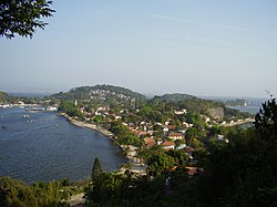
Paquetá is a district of Rio de Janeiro that is located on the island of the same name within the Guanabara Bay .
history
The island of Paquetá was discovered by the cosmographer André Thevet in 1555 during the French expedition of Nicolas Durand de Villegagnon . It wasn't until December 18, 1556, that Thevet's discovery was recognized by the French king, making that date the island's anniversary. With the victory of the Portuguese over the French in 1565, the year in which Rio de Janeiro was founded, the island passed into Portuguese possession.
The island is car-free, only bicycles and horse-drawn carts are allowed.
Surname
The name of the island comes from the Indian Tupi language and has the meaning of "many shells", which indicates the numerous shells on the beaches of the island.
nature
There are twenty on Paquetá baobabs (baobab), the only copies in Brazil. One of them is called "Maria Gorda" (fat Maria) and is kissed by the locals as a good luck charm.
Web links
- Ilha de Paquetá (Portuguese)


