
Piazza Armerina
| Piazza Armerina | ||
|---|---|---|

|
|
|
| Country | Italy | |
| region | Sicily | |
| Free community consortium | Enna (EN) | |
| Local name | Ciazza / Chiazza | |
| Coordinates | 37 ° 23 ' N , 14 ° 22' E | |
| height | 697 m slm | |
| surface | 302 km² | |
| Residents | 21,439 (Dec. 31, 2019) | |
| Population density | 71 inhabitants / km² | |
| Post Code | 94015 | |
| prefix | 0935 | |
| ISTAT number | 086014 | |
| Popular name | Piazzesi | |
| Patron saint | Santa Maria delle Vittorie | |
| Website | Piazza Armerina | |
 View of Piazza Armerina with the Colle Mira |
||

Piazza Armerina is an Italian commune in the Enna consortium in the autonomous region of Sicily with 21,439 inhabitants (as of December 31, 2019).
Location and dates
Piazza Armerina is 32 km south of Enna . The residents mainly work in agriculture or industry. Clothing, building materials and tools in particular are produced in industry.
The districts of Piazza Armerina are Monte with the Colle mira, Floristella, Grottacalda, Polleri, Santa Croce, Ileano, Azzolina, Farrugio and Serrafina. The neighboring communities are Aidone , Assoro , Barrafranca , Caltagirone ( CT ), Enna , Mazzarino ( CL ), Mineo (CT), Mirabella Imbaccari (CT), Pietraperzia , Raddusa (CT), San Cono (CT), San Michele di Ganzaria ( CT) and Valguarnera Caropepe .
history
The area has been inhabited by humans since prehistoric times. The remains of settlements and a necropolis from the 8th century BC were found in the municipality . Found. The Romans also settled here later, as the Villa Romana del Casale shows. From the 14th century, it was mainly Lombards who immigrated and settled on the mountain. The growing city was surrounded by a wall, which soon could not contain all of the new residential areas. The city continued to expand on the surrounding hills and slopes.
Today's Piazza Armerina was founded in 1080. In 1161 the city was destroyed by the Normans . It was rebuilt from 1163 onwards. The actual city developed in the Middle Ages. The Sicilian Parliament met here in 1296. The city has been the seat of a bishopric since 1817.
Infrastructure
After the railway lines to Piazza Armerina were closed between 1969 and 1971, the city can only be reached by road today.
Attractions


In the city
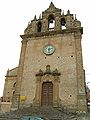
- The cathedral Maria Santissima delle Vittorie , episcopal church of the diocese of Piazza Armerina , was built from 1604; the bell tower comes from the previous church. The church on the hill dominates the cityscape, visible from afar. A small museum (Museo Diocesano) is attached to the church, in which vestments, monstrances and shrines of the archbishops are shown.
- Palazzo Trigona at the cathedral square with the picture gallery
- Palazzo Senatoro in Piazza Garibaldi
- Church of Sant'Ignazio, a baroque style church
- Spinelli Castle from the 14th century, an Aragonese castle in the heart of the city
- Garibaldi Theater

The Cathedral

In the cathedral
S. Stefano Church

S. Rocco Church

Palazzo Trigona

Palazzo di Città

Garibaldi Theater
.jpg)


In the neighborhood
-
Villa Romana del Casale , 4 km southwest of Piazza Armerina.
The well-preserved mosaics present here led to the fact that the Villa Romana del Casale was declared a World Heritage Site by UNESCO . - Church of Sant 'Andrea, consecrated in 1096, with frescoes from the 12th to 15th centuries, one of which shows Pope Pius II at mass.
Web links
- Homepage of the Commune Piazza Armerina (Italian)
- Guide to Piazza Armerina and the mosaics of the Roman Casale
Individual evidence
- ↑ Statistiche demografiche ISTAT. Monthly population statistics of the Istituto Nazionale di Statistica , as of December 31 of 2019.
- ↑ a b c d Fabrizio Ardito, Christina Gambaro et al .: Sicily. Ancient sites, temples, history, architecture, beaches, volcanoes . Vis-à-Vis series. Verlag Dorling Kindersley 2007/2008; ISBN 978-3-928044-16-5 ; Page 125

Agira | Aidone | Assoro | Barrafranca | Calascibetta | Catenanuova | Centuripe | Cerami | Enna | Gagliano Castelferrato | Leonforte | Nicosia | Nissoria | Piazza Armerina | Pietraperzia | Regalbuto | Sperlinga | Troina | Valguarnera Caropepe | Villarosa