Plaggenburg (Aurich)
|
Plaggenburg
City of Aurich
Coordinates: 53 ° 30 ′ 34 ″ N , 7 ° 32 ′ 42 ″ E
|
|
|---|---|
| Height : | 11 m |
| Area : | 13.47 km² |
| Residents : | 1475 (Jun 30, 2008) |
| Population density : | 110 inhabitants / km² |
| Incorporation : | July 1, 1972 |
| Postal code : | 26607 |
| Area code : | 04941 |
|
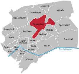
Location of Plaggenburg in the Aurich city area
|
|
Plaggenburg is a district of the district town of Aurich in the Aurich district in East Friesland , Lower Saxony . Plaggenburg has belonged to Aurich since the municipality reform in Lower Saxony that came into force on July 1, 1972. Plaggenburg is located in the northeast of the district town and is the fifth largest district by area.
history
As early as the Bronze Age, paths led through the local area to those natural elevations where the Geest protruded from the surrounding moors . They were part of a network of paths that connected the Aurich area with the Wittmund area. This network of paths was reconstructed in the 1950s by archaeologists on the basis of found artifacts.
The place itself was founded in 1777 as a bog colony , which is also indicated by the place name: The first, consistently poor houses were more like huts and were built from plagues . The first settlers were six families who originally came from the Palatinate . They came to East Frisia via an intermediate station on the Lower Rhine. The place grew very quickly in the first decades, with 215 inhabitants already attested to by 1812. In the 19th and early 20th centuries, Plaggenburg continued to gain residents, and by 1939 the number of residents had risen to 979. When refugees from the East were admitted after the war, the 1,000 inhabitants mark was broken, which has not fallen below again since then. As of 2008 Plaggenburg has 1475 inhabitants. After the Second World War, a noticeable structural change set in: Due to mechanization in agriculture, the number of people employed in this sector continued to decline. Even before it was incorporated into the city of Aurich, the district town had become the destination of many commuters from Plaggenburg.
politics
Plaggenburg has a five-member local council together with the districts of Pfalzdorf and Dietrichsfeld . Artur Mannott (CDU) has been the local mayor since the end of January 2019. He is the successor to Nikolaus Friedrichs (CDU), who gave up his office for reasons of age.
Culture and sights
- One of the noteworthy public buildings is the Lutheran St. Andrew's Church , which was built in 1904 and renovated and renewed in 1952 and 1970 to 1973. It is one of only two churches in the spacious and sparsely populated northeast of the district town. The church is named after the apostle Andrew .
- In the "Palatinate House" the history of the settlers from the Palatinate is presented, who settled in Plaggenburg in the late 18th century and later in the neighboring towns of Dietrichsfeld and Pfalzdorf. The building is the oldest Gulfhof in the village, dating from 1785. It was inhabited by the Wendeling family for more than 200 years and has been maintained by a support association since 2000.
Economy and Infrastructure
The B 210 ( Emden - Wilhelmshaven ) runs through Plaggenburg . The thoroughfare was dismantled in the 1990s, and traffic islands were created to calm traffic.
The school district of the Pfälzerschule elementary school not only covers the town, but also the neighboring towns of Pfalzdorf and Dietrichsfeld. The universal sports club Eintracht Plaggenburg and the Boßelverein Plaggenburg are located in the district.
Individual evidence
- ^ Federal Statistical Office (ed.): Historical municipality directory for the Federal Republic of Germany. Name, border and key number changes in municipalities, counties and administrative districts from May 27, 1970 to December 31, 1982 . W. Kohlhammer GmbH, Stuttgart and Mainz 1983, ISBN 3-17-003263-1 , p. 261 .
- ↑ a b Folkert Frieden, Ortschronisten der Ostfriesischen Landschaft: Plaggenburg (PDF file; 125 kB), accessed on April 3, 2012.
