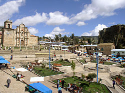
Cotabambas Province
| Cotabambas Province | ||
|---|---|---|
 Location of the province in the Apurímac region |
||
| Symbols | ||
|
||
| Basic data | ||
| Country | Peru | |
| region | Apurímac | |
| Seat | Tambobamba | |
| surface | 2613 km² | |
| Residents | 50,656 (2017) | |
| density | 19 inhabitants per km² | |
| founding | August 30, 1960 | |
| ISO 3166-2 | PE-APU | |
| Website | muniprovincialcotabambas.gob.pe (Spanish) | |
| politics | ||
| Alcalde Provincial | Rildo Guillén Collado (2019-2022) |
|
| Haquira | ||
Coordinates: 13 ° 56 ′ S , 72 ° 12 ′ W
The province of Cotabambas is one of seven provinces in the Apurímac administrative region in southern Peru . The province extends over an area of 2613 km². The 2017 census counted 50,656 inhabitants in the province of Cotabambas. Ten years earlier the population was 45,771. The provincial capital is Tambobamba .
Geographical location
The province of Cotabambas extends over the Andean highlands south of the glaciated mountain range of the Cordillera Vilcabamba . The eastern provincial border is formed by the Río Santo Tomás and Río Apurímac . The Río Vilcabamba flows along the northwestern provincial border .
The province of Cotabambas borders the Cusco region to the north, east and south and the provinces of Abancay , Grau and Antabamba to the west .
structure
The province of Cotabambas consists of 6 districts. The district of Tambobamba is the seat of the provincial administration.
| District | Administrative headquarters |
|---|---|
| Challhuahuacho | Challhuahuacho |
| Cotabambas | Cotabambas |
| Coyllurqui | Coyllurqui |
| Haquira | Haquira |
| Mara | Mara |
| Tambobamba | Tambobamba |
Web links
- Municipalidad Provincial de Cotabambas - Tambobamba
- Peru: Region Apurímac (provinces and districts) at www.citypopulation.de

