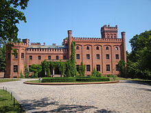
Puck (rural community)
| Gmina Puck | ||
|---|---|---|

|
|
|
| Basic data | ||
| State : | Poland | |
| Voivodeship : | Pomerania | |
| Powiat : | puck | |
| Geographic location : | 54 ° 42 ′ N , 18 ° 24 ′ E | |
| Residents : | see Gmina | |
| Telephone code : | (+48) 58 | |
| License plate : | GPU | |
| Economy and Transport | ||
| Next international airport : | Danzig | |
| Gmina | ||
| Gminatype: | Rural community | |
| Gmina structure: | 27 school authorities | |
| Surface: | 243.29 km² | |
| Residents: | 26,522 (Jun. 30, 2019) |
|
| Population density : | 109 inhabitants / km² | |
| Community number ( GUS ): | 2211072 | |
| administration | ||
| Wójt : | Tadeusz Puszkarczuk | |
| Address: | ul. 10 Lutego 29 84-100 puck |
|
| Website : | gmina.puck.pl | |
The Gmina wiejska Puck is a rural community in the Polish Pomeranian Voivodeship and Powiat Pucki (district). The seat of the rural community is the city of Puck ( German Putzig ), which belongs to the powiat, but not the community. The Gmina has an area of 243.3 km² and 26,522 inhabitants (as of June 30, 2019).
It is one of the bilingual communities in Poland , as Kashubian was introduced as the official language here . In the 2002 census , 30.9% of the population said they spoke this language.
geography


The rural parish includes the town of Puck on three sides to the south. The north-east boundaries of the city and municipality are formed by the Zatoka Pucka (Putziger Wiek) of the Baltic Sea . Neighboring communities and places are also Kosakowo , Krokowa , Reda , Rumia , Wejherowo and Władysławowo .
Community structure
The municipality includes the following localities, which form 27 school district offices ( sołectwo ), other localities without a school district office are Beka, Celbówko, Czarny Młyn, Dana, Golica, Kaczyniec, Łyśniewo, Mieroszyno-Parcele, Muza, Piaśnica, Piaśnica, Mała, Piaśnica, Piaustnica, Wielka Wielka. Sławutówko, Wiedlino and Zele:
| Polish name | Kashubian name | German name |
|---|---|---|
| Beka | Békô | Beka |
| Błądzikowo | Błãdzëkòwò | Blondszikau (1874–1939 Blansekow , 1939–1945 Blansekau ) |
| Brudzewo | Brudzéwò | Brusdau |
| Celbówko | Célbòwkò | Tannenburg |
| Celbowo | Célbòwò | Celbau (1942–1945 Zelbau ) |
| Czarny Młyn | Czôrnë Młën | Czarnauermühle |
| Darżlubie | Darżlëbié | Darslub (1942–1943 Buchheide , 1943–1945 Darpstedt ) |
| Domatówko | Domôtówkò | Klein Dommatau (1942–1945 Kleindommatau ) |
| Domatowo | Domôtowò | Groß Dommatau (1942–1945 Großdommatau ) |
| Gnieżdżewo | Gniéżdżewò | Gnesdau (1942–1945 Nesten ) |
| Kaczyniec | Kaczińc | |
| Łebcz | Łebcz | Löbsch |
| Leśniewo | Lésniéwò | Leßnau |
| Łyśniewo | Łësniéwò | Lißnau (1942–1945 Lissen ) |
| Mechowo | Mechòwa | Mechau |
| Mieroszyno | Miérëszëno | Miruschin (1942–1945 Brünhausen ) |
| Mrzezino | Mrzezëno | Bresin (1942–1945 Brambusch ) |
| Muza | Mùza | Musa (1942–1945 Mittenwalde ) |
| Osłonino | Òsłonino | Oslanin (1942–1945 Truchsassen ) |
| Mała Piaśnica | Mołô Piôsznica | Klein Piasnitz (1942–1945 Kleinpesnitz ) |
| Wielka Piaśnica | Wiôlgô Piôsznica | Groß Piasnitz (1942–1945 Großpesnitz ) |
| Połchowo | Pôłchòwò | Polchau |
| Połczyno | Pôłczëno | Polzin (1942–1945 Konradswiese ) |
| Radoszewo | Redëszéwò | Reddischau |
| Rekowo Górne | Rekòwò | Rekau |
| Rzucewo | Rzucéwò | Rutzau |
| Sławutówko | Sławùtowkò | Klein Schlatau (1942–1945 Kleinschlatau ) |
| Sławutowo | Sławùtowò | Groß Schlatau (1942–1945 Großschlatau ) |
| Smolno | Smòlëno | Pout |
| Starzyno | Starzno | Big Starsin (1942–1945 Big Stars ) |
| Starzyński Dwór | Môłé Starzno | Klein Starsin (1942–1945 Kleinstarsen ) |
| Strzelno | Strzélno | Strellin |
| Swarzewo | Swôrzéwò | Schwarzau |
| Werblinia | Warblëniô | Werblin |
| Wiedlino | Wiedlëno | Wedlin |
| Zdrada | Zdrôdô | Zdrada (1942–1945 Mechenhof ) |
| Żelistrzewo | Żelëstrzewò | Sellistrau (1942–1945 Sellen ) |
Partner communities
-
 Joint community of Oldendorf-Himmelpforten in Lower Saxony (since 2005 with the joint community of Oldendorf)
 -
 Rytro commune in Lesser Poland, south of Nowy Sącz.
Personalities
- Władysław Szymanski (* 1901 in Klein Dommatau, today Domatówko ; shot in 1940 in the Stutthof concentration camp ), Polish priest
- Hilmar Kopper (* 1935 in Osłonino , until 1919 Oslanin ), German bank manager and 1989–1997 Management Board spokesman of Deutsche Bank AG.
literature
- Hans Prutz : History of the Neustadt district in West Prussia . Danzig 1872 ( e-copy ).
- Franz Schultz : History of the districts Neustadt and Putzig. 1907.
- August Eduard Preuss : Prussian country and folklore. Königsberg 1835, p. 412f
Web links
- Rural Municipality Website (Polish)
Individual evidence
- ↑ population. Size and Structure by Territorial Division. As of June 30, 2019. Główny Urząd Statystyczny (GUS) (PDF files; 0.99 MiB), accessed December 24, 2019 .


