
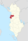
Qark Durrës
  |
|
| Qark : | Durrës |
| Seat: | Durrës |
| Former circles : | Durrës and Kruja |
| Surface: | 766 km² |
| Residents: | 262,785 as of 2011 |
|
Population density: |
343 inhabitants / km² |
| Chairman: | |
| Qark Council: | 46 members |
| Members of Parliament : | 13 |
| ISO-3166-2 code: |
AL-02
|


The Qark Durrës ( Albanian Qarku i Durrësit ) is one of the twelve Qarks in Albania . It is located in central Albania and has an area of 766 km². According to the 2011 census, it has 262,785 inhabitants; INSTAT gave 310,442 inhabitants for 2009, while the district administration even listed 414,892 inhabitants for the same year. The capital is Durrës .
geography
The Qark Durrës covers an area in central Albania around the cities of Durrës and Kruja . In the west, the Adriatic Sea forms the natural border for 61.8 kilometers. To the east of the coastal plain near Kruja rise the mountains of the Skanderbeggebirge . A small range of hills extends between the two centers of the qark, rising up to 300 meters and separating the catchment areas from the rivers Ishëm (east) and Erzen (west). The hills end in the north at Cape Rodon . All traffic between the two regions leads via Vora in Qark Tirana , where there is an almost flat passage in the chain of hills.
Today the Qark is divided into the three communities Durrës , Kruja and Shijak . The area used to be divided into the two districts of Durrës and Kruja .
To the north of the qark is Lezha qark , to the east of Dibra qark and south of Tirana qark .
population
The Qark's population is 262,785 (2011 census). In ten years the population has increased by almost 16% from 226,808 people.
The religious majority are Sunni Muslims (67.46%). The Bektashi (1.6%), Albanian Orthodox (3.3%), Roman Catholic (7.35%) and atheists (1.1%) have more or less the same number of followers.
Economy and Transport
The Qark is part of the Tirana – Durrës economic region, the economic center of the country, in which the country's most important port ( Durrës port ) and the only international airport (in the Tirana – Kruja border area) are to be found. More than a third of the population of Albania live in the entire metropolitan area .
Politics and administration
The Qark Council (alb. Këshilli i Qarkut ) based in the port city of Durrës has 46 members.
For the legislative periods of the Albanian parliament beginning in 2009 and 2013, the Qark has 13 members out of a total of 140.
| local community | Population (2011) | Old churches | circle |
|---|---|---|---|
| Durrës | 175.110 | Durrës, Ishëm, Katundi i ri, Manza , Rrashbull, Sukth | Durrës |
| Kruja | 59,814 | Bubq, Cudh, Fushë-Kruja , Kodër Thumana , Kruja, Nikël | Kruja |
| Shijak | 27,861 | Gjepalaj, Maminas, Shijak, Xhafzotaj | Durrës |
| circle | Capital | surface | Residents (Instat, 2001) |
Residents (district administration, 2009) |
Population (2011 census) |
Number of municipalities |
|---|---|---|---|---|---|---|
| Durrës | Durrës | 433 km² | 182,988 | 334.871 | 202.971 | 10 |
| Kruja | Kruja | 333 km² | 64,357 | 80.021 | 59,814 | 6th |
Web links
- Qark Durrës
- Durrës Guide (Albanian)
Individual evidence
- ↑ a b c d Ines Nurja: Censusi i popullsisë dhe banesave / Population and Housing Census - Durrës 2011 . Results Kryesore / Main Results. Ed .: INSTAT . Pjesa / Part 1. Adel Print, Tirana 2013 ( instat.gov.al [PDF; accessed April 14, 2019]).
- ↑ Shqipëria në Shifra 2010. (PDF) (No longer available online.) INSTAT, archived from the original on March 4, 2016 ; Retrieved December 20, 2015 . Info: The archive link was inserted automatically and has not yet been checked. Please check the original and archive link according to the instructions and then remove this notice.
- ↑ a b c Qarku Durrës - Statistika. (No longer available online.) Archived from the original on October 12, 2011 ; Retrieved January 2, 2012 .
- ↑ INSTAT (Ed.): Population and Housing Census in Albania 2011: Preliminary Results . Tirana December 2011 ( online version [PDF; 5.8 MB ; accessed on January 3, 2020]).
- ^ Albania Districts. In: Statoids. Retrieved October 30, 2011 .
Coordinates: 41 ° 23 ' N , 19 ° 30' E