
Répáshuta
| Répáshuta | |||||
|
|||||
| Basic data | |||||
|---|---|---|---|---|---|
| State : | Hungary | ||||
| Region : | Northern Hungary | ||||
| County : | Borsod-Abaúj-Zemplén | ||||
| Small area until December 31, 2012 : | Miskolc | ||||
| District since 1.1.2013 : | Miskolc | ||||
| Coordinates : | 48 ° 3 ' N , 20 ° 32' E | ||||
| Height : | 516 m | ||||
| Area : | 16.79 km² | ||||
| Residents : | 469 (Jan 1, 2011) | ||||
| Population density : | 28 inhabitants per km² | ||||
| Telephone code : | (+36) 46 | ||||
| Postal code : | 3559 | ||||
| KSH kódja: | 31884 | ||||
| Structure and administration (as of 2020) | |||||
| Community type : | local community | ||||
| Mayor : | Tamás Erdős (independent) | ||||
| Postal address : | Kossuth Lajos u. 2. 3559 Répáshuta |
||||
| Website : | |||||
| (Source: A Magyar Köztársaság helységnévkönyve 2011. január 1st at Központi statisztikai hivatal ) | |||||


Répáshuta ( Slovak Repašská Huta ) is a Hungarian community in the county Miskolc in Borsod-Abaúj-Zemplén .
Geographical location
Répáshuta is located in northern Hungary in the Bükk National Park, 20 kilometers west of the Miskolc county seat and 20 kilometers northeast of the city of Eger . The neighboring municipality of Bükkszentkereszt is eight kilometers east of the village.
Parish partnership
Attractions
- Balla Cave ( Balla-barlang )
- Local history museum ( Tájház )
- Nature trails ( Kőbalta Tanösvény , Rejteki Tanösvény and Tárnics Tanösvény )
- Kisboldogasszony Roman Catholic Church
- World War Memorial ( I-II. Világháborús emlék )
traffic
Répáshuta can only be reached by road No. 2505. There are bus connections to Miskolc and Eger. The nearest train station is in Miskolc-Tiszai.
photos

View of Répáshuta

Kossuth Lajos utca
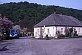
school

Local government

Culture house

Entrance to the Balla Cave

,_Hungary.JPG)


Individual evidence
- ↑ Helyi önkormányzati választások 2019 - Répáshuta (Borsod-Abaúj-Zemplén megye). Nemzeti Választási Iroda, accessed February 15, 2020 (Hungarian).
- ↑ Magyarország helységnévtára: Répáshuta. Központi Statisztikai Hivatal, accessed on February 15, 2020 (Hungarian).
Web links
- Official website of Répáshuta ( Hungarian )
- Répáshuta község címere (Hungarian)