Plümkenau
| Plümkenau Radomierowice |
||
|---|---|---|

|
|
|
| Basic data | ||
| State : | Poland | |
| Voivodeship : | Opole | |
| Powiat : | Opole | |
| Gmina : | Murow | |
| Geographic location : | 50 ° 56 ' N , 18 ° 2' E | |
| Residents : | 214 (December 31, 2017) | |
| Postal code : | 46-030 | |
| Telephone code : | (+48) 77 | |
| License plate : | OPO | |
| Economy and Transport | ||
| Street : | Murow - Wołczyn | |
| Next international airport : | Wroclaw | |
Plümkenau ( Polish Radomierowice ) is a village in the powiat Opolski of the Opole Voivodeship in Poland . As a Schulzenamt it belongs to the rural community Murow .
geography
Geographical location
The street village Plümkenau is perpendicular to the Murow - Wołczyn street in the north of the Opole Voivodeship , about 11 kilometers southwest of Kluczbork (Kreuzburg OS) and about 30 kilometers northeast of Opole between the Bogacica (Bodländer Flössbach) and the Opuste Graben in the historical region Upper Silesia .
history
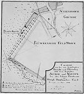
The settlement of Plümkenau was created from 1772 to 1773 as part of the Frederician colonization in the sparsely populated forests north of Opole. In 1784 the colonist settlement was mentioned as Plümkenau . It was named after the War and Domain Councilor Plümicke, to whom it was founded. Originally the name form Plümickenau was also in use . The royal Prussian commissioner Johann Hartmann Schuch visited the new Plümkenau settlement in May 1772 and listed 15 households in his Frederician colonists from Silesia that were not yet ready for occupancy. He criticized the carpenter because a hut threatened to collapse shortly after its completion. Most of the settlers came from Hessen ( Hessen-Hanau and Grafschaft Isenburg-Büdingen ), two families came from Bohemia and one from Poland.
As early as 1786 a reformed church could be built as a half-timbered building, for which the Prussian state provided the timber, followed in 1788 by a rectory and in 1789 by a Protestant school. Before joining the Evangelical Union in 1822, Reformed and one Lutheran services were celebrated in the church on two Sundays . The parish of Plümkenau looked after the surrounding Frederician colonies of Neuwedel and Süssenrode .
In the referendum in Upper Silesia on March 20, 1921, there was a unanimous vote in Plümkenau with 277 votes in favor of remaining with Germany, where the town remained.
Plümkenau belonged to the Opole district and was placed under Polish administration in 1945, which gave the place the name Radomierowice . Before 1945 the place was called Blimkinów in Polish . The Protestant parish church was taken over by the Catholic Church and today serves as a branch church of the Dąbrówka Dolna parish .
In 1999 Plümkenau became part of the re-founded Powiat Opolski . In March 2009, the place was also given the official German place name Plümkenau .
Population development
The population of Plümkenau:
|
|
Attractions
The Roman Catholic branch church of the Assumption of Mary was built in 1786 by the carpenter Petzer according to plans by the architect Christian Isemer. In 1790 the low bell tower with a welsch dome was added. The half-timbered building is covered by a high hipped roof. In the simple interior, a three-sided gallery extends under the beamed ceiling, on which the organ from before 1794 is placed. Like the altar (around 1790), it is kept in a transition style from Rococo to Classicism .
Web links
Individual evidence
- ^ Residents of Murow, December 31, 2017
- ↑ a b c Cf. Plümkenau, a settlement of Frederick the Great. In: Oberschlesien im Bild, 1935, No. 48
- ↑ Cf. dat.prosilesia.net ( Memento from May 28, 2006 in the Internet Archive ). on April 30, 2009
- ↑ Cf. Johann Georg Knie: Alphabetical-statistical-topographical overview of the villages, towns, cities and other places of the royal family. Preuss. Province of Silesia. Wroclaw 1845
- ↑ Cf. Felix Triest: Topographisches Handbuch von Oberschlesien. Wroclaw 1865
- ↑ See results of the referendum . on November 29, 2009
- ↑ Skorowidz gmin Śląska Dolnego i Opolskiego z niemieckimi i polskimi nazwami miejscowości według stanu z dnia 1 stycznia 1941 r.
- ↑ Sources of population figures : 1784: [1] - 1817: [2] - 1830: [3] - 1855, 1861: [4] - 1910: [5] - 1933, 1939: [6]
- ^ Dehio - Handbook of Art Monuments in Poland: Silesia. Deutscher Kunstverlag Munich, Berlin 2005.


