
Rattle (Taunus)
| rattle | ||
|---|---|---|
 View from the Goldstein valley to the rattle |
||
| height | 539.4 m above sea level NHN | |
| location | near Wiesbaden-Naurod ; circular free Wiesbaden , Hesse ( Germany ) | |
| Mountains | Taunus | |
| Dominance | 0.92 km → Hohe Kanzel | |
| Notch height | 17 m | |
| Coordinates | 50 ° 8 ′ 40 " N , 8 ° 15 ′ 18" E | |
|
||
 View from the summit region towards Wiesbaden |
||

The rattle is 539.4 m above sea level. NHN high mountain in the Taunus . It is located in the north of the Hessian state capital Wiesbaden and is its highest independent elevation.
geography
location
The rattle rises in the Rhein-Taunus Nature Park . Its summit is east of the Taunushauptkamm in the area of the Wiesbaden district of Naurod . Neighboring Wiesbaden districts near the mountains Sonnenberg in the west and Rambach in the east. Beyond the mountain ridge lies the Neuhofer settlement of Platte in the northwest and Wehen a little to the west .
The northeastern neighbor is the Hohe Kanzel ( 591.8 m ) and to the southwest the Steinhaufen ( 520.6 m ) with its southern spur Würzburg ( 399.4 m ) - both in the Taunus main ridge. The south-eastern neighbor is the Kellerskopf ( 474 m ).
North of the rattle in the nature reserve Theißtal of Niedernhausen springs from Theißbach , a western tributary of the Schwarzenbach dining Daisbachs . The source of the Rambach , the upper reaches of the Salzbach , lies to the east at the Kellerskopf , and the Rambach tributary Goldsteinbach rises to the southwest near the Würzburg ramparts .
Natural allocation
The rattle belongs to the natural spatial main unit group Taunus (No. 30) and in the main unit Hoher Taunus (301) to the subunit Wiesbadener Hochtaunus (301.2). The landscape falls to the south into the natural area Georgenborn Nauroder Slope Schuttfuß (301.20).
Nature and protected areas
The rattle is wooded. The approximately 300-year-old stag oak stands near the summit . To the north of the Rassel lies the Theißtal von Niedernhausen nature reserve ( CDDA no. 165875; designated in 1993; 52.65 hectares in size). The mountain is located in the conservation area town Wiesbaden (CDDA No. 555513808;. 2010; 133.2864 sq km ) and the Fauna Flora Habitat -region beech forests north of Wiesbaden (FFH No. 5815-306;. 41.243 square kilometers). To the north lies the FFH area Theiss valley of Niedernhausen with adjacent areas (FFH no. 5815-303; 82.51 ha). Parts of the FFH areas Trockenborn / Kellerskopf near Rambach (FFH No. 5815-305; 55.23 ha) and Goldsteintal near Wiesbaden with adjoining areas (FFH No. 5815-304; 59.61 ha) extend to the southern slope areas . .
Transport links and hiking
No roads lead directly to the rattle. The federal road 417 runs past the neighboring cairn and the Platte hunting lodge there . From there you can walk to the rattle on the following paths, some of which divide the route in sections. The Rheinhöhenweg on the right bank of the Rhine leads across the octagonal crossroads 330 m west of its summit and past this summit a few meters north . The European long-distance hiking trail E3 , the Taunushöhenweg and the Jubilee circular trail around Wiesbaden run across this intersection and the area of the southern slope near the summit . The short Vogel trail is laid out between the intersection and the nearby Platte hunting lodge .
gallery
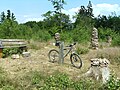
Rassel: Summit (2017)

Forest near the summit
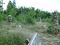
Stone towers on the summit region
.jpg)


See also
Individual evidence
- ↑ a b rattle in map services of the Federal Agency for Nature Conservation ( information )
- ↑ Heinrich Müller-Miny, Martin Bürgener: Geographical land survey: The natural spatial units on sheet 138 Koblenz. Federal Institute for Regional Studies, Bad Godesberg 1971. → Online map (PDF; 5.7 MB)
- ↑ Map services of the Federal Agency for Nature Conservation ( information )