Ribeira Grande (Azores)
| Ribeira Grande | ||||||
|---|---|---|---|---|---|---|
|
||||||
| Basic data | ||||||
| Autonomous Region : | Azores | |||||
| Concelho : | Ribeira Grande | |||||
| Coordinates : | 37 ° 49 ′ N , 25 ° 31 ′ W | |||||
| Residents: | 32,112 (as of June 30, 2011) | |||||
| Surface: | 180.14 km² (as of January 1, 2010) | |||||
| Population density : | 178 inhabitants per km² | |||||
| Ribeira Grande district | ||||||
|
||||||
| Residents: | 32,112 (as of June 30, 2011) | |||||
| Surface: | 180.14 km² (as of January 1, 2010) | |||||
| Population density : | 178 inhabitants per km² | |||||
| Number of municipalities : | 14th | |||||
| administration | ||||||
| Administration address: | Câmara Municipal de Ribeira Grande Largo Cons. Hintze Ribeiro 9600-509 Ribeira Grande |
|||||
| President of the Câmara Municipal: | José Antonio de Sousa Lima | |||||
| Website: | www.cm-ribeiragrande.pt | |||||
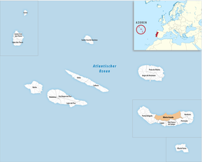
Ribeira Grande ( [ ʁiˈβɐjɾɐ ˈɣɾɐ̃d (ɨ) ] ) is the largest city in the north of the Azores - São Miguel island with 32,032 (2011) inhabitants. The river of the same name, which is also eponymous, divides the urban area into two parts. The city is made up of the municipalities of Conceição, Matriz, Ribeirinha, Ribeira Seca and Santa Bárbara.
It is the seat of the administrative district of the same name, Ribeira Grande.
history
Ribeira Grande, which is one of the oldest villages in the Azores, was granted city rights (Vila) as early as 1507 . The first settlers built watermills on the Ribeira Grande river and used water power to process wool and linen. In 1563 the city was destroyed by a volcanic eruption, in the district of Ribeira Seca a well that was buried during the eruption and later exposed is a reminder of this. 1980 Ribeira Grande was the city rights of Cidade awarded in excess of the rights of Vila go far.
economy
Agriculture was and is an important source of income for the region. The river was used to operate watermills for processing grain. In the 18th century the wool processing industry brought a temporary economic boom. A liqueur factory and a ceramics factory that produce azulejos are now considered traditional businesses . In a modern industrial park there are now more than 25 (as of 2004) companies from different industries. In addition, tourism plays an increasing role in the city's economy.
Attractions
- The main church Igreja Matriz de Nossa Senhora da Estrela was consecrated in 1517 and rebuilt after being destroyed by an earthquake in 1680.
- Jardim Publico, city park
- Igreja do Espirito Santo, also called Igreja da Misericordia, a baroque church started in 1592 and completed in the 17th century. In contrast to the representative facade, which is decorated with numerous decorative elements, its interior is kept relatively simple. A painting is kept in the church that shows Jesus carrying the cross, and on the basis of which there is a procession on the second Sunday of Lent from this church. Because of this procession, which relates to the Passion of Christ, and because of the painting, the church is also called Igreja do Senhor dos Passos .
- The town hall (Paço de Conselhos), enlarged and rebuilt several times, is one of the oldest of its kind in the Azores. A first town hall was built on this site as early as 1507, and the oldest records of a council meeting date from 1555. The multi-winged building in its current form with a representative flight of stairs and a bell tower dates primarily from the 17th and 18th centuries . The two main parts of the building are connected by an arch. In the eastern wing of the street Rua da Praça there is a richly decorated window from the 16th century in the typical Manueline style . In the 17th century the building was used as a church for the Jesuits. The basement was used as a prison at times.
- Museo Municipal da Ribeira Grande, city museum
- The theater opened in 1922.
- Arquipélago Centro des Artes contemporânea , a contemporary art museum opened in 2015 in a former factory
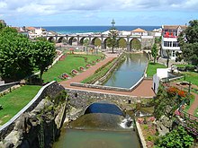
- The Ponte dos Oito Arcos bridge with its eight arches, built between 1888 and 1893, is one of the city's landmarks.
Ribeira Grande district
The following 14 municipalities ( Freguesias ) belong to the administrative district:
| local community | Population (2011) |
Area km² |
Density of population / km² |
LAU code |
|---|---|---|---|---|
| Calhetas | 988 | 4.70 | 210 | 420501 |
| Conceição | 2,425 | 12.73 | 190 | 420509 |
| Fenais da Ajuda | 1,131 | 13.36 | 85 | 420502 |
| Lomba da Maia | 1,152 | 20.47 | 56 | 420503 |
| Lomba de Sao Pedro | 284 | 8.25 | 34 | 420504 |
| Maia | 1,900 | 21.97 | 86 | 420505 |
| Matrix | 3,968 | 10.84 | 366 | 420510 |
| Pico da Pedra | 2,909 | 6.58 | 442 | 420506 |
| Porto Formoso | 1,265 | 12.79 | 99 | 420507 |
| Rabo de Peixe | 8,866 | 16.96 | 523 | 420508 |
| Ribeira Seca | 2,950 | 12.59 | 234 | 420511 |
| Ribeirinha | 2,349 | 17.98 | 131 | 420512 |
| Santa Bárbara | 1,275 | 12.84 | 99 | 420513 |
| São Brás | 650 | 8.08 | 80 | 420514 |
| Ribeira Grande district | 32,112 | 180.14 | 178 | 4205 |
Neighboring areas:
| Atlantic Ocean | ||
| Ponta Delgada |

|
Northeast |
| Lagoa | Vila Franca do Campo | Povoação |
Surroundings
There are tea plantations east of the city. The Chá Gorreana tea factory , which can be visited, is famous .
Web links
swell
- ↑ a b www.ine.pt - indicator resident population by place of residence and sex; Decennial in the database of the Instituto Nacional de Estatística
- ↑ a b Overview of code assignments from Freguesias on epp.eurostat.ec.europa.eu
- ^ Wilhelm Voss-Gerling: Madeira, Azores. Munich 1972, p. 50.
- ↑ Stéphan Szeremeta: Açores. Paris 2014, p. 99.
- ↑ Susanne Jaep: Azores. Ostfildern 1998, p. 36.
- ↑ Michael Bussmann: Azores. Ostfildern 2016, p. 204.
- ↑ Stéphan Szeremeta: Açores. Paris 2014, p. 104.
- ↑ Stéphan Szeremeta: Açores. Paris 2014, p. 103.
- ↑ Michael Bussmann: Azores. Ostfildern 2016, p. 203.
- ↑ http://www.minube.com.br/sitio-preferido/the-eight-arches-bridge-ribeira-grande-a199474#modal-84059


