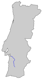
Sado (river)
|
Sado Rio Sado |
||
|
Run of the Rio Sado |
||
| Data | ||
| location | Setúbal , Beja ( Portugal ) | |
| River system | Sado | |
| source | in the Serra da Vigia 37 ° 38 ′ 28 ″ N , 8 ° 15 ′ 51 ″ W. |
|
| Source height | ~ 230 m | |
| muzzle | at Setúbal in the Atlantic Ocean Coordinates: 38 ° 29 '22 " N , 8 ° 55' 24" W 38 ° 29 '22 " N , 8 ° 55' 24" W |
|
| Mouth height | 0 m | |
| Height difference | 230 m | |
| Bottom slope | 1.3 ‰ | |
| length | 180 km | |
| Catchment area | 7640 km² | |
| Drain |
MQ |
40 m³ / s |
| Left tributaries | Ribeira de Corona , Ribeira de Grandola | |
| Right tributaries | Roxo , Ribeira da Figueira , Odivelas , Xarrama , Ribeira de Algalé , Ribeira de Santa Catarina de Sitimos , Alcáçovas | |
| Reservoirs flowed through | Monte da Rocha | |
| Medium-sized cities | Setubal | |
| Small towns | Alcácer do Sal | |
| Communities | Alvalade | |
|
The Sado at Alcácer do Sal |
||
The Sado is a river in Portugal . The source is in the Serra da Vigia mountains . From there the Sado flows about 180 kilometers in a predominantly northerly direction and flows into the Atlantic Ocean near the city of Setúbal , south of Lisbon .
The Reserve Natural do Estuário do Sado is located on the Sado river delta . In the estuary of the Sado a population lives of the dolphin species of bottlenose dolphin .
In the catchment area there are u. a. the following dams :
- Barragem de Água Industrial
- Aguas Claras ( Barranco do Morgado )
- Alvito ( Odivelas )
- Campilhas ( Campilhas )
- Daroeira ( Messejana )
- Fonte Serne ( Vale Diogo )
- Monte da Rocha (Sado)
- Odivelas ( Odivelas )
- Pego do Altar ( Alcáçovas )
- Barragem de Porches
- Rejeitados ( Barranco do Morgado )
- Roxo ( Roxo )
- Barragem da Tapada
- Vale do Gaio ( Xarrama )
Web links
Commons : Sado - collection of images, videos and audio files

