
Rod an der Weil
|
Rod an der Weil
municipality Weilrod
|
|
|---|---|
 |
|
| Height : | 271 m above sea level NHN |
| Area : | 7.72 km² [LAGIS] |
| Residents : | 925 (Jan. 2017) |
| Population density : | 120 inhabitants / km² |
| Incorporation : | August 1, 1972 |
| Postal code : | 61276 |
| Area code : | 06083 |
 Location of Rod an der Weil in Weilrod
|
|
Rod an der Weil is the main town in the community of Weilrod in the Hessian Hochtaunuskreis .
Geographical location
Rod an der Weil is located in the Weiltal of the eastern Hintertaunus . The village is located in the Taunus Nature Park .
Neighboring towns are Hasselbach (west), Emmershausen (north) and Cratzenbach (south).
history
Rod an der Weil has been settled since Celtic times. In the vicinity of the municipality is the ring wall Rentmauer from Celtic prehistoric times. The place is first mentioned in a document in 1279. However, the "Eichelbacher Hof" was mentioned in the Rod area as early as 1213. Rod originally belonged to the domain of the Counts of Diez . Later the parish of Rod an der Weil (to which Hasselbach and Cratzenbach belonged) came to the Counts of Isenburg-Limburg . During the Reformation the place became Protestant. As an anecdote it is reported: “The back and forth of denomination ... is illustrated by the parish of Rod an der Weil in Nassau-Weilburg . The local [Protestant] pastor looked after both Catholic and Protestant parishioners by holding the Protestant church service in Rod an der Weil and the Catholic church service in Hasselbach. ”In 1779 the brickworks was built. In 1806 Rod became part of the Duchy of Nassau and in 1866 it became Prussian.
In 1933, an outdoor pool was built in Rod an der Weil behind the Taunus inn. The small basin was initially an underground construction, later building permission was granted. Today there are no more remains of the basin.
As part of the regional reform in Hesse , the community of Rod an der Weil was expanded to include the previously independent communities of Cratzenbach, Gemünden and Winden on December 31, 1971. On August 1, 1972, she was powerful state law with several other municipalities to the municipality Weilrod together . Linked to this was the change to the newly founded Hochtaunuskreis .
Attractions

Church and rectory
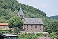
church

Elementary school in the Weiltal


Evangelical parish church from the 19th century
The history of the Protestant parish church above the village is largely unknown. The fortified, presumably Gothic west tower is the oldest part of the building. In 1891 the nave and choir were built. The organ was designed by Gustav Raßmann and dates from the following years.
The Martin Luther linden tree planted by the students and teachers of the parish of Rod an der Weil in honor of Martin Luther's 400th birthday in the following year 1884 is designated as a natural monument .

Oldest rectory in Germany from around 1200
The rectory of Rod an der Weil is one of the oldest still preserved rectory in Hesse and Germany. The inscription on the door beam indicates that it was built in 1522, the older parts of the building are estimated to be at the beginning of the 13th century. The upper two of the four floors are built in half-timbered construction. The building is reminiscent of a small fortress, so it also has a “machicolation” above the entrance. In times of war, the rectory also served as protection for the population. The site is currently being redesigned.
More half-timbered houses
There are also several restored half-timbered houses east of the Weil in the streets Schmiedhof and Klapperfeld. The old school in Rod an der Weil, Am Kirchberg has even been described as one of the most beautiful half-timbered properties in the Taunus newspaper. The old school was extensively renovated in 1998 and is now used for residential purposes.
Climbing quarry
At Rod an der Weil there is a climbing quarry in the district of Cratzenbach .
Infrastructure
Hiking trails
From Rod an der Weil several signposted hiking trails lead to the Eichelberg ( 397.1 m ) with the Rentmauer, along the Weil, to viewpoints above the Weiltal and to Emmershausen and Hasselbach. An ecological educational trail "Rentmauer" deals with the forest ecosystem and the local flora and fauna. In the headwaters of the Eichelbach just before the historic Rennstraße , there is the Eichelbacher Hof excursion restaurant , a former moated castle.
education
In Rod an der Weil there has been a central elementary school "auf dem Senner" since the 1970s . In 2006, after an international architectural competition , the school was replaced by a new building designed by the Frankfurt architect Bernd Mey . The new school building has already been selected twice as exemplary for the Architecture Day in Hesse .
Personalities
The former member of the Bundestag Holger Haibach (* 1971) comes from Rod an der Weil.
Web links
- District Rod an der Weil on the website of the community Weilrod.
- Rod an der Weil, Hochtaunuskreis. Historical local dictionary for Hessen. (As of March 28, 2014). In: Landesgeschichtliches Informationssystem Hessen (LAGIS).
- Literature about Rod an der Weil in the Hessian Bibliography
Individual evidence
- ↑ Rod an der Weil on the website of the community of Weilrod , accessed on March 25, 2018.
- ^ Marie-Luise Crone, Matthias Theodor Kloft, Gabriele Hefele (eds.): Limburg. History of the diocese. Éditions du Signe, Strasbourg 1995, p. 29. ISBN 2877180980
- ↑ Alexander Schneider: Who once splashed around in the eight bathing establishments; in: Taunuszeitung from June 19, 2018, p. 17.
- ^ Federal Statistical Office (ed.): Historical municipality directory for the Federal Republic of Germany. Name, border and key number changes in municipalities, counties and administrative districts from May 27, 1970 to December 31, 1982 . W. Kohlhammer GmbH, Stuttgart and Mainz 1983, ISBN 3-17-003263-1 , p. 379 .
- ↑ Law on the reorganization of the Obertaunus district and the district of Usingen (GVBl. II 330-18) of July 11, 1972 . In: The Hessian Minister of the Interior (ed.): Law and Ordinance Gazette for the State of Hesse . 1972 No. 17 , p. 227 , §§ 1 and 13 ( online at the information system of the Hessian state parliament [PDF; 1,2 MB ]).
- ↑ Map services of the Federal Agency for Nature Conservation ( information )

Altweilnau | Cratzenbach | Emmershausen | Dark Valley | Gemünden | Hasselbach | Mauloff | Neuweilnau | Niederlauken | Oberlauken | Riedelbach | Rod at the Weil | Winches