Rohrberg (Kaufunger Forest)
| Rohrberg | ||
|---|---|---|
| height | 535.6 m above sea level NHN | |
| location | near Hirschhagen , Werra-Meißner district , Hesse ( Germany ) | |
| Mountains |
Kaufunger Wald , Fulda-Werra-Bergland |
|
| Coordinates | 51 ° 14 '11 " N , 9 ° 42' 31" E | |
|
|
||
The Rohrberg is 535.6 m above sea level. NHN high mountain in the Kaufunger Forest in the north Hessian Werra-Meißner-Kreis ( Germany ). In the Fulda-Werra-Bergland it lies in the east of the Söhre, which adjoins the actual plateau of the Kaufunger Forest to the south .
geography
location
The Rohrberg rises in the Werra-Meißner district, although small parts of the lower areas of its west and northwest flanks are in the district of Kassel , and in the geo-nature park Frau-Holle-Land (Werratal.Meißner.Kaufunger forest) . Its summit is a maximum of about 1.5 km northeast to north of Hirschhagen , a district of Hessisch Lichtenau . The localities around the mountain include the core town of Helsa with its location in Hergesbachtal in the north-northwest, Rommerode (to Großalmerode ) in the east, Friedrichsbrück (to Hessisch Lichtenau) in the southeast, Fürstenhagen (located on the other side of Hirschhagen; to Hessisch Lichtenau) in the south and Eschenstruth with its location Waldhof (to Helsa) in the southwest to the west-southwest.
The neighbors of the Rohrberg, whose high elevations are partly unwooded, include the Buchberg ( 482 m ) in the north, the Hirschberg ( 643.4 m ) in the east-northeast, the Mühlberg ( Mühlenberg ; 441.3 m ) in the south, the Koppe ( 456 , 4 m ) in the southwest and the Bielstein ( 527.8 m ) in the northwest.
To the north past the Rohrberg the Hergesbach flows northwest, the Steinbach, which ultimately runs southwest, rises a little southeast of its summit, and the Rohrbach, which flows west-northwest on the high altitudes of Hirschhagen, rises to the southwest; they are all Losse tributaries.
Natural allocation
The Rohrberg belongs to the natural spatial main unit group Osthessisches Bergland (No. 35), in the main unit Fulda-Werra-Bergland (357) and in the subunit Kaufunger Wald und Söhre (357.7) to the natural area Söhre (357.70).
Explosives factory in Hessisch Lichtenau
The Hessisch Lichtenau explosives factory was built on the southwest and southern part of the Rohrberg in the area of today's Hirschhagen since 1936 , where TNT and picric acid have been produced and processed since 1938 and during World War II (1939–1945) and detonators and detonators with nitropenta delivered by forced laborers as well Concentration camp prisoners were filled. Because the production took place without considering the environment, the soil structure was extensively renovated between 1992 and 2008. Groundwater has to be treated further.
Transport links and hiking
Federal road 7 runs west and south-west past the Rohrberg in the Lossetal between Helsa and Hessisch Lichtenau . In the future, the extension of the Bundesautobahn 44 from Kassel to Herleshausen , which is currently partly in the planning and partly under construction, will run between the junction points Helsa-Ost and Hessisch Lichtenau-West , which will then run near Hirschhagen in the Rohrbergsüdwest- and Südflanke through the maximum of about 4, The Hirschhagen tunnel will be 2 km long . From the B 7, the Hirschhagener Straße branches off in Fürstenhagen , which after crossing the Kassel – Waldkappel ( Lossetalbahn ) railway line, which also runs through the river valley, will in future lead over the tunnel and has always served as a connection between Fürstenhagen and Hirschhagen and as an access road towards the Rohrberghochlagen serves. In Hessisch Lichtenau, a little south-east of the mountain, the B 7 branches off the state road 3225, which leads northeast to Friedrichsbrück , from which in turn the L 3400 leads northwest through the Hergesbachtal village of Helsa to Helsa; the latter passes the mountain in the northeast and north and has a connection to the B 7 in Helsa via the B 451 , so that you can bypass the mountain entirely.
You can reach the high elevations of the Rohrberg, to which no roads lead, for example coming from Hirschhagen on paths that run through partly wooded landscape.
Rohrberg wind farm

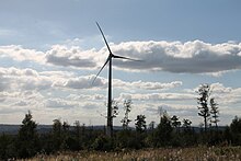
After a year-long wind measurement, Städtische Werke AG Kassel installed five ENERCON E-115 wind turbines with 3 megawatts each and a hub height of 149 m on the Rohrberg in late 2015 and early 2016 . The wind farm is operated by Windpark Rohrberg GmbH & Co. KG. The network operator is Städtische Werke Netz + Service GmbH.
Individual evidence
- ↑ a b Map services of the Federal Agency for Nature Conservation ( information )
- ^ Hans-Jürgen Klink: Geographical land survey: The natural space units on sheet 112 Kassel. Federal Institute for Regional Studies, Bad Godesberg 1969. → Online map (PDF; 6.9 MB)
- ↑ The first wind turbine on the Rohrberg is in place. In: hna.de. September 11, 2015, accessed January 9, 2016 .
- ↑ Home - Rohrberg wind farm. In: windpark-rohrberg.de. Retrieved January 9, 2016 .

