
Ryczów (Spytkowice)
| Ryczów | |||
|---|---|---|---|
_COA.jpg)
|
|
||
| Basic data | |||
| State : | Poland | ||
| Voivodeship : | Lesser Poland | ||
| Powiat : | Wadowice | ||
| Gmina : | Spytkowice | ||
| Geographic location : | 49 ° 59 ' N , 19 ° 33' E | ||
| Height : | 210-345 m npm | ||
| Residents : | 2620 (2016) | ||
| Postal code : | 34-115 | ||
| Telephone code : | (+48) 33 | ||
| License plate : | KWA | ||

Ryczów is a village with a Schulzenamt of the municipality Spytkowice in the powiat Wadowicki of the Lesser Poland Voivodeship in Poland .
geography
-mapa.jpg)
The place is on the right, southern bank of the Vistula . The neighboring towns are Spytkowice in the west, Lipowa in the north, Kamień in the northeast (behind the Vistula), Łączany in the east and Bachowice , Zygodowice and Tłuczań in the south.
history
The area between the rivers Skawa in the west and Skawinka in the east (with the exception of the Radwanite Corridor ) was separated from Lesser Poland in 1274 and attached to the Duchy of Opole . The Duchy of Opole was divided in 1281 after the death of Wladislaus I von Opole . From 1290 the area belonged to the Duchy of Teschen and from 1315 to the Duchy of Auschwitz , which was under the feudal rule of the Kingdom of Bohemia from 1327 .
The Tyniec Benedictines wrote a forgery between 1283 and 1286 claiming that u. a. the village villae nostri Ricow was given to the monastery in 1250 by Wladislaus I of Opole-Ratibor . According to other sources, 16 hooves in the local forest were awarded to the Mogila monastery by Duke Primislaus as early as 1284 . A similar lending was given in 1302 by Duke Mieszko I of Teschen-Auschwitz for the monks and two years later the Duke specified that the new Waldhufendorf was organized according to German law. However, neither document gave a name to the village, which did not reappear until 1329. The possessive name is derived from the personal name Rycz (for example mentioned in 1386 as Ricz ). The village is considered to be the only one founded by the Mogil Cistercians. The settlers probably came from other properties in the monastery. The monks later also bought Woźniki (1324), Zygodowice (1324-1329) and Półwieś (around 1450), but Ryczów remained the seat of the estates until the late 18th century. The oldest and most important parish, however, had its seat in Woźniki, with only branch churches in Ryczów, Zygodowice and the city of Wadowice (until 1780). The wooden church from the early 17th century is now in the open-air museum in Wygiełzów .
Since 1445 it belonged to the Duchy of Zator , which was sold to the Polish king in 1494. Subsequently, the Duchy of Auschwitz-Zator was completely attached to the Kingdom of Poland in 1564, as the district of Silesia in the Krakow Voivodeship , and from 1569 in the Polish-Lithuanian aristocratic republic .
During the first partition of Poland in 1772, Ryczów became part of the new Kingdom of Galicia and Lodomeria of the Habsburg Empire (from 1804). From 1782 it belonged to the Myslenice district (1819 with the seat in Wadowice ). After the abolition of patrimonial it formed a parish in the judicial district of Wadowice in the Wadowice District after 1850 , from 1891 in the Zator judicial district, which was merged with the Oświęcim judicial district in 1910 to establish the Oświęcim district .
In 1918, after the end of the First World War and the collapse of the Austro-Hungarian monarchy, Ryczów became part of Poland again. This was only interrupted by the occupation of Poland by the Wehrmacht in World War II .
From 1975 to 1998 Ryczów was part of the Bielsko-Biała Voivodeship .
traffic
The state road DK 44 , which connects Gliwice via Oświęcim with Kraków , and the railway line No. 94 (Oświęcim - Kraków Płaszów) run through Ryczów .
Attractions
- Palace of the Piasecki family, 19th century

New Church
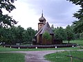
Wooden church from Ryczów in Wygiełzów

Palace in Ryczów


.jpg)
Web links
Individual evidence
- ^ Wojciech Kętrzyński , Stanisław Smolka : Kodeks dyplomatyczny klasztoru tynieckiego . Lwów 1875, p. XXXI (Latin, online ).
- ↑ A. Baran, 2014, p. 11
- ↑ a b c Paweł Mostowik: Z dziejów Księstwa Oświęcimskiego i Zatorskiego XII-XVI w . Toruń 2005, ISBN 83-7441-175-9 , Aneks. Miejscowości ziemi oświęcimsko-zatorskiej, p. 186 (Polish).
- ↑ A. Baran, 2014, p. 12
- ↑ Władysław Lubas: nazwy miejscowe Południowej części dawnego województwa Krakowskiego . Polska Akademia Nauk . Instytut Języka Polskiego, Wrocław 1968, p. 131 (Polish, online ).
- ↑ A. Baran, 2014, pp. 19-22
- ↑ Dz.U. 1975 no 17 poz. 92 (Polish) (PDF file; 783 kB)
literature
- Agnieszka Baran: Rola cystersów mogilskich w zagospodarowaniu terenu dawnego księstwa zatorskiego (XIII-XVII w.) [Estate Cistercian Abbey in Mogiła in Duchy of Zator (second half 13th century-first half of the 17th century.)] (= Wadegl . Century.)] -kulturalny ). 2014 (Polish, online [PDF]).
