Skawinka
| Skawinka | ||
|
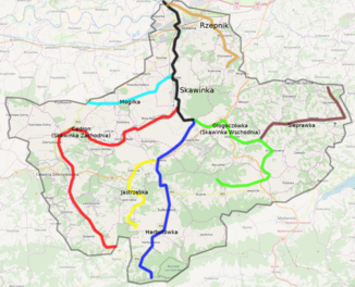
Catchment area |
||
| Data | ||
| location | Poland | |
| River system | Vistula | |
| Drain over | Vistula → Baltic Sea | |
| source | Traditional run: eastern slope of Mount Chełm, Skawinki , in the Central Beskids | |
| muzzle | in the Vistula near Skawina Coordinates: 49 ° 59 ′ 40 " N , 19 ° 47 ′ 44" E 49 ° 59 ′ 40 " N , 19 ° 47 ′ 44" E |
|
| Mouth height |
209 m above sea level NN
|
|
| length | 34 km | |
| Catchment area | 365 km² | |
| Medium-sized cities | Skawina | |
| Small towns | Kalwaria Zebrzydowska , Lanckorona | |
|
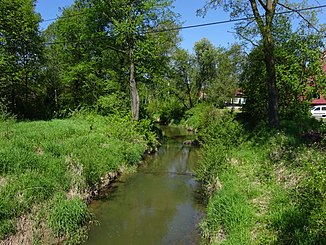
River Skawinka in Wola Radziszowska |
||
The Skawinka is a right tributary of the Vistula in southern Poland, the largest between Skawa and Raba . The catchment area covers 365 square kilometers. It flows into the Vistula at a height of 209 meters near Skawina. The main tributaries are: Mogiłka, Harbutówka, Głogoczówka, Włosanka, Lutówka, Rzepnik.
According to the definition of the Polish Commission for the Standardization of Geographical Names outside the borders of the Republic of Poland, the Harbutówka is the upper reaches of the Skawinka river to the mouth of the Głogoczówka, where the river takes the name Skawinka.
course
The Skawinka or Harbutówka rises on the slopes of the Babica in the Central Beskids at an altitude of 560 m. It flows north through Harbutowice , Sułkowice , Biertowice and Krzywaczka . On the border of Krzywaczka, Wola Radziszowska , Radziszów and Głogoczów , the Harbutówka joins the Głogoczówka (formerly also called Skawinka Wschodnia - Eastern Skawinka ) and takes the name Skawinka. The left tributary Cedronka (formerly Skawinka Zachodnia - Western Skawinka ) flows about two kilometers north .
Until the late 19th century, however, the course of the Skawinka was mostly determined differently: from its origin in the village of Skawinki on the eastern slope of Mount Chełm in the Central Beskids (603 m), its course first leads north between Leśnica in the west and Lanckorona in the east, then between Kalwaria Zebrzydowska on the left and Brody on the right bank. After Zebrzydowice , the Skawinka changes its course to the east and flows to the southern edge of Przytkowice . It then separates the villages of Leńcze and Podolany in the north from Zarzyce Wielkie and Zarzyce Małe in the south. It flows through Wola Radziszowska in a north-easterly direction. On its lower reaches in the north it first cuts through Radziszów , passes Rzozów in the east and then flows through Skawina . At the end, the Skawinka flows into the Vistula precisely at today's administrative border of Krakow , just under three kilometers south of the Tyniec Abbey .
history
The area between the Skawa rivers in the west and the traditionally understood course of the Skawinka in the east was separated from Lesser Poland in 1274 and connected to the Duchy of Opole (without the Radwanite Corridor ). Skawinka became the new border river between Silesia and Lesser Poland. The Duchy of Opole was divided in 1281 after the death of Ladislaus I of Opole . The part on the left bank came to the Duchy of Auschwitz , since 1327 under the feudal rule of the Kingdom of Bohemia . A few decades later, Casimir the Great had to renounce his rights to Silesia. At that time, this international border was only about 20 kilometers from the capital Krakow. This development caused the foundation of the town of Skawina in 1368 on the Polish bank of the river. Since 1445 the Silesian bank belonged to the Duchy of Zator ; this was sold to Poland in 1494 and the border status of the Skawinka lost its importance. In 1564 the duchies of Auschwitz and Zator were fully incorporated and annexed to the Krakow Voivodeship . The new state border ran not twenty, but about eighty kilometers southwest of the Polish capital.
Since the founding of the town, the monastery and the Calvary Kalwaria Zebrzydowska at the turn of the 16th to the 17th century, the approximately one kilometer long section of the river in this area is often referred to as Cedron .
In the late 19th century, the naming on the maps changed significantly due to bureaucratic decisions made by the Austrian cartographers, which led to the lack of clarity today. Harbutówka was renamed Skawinka on the maps, while the upper reaches from Skawinki village to Wola Radziszowska became Cedron. Today the naming is mixed; there are also maps and guidebooks that follow the traditional route that originated in Skawinki.
Web links
Individual evidence
- ↑ a b Karpackie dopływy Wisły ( pl )
- ↑ Wykaz wód płynących Polski .
- ↑ Julian Zinkow: Wokół Kalwarii Zebrzydowskiej i lanckorona . Wydawnictwo "CALVARIANUM", Kalwaria Zebrzydowska 2000, ISBN 83-8739541-2 , p. 301 (Polish).
- ↑ a b Skawinka - rzeką graniczną [Skawinka - a border river ] ( Polish )
- ↑ a b Julian Zinkow: Wokół Kalwarii Zebrzydowskiej i lanckorona . Wydawnictwo "CALVARIANUM", Kalwaria Zebrzydowska 2000, ISBN 83-8739541-2 , p. 217 (Polish).
- ↑ Małopolska. Mapa samochodowo-krajoznawcza . COMPASS, Krakow, ISBN 978-83-7605-179-6


