Oświęcim district
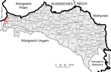
The Oświęcim district (rarely Auschwitz district ) was a political district in the crown land of Galicia and Lodomeria . Its area covered parts of western Galicia in what is now Poland ( Powiat Oświęcim ), the seat of the district administration was the city of Oświęcim . After the First World War , Austria had to cede the entire district to Poland, here large parts can be found today in the powiat Oświęcimski .
It bordered on the northwest by the German Empire , in the northeast on the district Chrzanów , in the southeast of the district Wadowice , and on the southwest by the district Biala .
history
The district emerged late in the course of the administrative history of Galicia, specifically it was created on July 1, 1910 when the judicial district of Oświęcim (Auschwitz) left the Biała district and the Zator judicial district from the Wadowice district.
The Oświęcim district consisted of 46 municipalities and 34 manor areas in the 1910 census and covered an area of 336 km². In 1900 the population had still comprised 42,254 people, in 1910 49,996 people lived here. The majority of the people living in the area spoke Polish (97%) and had Roman Catholic beliefs, while Jews made up around 13% of the population.
Localities
In 1910 there were district courts in Oświęcim (Auschwitz) and Zator , and the following locations were assigned to them:
Oświęcim judicial district (Auschwitz):
- Babice
- Broszkowice
- Brzeszcze
- Brzezinka
- Dwory
- Grojec
- Harmęże
- Jawiszowice
- Klucznikowice
- Kruki
- Łazy
- Monowice
- City of Oświęcim (Auschwitz)
- Pławy
- Polanka Wielka
- Poreba Wielka
- Przecieszyn
- Rajsko consisting of the districts Budy and Rajsko
- Skidzin
- Stare Stawy
- Wilczkowice
- Włosienica
- Zaborze
Zator judicial district:
See also
Individual evidence
- ^ Reichs-Gesetz-Blatt for the Empire of Austria. Born in 1910, XLI. Piece, No. 110: "Announcement of the Ministry of the Interior of May 31, 1910"
- ^ The results of the census of December 31, 1910 in the kingdoms and countries represented in the Imperial Council - the summary results of the census. With 6 cartograms - Table I.
- ^ The results of the census of December 31, 1910 in the kingdoms and countries represented in the Imperial Council - the summary results of the census. With 6 cartograms - Table II.
- ^ The results of the census of December 31, 1910 in the kingdoms and countries represented in the Imperial Council - the summary results of the census. With 6 cartograms - Table III.
- ^ General directory of the local communities and localities in Austria based on the results of the census of December 31, 1910, page 361
literature
- Christian Andreas Steiner: The territorial development of the administration and the jurisdiction in the kingdoms of Galicia and Lodomeria from 1848-1918. Diploma thesis Graz, 2012
- kk Central Statistical Commission (Hrsg.): Special-Orts-Repertorium of the kingdoms and countries represented in the Austrian Reichsrat. Revised based on the results of the census of December 31, 1890. Vienna 1893
- kk Central Statistical Commission (Ed.): Community encyclopedia of the kingdoms and countries represented in the Reichsrat. Edited on the basis of the results of the census of December 31, 1900. XII. Galicia , Vienna 1907

