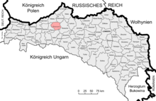
Ropczyce district
The district of Ropczyce was a political district in the crown land of Galicia and Lodomeria . Its area covered parts of western Galicia in what is now Poland ( Powiat Ropczyce-Sędziszów ), the seat of the district administration was the city of Ropczyce . After the First World War , Austria had to cede the entire district to Poland, here large parts can be found today in the powiat Ropczycko-Sędziszowski .
It bordered on the north by the district Mielec , in the northeast on the district Kolbuszowa , on the east by the district Rzeszów , on the south by the district Strzyżów and the west by the district Pilzno .
history
After the district offices were abolished at the end of October 1865 and their competencies were transferred to the district offices , the division of the country into two administrative areas was also abolished after the Austro-Hungarian Compromise in 1867. In addition, in the course of the separation of the political from the judicial administration, separate administrative and judicial authorities were created. While the judicial division remained largely unaffected, municipalities of several judicial districts were combined into administrative districts.
The new political district of Ropczyce was formed from the following districts:
- Ropczyce District (with 29 municipalities)
- Parts of the Kolbuszów district (Boreczek, Białybór municipalities with Blizne, Cierpisz, Czarna, Hucisko, Huta, Kamionka, Leszcze, Niwiska, Ociekam with Wola and Dąbie, Poręby, Ruda, Tuszyma, Trześnia and Zapole)
- Parts of the Frysztak district (municipalities Jaszczurowa, Julkowice, Kalembina, Korzuchów, Niewodna, Rożanka, Szufnarowa, Wiśniowa with Jezowa and Zawadka)
- Parts of the Dembica district (municipalities Brzezówka, Lubzina, Łopuchowa, Mała, Niedźwiada, Okonin, Ostrów, Paszczyn, Sepnica with Słustowa and Skrzyszów municipalities)
- Parts of the Rzeszów district (municipalities Będziemysl, Dąbrowa, Kawęcin with Księżymost, Klęczany, Krzywa, Olchowa with Lipie, Przedmieście with Podlasek, Sędziszów market, Sielec, Trzciana, Wolica Ługowa, Wolica Piaskowa)
In the 1910 census, the Ropczyce district consisted of 91 municipalities and 61 manor areas and covered an area of 800 km². In 1900 the population had still comprised 78,480 people, in 1910 80,170 people lived here. The majority of the people living in the area spoke Polish (99.4%) and Roman Catholic faith, Jews made up around 9% of the population.
Localities
In 1910 there were district courts in Dębica and Ropczyce on the territory of the district, and the following locations were assigned to them:
Dębica judicial district:
- Bobrowa consisting of the districts Bobrowa and Wola Bobrowska
- Brzeźnica consisting of the districts Brzeźnica and Wola Brzeźnicka
- Brzeźowka consisting of the districts Brzeźowka and Tłustowa
- City of Dębica
- Paszczyna consisting of the districts Kochanówka and Paszczyna
- Podgrodzie consisting of the districts Grabówka and Podgrodzie
- Pustków consisting of the districts Męciszów , Pustków and Wola Pustkowska
- Pustynia consisting of the districts Kendzierz , Kozłów and Pustynia
Ropczyce judicial district:
- Iwierzyce consisting of the districts Iwierzyce and Olimpów
- The town of Ropczyce consists of the districts Gryfów , Ropczyce and Średnie
- Sędziszów Market
- Wielopole market
See also
Individual evidence
- ^ Reichs-Gesetz-Blatt for the Austrian Empire 1865, XXVI. Piece, No. 92: "Ordinance of the State Ministry of September 23, 1865, on the repeal of the district authorities in Galicia"
- ^ Reichs-Gesetz-Blatt for the Empire of Austria. Born in 1868, XVII. Piece, No. 44. "Act of May 19, 1868 on the establishment of political administrative authorities in the kingdoms ..."
- ^ Reichs-Gesetz-Blatt for the Empire of Austria. Born in 1867, XVII. Piece, No. 37: "Ordinance of the Ministry of Justice of February 15, 1867, on the establishment of purely district courts in Eastern Galicia"
- ^ Reichs-Gesetz-Blatt for the Empire of Austria. Year 1867, IX. Piece, No. 17: "Ordinance of the State Ministry of January 23, 1867"
- ^ The results of the census of December 31, 1910 in the kingdoms and countries represented in the Imperial Council - the summary results of the census. With 6 cartograms - Table I.
- ^ The results of the census of December 31, 1910 in the kingdoms and countries represented in the Imperial Council - the summary results of the census. With 6 cartograms - Table II.
- ^ The results of the census of December 31, 1910 in the kingdoms and countries represented in the Imperial Council - the summary results of the census. With 6 cartograms - Table III.
- ↑ General list of local parishes and localities in Austria based on the results of the census of December 31, 1910, page 371
literature
- Christian Andreas Steiner: The territorial development of the administration and the jurisdiction in the kingdoms of Galicia and Lodomeria from 1848-1918. Diploma thesis Graz, 2012
- kk Central Statistical Commission (Hrsg.): Special-Orts-Repertorium of the kingdoms and countries represented in the Austrian Reichsrat. Revised based on the results of the census of December 31, 1890. Vienna 1893
- kk Central Statistical Commission (Ed.): Community encyclopedia of the kingdoms and countries represented in the Reichsrat. Edited on the basis of the results of the census of December 31, 1900. XII. Galicia , Vienna 1907

