Sædden Sogn
| Sædden | ||||
|
||||
| Basic data | ||||
|---|---|---|---|---|
| State : |
|
|||
| Region : | Syddanmark | |||
|
Municipality (since 2007) : |
Esbjerg | |||
| Coordinates : | 55 ° 30 ' N , 8 ° 24' E | |||
| Founded: | 1978 | |||
|
Population : (2020) |
10,326 | |||
| Postal code : | 6710 Esbjerg | |||
 Location of Sædden Sogn in Esbjerg Municipality |
||||
Sædden Sogn is a parish municipality ( Danish : Sogn ) in Esbjerg in southern Denmark . It was created on August 1, 1978 by splitting off from the Guldager Sogn . It was therefore in the area of Harde Skast Herred in the former Ribe Office and belonged to Esbjerg Municipality in the expanded Ribe Office , which was merged into the "new" Esbjerg Municipality in the Syddanmark region on January 1, 2007 as part of the municipal reform .
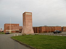
Of the 72,037 inhabitants of Esbjerg, 10,326 live in the parish of Sædden (as of January 1, 2020). In the parish is the towerless church "Sædden Kirke", also called " Sædding Kirke" after the district in which it is located , with the rune stone DR 49, DK SJy 16.
Neighboring communities are in the north-west Hjerting Sogn , in the north Guldager Sogn , in the east Gjesing Sogn and in the south Treenigheds Sogn ( German : Dreieinigkeits -gemeinde ). In the west the parish borders the Wadden Sea with a view of the northern tip of Fanø .
Individual evidence
- ↑ a b Statistics Banks -> Befolkning og valg -> KM1: Befolkningen January 1st, April 1st, July 1st and October 1st, so og folkekirkemedlemsskab (Danish)
- ↑ Statistics banks -> Befolkning og valg -> BY1: Folketal January 1st efter byområde, alder og køn (Danish)


