Dubrovnik-Neretva County
|
Dubrovnik-Neretva County Dubrovačko-neretvanska županija |
|||||
|
|||||
| map | |||||
|---|---|---|---|---|---|
| Basic data | |||||
| State : |
|
||||
| Seat : | Dubrovnik | ||||
| Area : | 1,781 km² | ||||
| Residents : | 122,568 ( 2011 ) | ||||
| Population density : | 69 inhabitants per km² | ||||
| Biggest City : | Dubrovnik | ||||
| Telephone code : | 020 | ||||
| ISO 3166-2 : | HR-19 | ||||
| NUTS3 code4 : | HR037 | ||||
| Coordinates | 42 ° 39 ′ N , 18 ° 6 ′ E | ||||
| Structure and administration (as of 2013) |
|||||
| Cities : | 5 | ||||
| Municipalities : | 17th | ||||
| Settlements : | 231 | ||||
| Gespan : | Nikola Dobroslavić ( HDZ ) | ||||
| Coalition partner : | HSU, HSLS, HSP AS | ||||
| Postal address : | Gundulićeva poljana 1 20 000 Dubrovnik |
||||
| Website : | |||||
The Dubrovnik-Neretva County [ ˈdubrɔ̞ːʋnik ˈnɛrɛtʋa ] ( Croatian Dubrovačko-neretvanska županija ) is a county in the Croatian region of Dalmatia . It has an area of 1,781 km² and a population of 122,568 (2011 census). The administrative seat is in Dubrovnik .
geography
The county comprises the southernmost part of Dalmatia around the city of Dubrovnik as well as the area of the Neretva estuary , the Pelješac peninsula and the islands of Korčula , Mljet and Lastovo . In the east it borders on Bosnia and Herzegovina and in the extreme southeast on Montenegro .
The mainland territory of the county is divided into two parts by a short stretch of coast near Neum , the Neum corridor belonging to Bosnia-Herzegovina . The southern part around Dubrovnik has no direct land connection to the rest of the Croatian state territory and thus forms an exclave of Croatia.
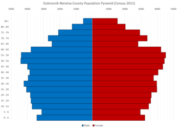
population
Composition of the population of the Dubrovnik-Neretva county by ethnicity census of 2011 :
| Ethnicity | number | percent |
|---|---|---|
| Croatians | 115,668 | 94.37% |
| Serbs | 2,095 | 1.71% |
| Bosniaks | 1,978 | 1.61% |
| Albanians | 408 | 0.33% |
| Montenegrins | 307 | 0.25% |
| Slovenes | 161 | 0.13% |
cities and communes
The Dubrovnik-Neretva County is divided into 5 cities and 17 municipalities. These are listed below with the population at the time of the 2011 census.
Cities
| city | Pop. |
|---|---|
| Dubrovnik | 42,615 |
| Korčula | 5,663 |
| Metković | 16,788 |
| Opuzen | 3,254 |
| Ploče | 10.135 |
Communities
| local community | Pop. |
|---|---|
| Blato | 3,593 |
| Dubrovačko primorje | 2,170 |
| Janjina | 551 |
| Konavle * | 8,577 |
| Kula Norinska | 1,748 |
| Lastovo | 792 |
| Lumbarda | 1,213 |
| Mljet | 1,088 |
| Orebić | 4.122 |
| Pojezerje | 991 |
| Slivno | 1999 |
| Smokvica | 916 |
| Ston | 2,407 |
| Trpanj | 721 |
| Vela Luka | 4.137 |
| Zažablje | 757 |
| Župa dubrovačka | 8,331 |
* Konavle Municipality comprises several smaller settlements south of Dubrovnik. A place called “Konavle” does not exist in this sense.
Infrastructure
In November 2005, preparatory work began on the longest bridge in Croatia (2,300 m), which is intended to bypass the Bosnian-Herzegovinian territory. The bridge leads from the coast southeast of Ploče over the Neretva Canal ( Neretvanski kanal ) to the Pelješac peninsula . The construction of the bridge has been interrupted several times, most recently in September 2011 with little budget. Should it be completed, the A1 Zagreb - Split - Dubrovnik motorway could also run over this bridge, but a motorway corridor through Neum on the mainland is also an alternative .
Web links
- http://www.edubrovnik.org/ Dubrovnik-Neretva County


