
Sachsenhausen (Waldeck)
|
Sachsenhausen
City of Waldeck
|
|
|---|---|
.png) |
|
| Height : | 372 m above sea level NHN |
| Area : | 24.85 km² (with Selbach) |
| Residents : | 1837 (Sep. 30, 2015) |
| Population density : | 74 inhabitants / km² |
| Incorporation : | 1st October 1971 |
| Postal code : | 34513 |
| Area code : | 05634 |
.jpg) View of Sachsenhausen
|
|
Sachsenhausen ( ) is the largest district in terms of population in the city of Waldeck in the Waldeck-Frankenberg district in northern Hesse .
geography
location
Sachsenhausen is about 35 kilometers west of Kassel . In the east is Freienhagen . The Edersee extends around six kilometers south of Sachsenhausen . The place is no longer in the Kellerwald-Edersee Nature Park .
landscape
The immediate area is hilly and little forested. The place is located in a slight depression that slopes down to the south. It is surrounded by fields and meadows. Several springs in the area feed the Klingebach , which almost circles the Klinger Berg south of the village through a picturesque valley. In the valley it passes the Klinger Klippen, a formation of limestone cliffs, and flows into the Reiherbach at Nieder-Werbe a few hundred meters before it flows into the Edersee . The Klingebachtal was designated as an FFH protected area (fauna, flora, habitat) by the state of Hesse as part of the EU Natura 2000 program. The Reiherbachtal stretches from Selbach in a south-easterly direction to Nieder-Werbe, where the Reiherbach flows into the Edersee.
history
Middle Ages and early modern times
Count Adolf I von Waldeck (1228–1270), who in 1246 granted the place city rights, is considered the founder of the city of Sachsenhausen . The city received market rights and its own jurisdiction. The seal from 1270 shows a knight with the star of Waldeck on the shield. Presumably, the lilies are a symbol of justice and indicate one's own jurisdiction . This remained the motif of the city's coat of arms until 1971. The town church of St. Nikolaus was built between 1292 and 1296.
The immigration of Jewish residents began around 1770. The Jewish community existed until 1942.
The medieval Sachsenhausen was surrounded by a city wall with ditches and towers, which was sold for demolition in 1856 and almost completely razed. A few years later, parts of the demolition material were used in the construction of the synagogue. On the city map you can still see the oval layout and the earlier course of the city wall. In the place of the former lower gate of the city wall, a plaque shows a map of the place around 1520.
Further data from the city's history:
- In 1472 a hospital was founded; the building was demolished in 1968.
- In 1533, with the introduction of the Reformation in the county of Waldeck, all residents became Protestant.
- The first pharmacy opened in 1809.
- The town hall was completed in 1817.
- 1953 was the completion of the new school (today elementary school).
- In 1969 the center school was completed.
As part of the regional reform that came into force on October 1, 1971, the community of Sachsenhausen was incorporated into the town of Waldeck. and their administrative headquarters.

Seal of the city of Sachsenhausen 1270

Coat of arms of the city of Sachsenhausen until 1971
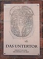
Plaque Sachsenhausen - Untertor
_1270.png)

Churches


Evangelical Church of St. Nicholas
Most of the population is Protestant. The town church of St. Nikolaus , built in the years 1292–1296, is in the center of the village.
Former synagogue
The synagogue was built in 1863 by the then Jewish community. Almost all Jews from Sachsenhausen fled or were deported during the National Socialist era. The synagogue was then used as a warehouse and was largely preserved. From 1947 to 1960 the building was used as a place of worship by the Catholic community and demolished in 1962 when the road was widened.
St. Boniface Church
Before the Second World War there were only three Catholic families in the Sachsenhausen parish area. During and after the war, many evacuees and displaced persons came to Sachsenhausen and the neighboring communities. They first celebrated their services in the Protestant St. Nicholas Church until the former synagogue was initially rented by the Catholic parish of Korbach in 1947 and bought in 1949 and used as a Catholic church. At the end of 1959, construction work began on the Catholic St. Bonifatius Church, which was inaugurated in 1960. The lintel above the sacristy entrance comes from the former synagogue; it bears the Hebrew inscription : "House Jacob, come let us walk in the light of Him". (Isias 2,5).
Evangelical Community Sachsenhausen
The parish hall of the "Evangelical Community Sachsenhausen", an independent Protestant community, is located in Gartenstrasse.
Attractions
- City Church of St. Nicholas (1296)
- Town Hall (1817)
- Sachsenhausen Control Center
- The control room, actually Rollborner Warte , is the only surviving one of the three medieval waiting towers that were built to protect themselves against raids and attacks by looting mercenaries or enemy troops. The tower has remained essentially unchanged. It can be climbed using crampons. From the top you have a nice view over Sachsenhausen. In the west you can see the Waldeck Upland , in the south-east you can see Waldeck Castle .
- Ruins of the Klinger Church
- The ruin bears witness to the submerged place Klingen, southeast of Sachsenhausen. With the exception of the west gable, only the foundation walls are preserved up to a height of about 1.50 m.

City Church of St. Nicholas

St Nicholas chancel

town hall

"Rollborner" wait

Ruins of the Klinger Church

Ruin Klinger Church - foundation walls
_St.Nikolaus.jpg)

_Rathaus.jpg)
_Warte.jpg)
_Klinge_church_ruin.jpg)
_DSCF1549_-_%C2%A9gl_2008.jpg)
Sports
- Whitsun contest: On the "Schiebenscheid" - every two years with jumping competitions up to class "S"
- Tennis club TC88 Sachsenhausen with a 3-court tennis facility behind the center school
- Schützengesellschaft 1604 Sachsenhausen eV
Economy and Infrastructure
Sachsenhausen is very rural. Some craft and service companies have settled. There are two bank branches, a petrol station, a pharmacy, various retail and grocery stores and a few restaurants in the village.
traffic
Sachsenhausen is on federal highway 251 . The B 485 runs through the village. The next train station is in Korbach (13 km). The Bad Wildungen-Korbach ( Ederseebahn ) railway line, which was closed in 1995 , passed via Sachsenhausen. Today there is a cycle path on the old route.
Public facilities
Sachsenhausen is the seat of the administration of the city of Waldeck . All offices are housed in the historic town hall on the market square. The city library is located next to the church. There is a municipal kindergarten as well as a primary school and a secondary and secondary school in the village.
Personalities
- Johannes Christian Ebersbach (1799–1862), Mayor of Sachsenhausen and Waldeckscher Landstand
- Friedrich Wilhelm Ebersbach (1805–1847), German lawyer and Waldeck country estate
- Wilhelm Ebersbach (1824-1891), German economist and Waldeck member of the state parliament, mayor of Sachsenhausen 1867-1882
- Carl Hartmann (1853–1925), member of the state parliament
- Charlotte Teske (* 1949), long-distance runner
Individual evidence
- ↑ a b The location on the city of Waldeck's website , accessed in February 2016.
- ↑ Natura 2000- FFH ( Memento of the original dated February 28, 2009 in the Internet Archive ) Info: The archive link was inserted automatically and has not yet been checked. Please check the original and archive link according to the instructions and then remove this notice.
- ↑ FFH data sheet ( Memento of the original from March 26, 2014 in the Internet Archive ) Info: The archive link was inserted automatically and has not yet been checked. Please check the original and archive link according to the instructions and then remove this notice.
- ↑ FFH card ( Memento of the original from March 26, 2014 in the Internet Archive ) Info: The archive link has been inserted automatically and has not yet been checked. Please check the original and archive link according to the instructions and then remove this notice. (PDF; 745 kB).
- ↑ Magistrate of the City of Waldeck, Festival Committee 750 Years of the City of Sachsenhausen: Sachsenhausen - 750 Years of City Rights. Contributions to the past and present. Waldeck-Sachsenhausen 1995.
- ^ Federal Statistical Office (ed.): Historical municipality directory for the Federal Republic of Germany. Name, border and key number changes in municipalities, counties and administrative districts from May 27, 1970 to December 31, 1982 . W. Kohlhammer GmbH, Stuttgart and Mainz 1983, ISBN 3-17-003263-1 , p. 408 .
- ^ History of St. Nicholas
Web links
- The place on the website of the city of Waldeck
- Sachsenhausen, Waldeck-Frankenberg district. Historical local dictionary for Hessen. In: Landesgeschichtliches Informationssystem Hessen (LAGIS).
- Literature about Sachsenhausen in the Hessian Bibliography
_COA.svg)