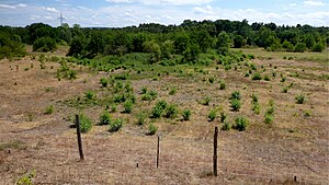
Sand pit in Dreispitz-Mörsch
|
Sandgrube nature reserve in Dreispitz-Mörsch
|
||
|
Sandgrube nature reserve in Dreispitz-Mörsch |
||
| location | Rheinstetten , Karlsruhe district , Baden-Wuerttemberg , Germany | |
| surface | 33.8 ha | |
| Identifier | 2197 | |
| WDPA ID | 165310 | |
| Geographical location | 48 ° 57 ' N , 8 ° 19' E | |
|
|
||
| Setup date | 17th August 1995 | |
| administration | Karlsruhe Regional Council | |
The sand pit in the three-cornered hat-Mörsch is a nature reserve in the natural area Northern Upper Rhine lowland in Baden-Wuerttemberg .
geography
The nature reserve is located in the municipality of Rheinstetten . It includes along with the little later under a conservation reserve Allmend fields on either side of the railway line Rastatt-Karlsruhe the area of the former Trockenbaggerung on Epplesee , a small portion of the bank itself, including the wet transition regions and east of subsequent sections of the Forchheimer Hardtwald .
history
The entire area of the former dry dredging, which was discontinued in the 1980s, was placed under protection. The rich biotope spectrum of the sand pit is an ideal secondary alternative biotope for many animal species that have adapted to the former drifting sand and inland dunes.
geology

This pit is located in the middle of the former drift sand and dune areas between the Rhine and the Kinzig-Murg-Rinne, which are used for agriculture today. The lime-free, gravelly sands deposited on the lower terrace of the Rhine are of interest to the construction industry. The surfaces are only slightly covered with topsoil.
description
The area was designated as a nature reserve by ordinance on August 17, 1995 by the Karlsruhe Regional Council and has an area of around 34 hectares. It is listed under the protected area number 2.197 and is classified in IUCN Category IV, a biotope and species protection area. The CDDA code is 165310 and also corresponds to the WDPA ID .
The main protection purpose is to secure the sand pits as pioneer locations from the moist to the extremely dry area, the protection and promotion of the successional stages of the vegetation on the different locations, as well as the protection and promotion of the structural diversity of the sand pits, their steep slopes and elevations as habitat of the an fauna and flora adapted to these extreme locations, especially specialized and endangered bird and insect species as well as felt herbs.
Flora and fauna
The number of insect and bird species recorded so far is above average for the natural area and of supraregional importance.
For example , little ringed plover , brown pipit and wheatear were found in the area. A sand martin colony has been at home in the steep, sandy slope embankments for many years .
See also
- List of nature reserves in Baden-Württemberg
- List of nature reserves in the district of Karlsruhe
- List of natural spatial units in Baden-Württemberg
literature
- District Office for Nature Conservation and Landscape Management Karlsruhe (Ed.): The nature reserves in the administrative district of Karlsruhe . Thorbecke, Stuttgart 2000, ISBN 3-7995-5172-7
Web links
- Profile of the nature reserve in the LUBW's list of protected areas
Individual evidence
- ↑ Map services of the Federal Agency for Nature Conservation ( information )
- ↑ § 3 Protection purpose ordinance of the Karlsruhe Regional Council of August 17, 1995, accessed on December 15, 2015
- ↑ [1] Appreciation of the nature reserve "Sandgrube im Dreispitz-Mörsch" from 1990, accessed on December 15, 2015


