
Weingartener Moor
|
Nature reserve Weingartener Moor-Bruchwald Grötzingen
|
||
 Start of the circular route on the Weingartener Moor |
||
| location | Germany , Baden-Wuerttemberg , Karlsruhe , Weingarten (Baden) | |
| surface | 2.556 km² | |
| Identifier | 2017 | |
| WDPA ID | 166229 | |
| Geographical location | 49 ° 2 ' N , 8 ° 31' E | |
|
||
| Setup date | October 11, 1940 | |
| administration | Karlsruhe Regional Council | |

The Weingarten Moor (officially NSG Weingarten Moor Bruchwald Grötzingen ) is a nature reserve in the country - and the city district of Karlsruhe . The moor is a low moor with open water surfaces.
history
After the rivers Kinzig and Murg broke through into the Rhine around 7,000 years ago, the former river bed became marshy and moor areas formed, including the Weingartener Moor. Some of the moor has a very high groundwater level. It was designated as a nature reserve on October 11, 1940, as the area was endangered by peat extraction. The surrounding quarry forest and part of the Grötzinger Baggersee followed on July 27, 1984.
Location and purpose of protection
The 256 hectare nature reserve lies between Weingarten and Grötzingen and is the largest fen still in existence today in the eastern rim of the Upper Rhine lowlands. It is located in the Kinzig-Murg-Rinne west of the federal highway 3 . 149 hectares of the protected area are located in Karlsruhe, the rest belongs to Weingarten. In terms of the natural spatial allocation, the protected area belongs to the natural spatial unit 223 - Hardtebenen within the main unit 22 - Northern Upper Rhine Lowland .
The main protective purpose is the preservation of the remains of a fens with large stocks of sedge and reed and the surrounding swamp forest with characteristics of the hornbeam forest, the alder-ash forest and the pure alder quarry as well as the northeast half of the Grötzinger quarry pond with its near-natural bank areas as a habitat for numerous endangered amphibians, Insect and bird species.
Numerous endangered amphibian, insect and bird species live in the bog. In the past, many animals were run over during amphibian migration through the B3 to the east; today an amphibious tunnel was set up under the road .
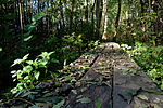
Wooden planks on the paths through the Weingartener Moor

Viewing platform on the lake in the Weingartener Moor

Lake in the Weingartener Moor


The quarry forest consists of black alder quarry forest , bird cherry-alder-ash forest, forest ziest-hornbeam-pedunculate oak forest and hornbeam-pedunculate oak forest.
The moor is registered as a geotope under the name Weingartener Moor-Bruchwald Grötzingen .
See also
literature
- District Office for Nature Conservation and Landscape Management Karlsruhe (Ed.): The nature reserves in the administrative district of Karlsruhe . Thorbecke, Stuttgart 2000, ISBN 3-7995-5172-7
- Klaus Geggus and Hubert Daul: Weingartener Moor, Ungeheuerklamm and natural monuments on the outskirts of Weingarten (Baden) . In: Bürger- und Heimatverein Weingarten eV (Hrsg.): Local history publications . DG Druck GmbH, Weingarten 2017.
Web links
- Profile of the nature reserve in the LUBW's list of protected areas
- Geotope profile on the map server of the State Office for Geology, Raw Materials and Mining (LGRB) (download link)
Individual evidence
- ↑ Weingartener Moor nature reserve and wet biotope. In: Website of the community of Weingarten. Retrieved April 19, 2019 .
- ↑ Nature guide Karlsruhe: Bruchwald ( page no longer available , search in web archives ) Info: The link was automatically marked as defective. Please check the link according to the instructions and then remove this notice. . Environment Agency City of Karlsruhe, 2nd edition 2000.
- ↑ The Weingartener Moor - Bruchwald Grötzingen . Ministry for the Environment, Nature Conservation and Transport Baden-Württemberg.
- ↑ a b Ordinance of the Karlsruhe regional council on the nature reserve "Weingartener Moor - Bruchwald Grötzingen". In: Website of the city of Karlsruhe. Retrieved April 19, 2019 .
- ↑ a b c Weingartener Moor-Bruchwald Grötzingen. In: Website of the city of Karlsruhe. February 1, 2012, accessed April 19, 2019 .


Alb valley and side valleys | Allmendäcker | Old Rhine Little Lake Constance | Old Rhine Neuburgweier | Altrhein-Koenigsee | Apple mountain | At Reutwald | At the Red Cross | Break near Stettfeld | Erlich | Federbachbruch between Muggensturm and Malsch | Won France-Wiesental | Glasbächle, Krebsbächle and Farlickwiesen | Greifenberg | In the upper crack | Kaiserberg | Kälberklamm and Hasenklamm | Little Kraichbach | Kohlbachtal and adjacent areas | Cabbage slab | Kraichbach and Weiherbachaue | Kraichbach lowlands | Clay pit at Heulenberg | Malscher Aue | Michaelsberg and Habichtsbuckel | Manure meadows | Oberbruchwiesen | Östringer Alder Forest | Pfinzquellen | Rhine valley between Au am Rhein, Durmersheim and Rheinstetten | Broken Knight | Rotenberg | Rußheimer Altrhein-Elisabethenwört | Sand pit in Dreispitz-Mörsch | Seelachwiesen | Clay pit Gochsheim | Monsters Gorge | Wagbach lowlands | Weingartener Moor-Bruchwald Grötzingen | Wilhelmsäcker | Twelve mornings
