
Hem tip
| Hem tip | ||
|---|---|---|
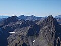
 Saumspitze (left) and Seeköpfe / Seespitz (right) seen from the Kuchajoch |
||
| height | 3039 m above sea level A. | |
| location | Tyrol , Austria | |
| Mountains | Verwall group | |
| Dominance | 0.7 km → Seeköpfe | |
| Notch height | 198 m ↓ Schneidjöchli | |
| Coordinates | 47 ° 3 '3 " N , 10 ° 16' 12" O | |
|
||
| Normal way | St. Anton am Arlberg - Darmstädter Hut - Saumspitze | |

The Saumspitze (in Alpenvereinskarte even Saumspitz is called) a 3039 m above sea level. A. high mountain in the Verwall group in Austria between St. Anton am Arlberg and Ischgl . From both places you walk to the Darmstädter Hütte in 4 to 5 hours , from where you can see the mountain and the route described below. Several routes of difficulty I to II lead to the summit .
From the hut you follow the Hoppe-Seyler-Weg , which leads to the Niederelbehütte , to below the Schneidjöchl (2841 m). You leave the path at about 2720 m to the left and orientate yourself on the markings and mostly clear climbing tracks that lead over a craggy ridge and a debris dump into the southwest flank of the mountain. Finally through rocks to the summit with a cross and a book, which can be reached after about 3 hours from the hut.
An artfully assembled stone arch has stood on the slightly lower south-east summit for years.
view
The Saumspitze offers a far-reaching, almost all-round view, which is only somewhat restricted by the nearby lake heads to the south and the massif of Kuchen- and Küchlspitze (which covers the Bernese Alps ) to the west- south- west. Among other things, you can see the Ötztal Alps in the east almost in their entire north-south extent. The glaciated Ortler Alps are striking in the south-southeast . To the right of the lake heads, the view extends to the Bernina group , further to the southwest , e.g. to the Silvretta , Pizzo Tambo and Rheinwaldhorn , and with good visibility as far as the Valais ( Weismies , 201 km, Alphubel , 215 km away).

View from the Saumspitze to the Kartell reservoir

View from the southeast summit of the Saumspitze to the Wildspitze

View of the nearby lake heads, to the left behind the Fluchthorn . On the right on the horizon the Bernina , on the far right Silvretta with Piz Buin and Piz Linard
Faselfadspitze front right, Scheibler left center. Between the two mountains, the Pflunspitzen and Kaltenberg . Red wall on the far right.


swell
- Peter Pindur, Roland Luzian, Andreas Weiskopf: Alpine Club Leader Verwall Group . Bergverlag Rother , 10th edition, 2005, ISBN 3-7633-1251-X
Individual evidence
- ↑ a b AV card 28/2 Verwallgruppe Mitte, 3rd edition 2009, ISBN 978-3-928777-36-0
- ↑ PeakFinder Ltd [email protected]: Mountain panorama: Saumspitze. Retrieved February 11, 2020 .