Rhine canal

Rheinseitenkanal is the common German name of the French Grand Canal d'Alsace ( French for literally large Canal of Alsace , in the Rhine Navigation Police Ordinance also Great Alsatian Canal , in translations of the Versailles Treaty and other treaties between France and Germany also a side canal ), a western or The shipping canal running to the left of the Rhine between Village-Neuf (F) at the southern end and Volgelsheim (F) in the north or Weil am Rhein - Märkt (D) and Breisach (D).
The national border between Germany and France runs between Märkt and Breisach in the valley path of the Rhine, which runs parallel to the east or to the right of the canal, here usually referred to as the “rest” or “ old Rhine ”.
history
After the German Reich lost the First World War , the territory of the Reichsland Alsace-Lorraine was annexed to France again in accordance with the Versailles Treaty in 1919 . As a result, the Rhine in the section between Basel and Lauterbourg became the state border between Germany and France again. In addition, Article 358 of the Versailles Treaty granted France the sole right to discharge any water from the Rhine and to use the hydropower of the Rhine in the border section. Half of the electricity generated should be credited to Germany. Taking advantage of this contractual clause, France began to plan and build a canal west of the section of the Rhine that formed the border, which was not only used for shipping but also, above all, for generating electricity . In order to maximize the energy yield, practically the entire water volume of the Rhine should run up to a discharge of 1,400 m³ / s through the canal and the French power plants planned on it. Except during floods, only a small amount of water should remain in the border river. In 1928, construction of the canal (Rhine side canal) began near Basel (Kembs barrage with weir at Märkt ). With the occupation of France in World War II , the work was interrupted.
In the 1950s, construction work resumed and continued as far as Breisach . In negotiations with France, the German government under Adenauer managed to get France to abandon the original canal concept for the section of the river north of Breisach in favor of a "loop solution": In the future construction section, the water should only flow over French territory for the length of a barrage and then back into it to be returned to the Rhine. The shipping route of the Rhine was provided with several river "loops" leading through France in the section up to Strasbourg. With the further construction of the canal in its original conception, the groundwater level in the German (and equally also in the French) hinterland would have changed disadvantageously and the German port facilities from Breisach would also have been cut off from continuous shipping. The political price for France's approval of the noose solution and thus the renunciation of an actual canal was the German approval of the Moselle canalization and - due to the higher construction costs of the loop solution that has now been implemented - the waiver of half of the remuneration of the electricity revenues by France.
With the construction of the Rhine canal , the Istein thresholds , which posed a threat to shipping to Basel , were bypassed.
At the junction of the Rhine-Rhône Canal , between the towns of Kembs and Niffer , the Kembs-Niffer lock was built in 1960–62 . Its buildings, a control tower for lock traffic and a customs house, were designed by the Swiss-French architect Le Corbusier . The roof of the customs house is a hyperbolic paraboloid : a hypar shell , at the lowest point of which the rainwater is collected and diverted. The shaft of the tower consists of diagonally stacked cubes. An outside staircase leads to a glazed platform that allows a view in both canal directions.
Hydropower
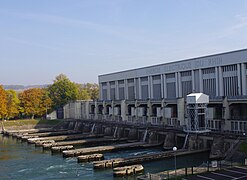
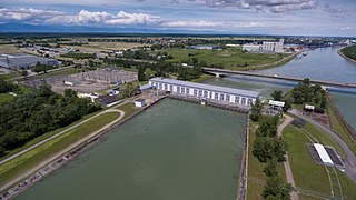
In the course of the canal there are four barrages with hydropower plants , which all belong to the French energy company Électricité de France (EDF):
- Kembs power plant , completion 1932, new concession 2011
- Ottmarsheim power plant , completed in 1952
- Fessenheim power plant , completed in 1956
- Vogelgrun power plant , completed in 1959
Location of the Fessenheim hydropower plant (reddish area above the nuclear power plant )
Vogelgrün barrage (near Breisach ) from the inside
Marckolsheim power plant (inflow via loop solution )
Locks
The four lock systems are designed as double locks. The Kembs lock has two lock chambers 25 m wide and 185 m long. The other three locks each have a chamber with 12 × 185 m and one with 23 × 185 m.
ecology
Groundwater level
The construction of the canal lowered the water table to such an extent that agricultural use of the floodplains was impossible on both the German and the French side ; For this reason, a " loop solution " with a total of four loops for improved navigation and energy generation was implemented between Breisach and Strasbourg instead of a continuous canal .
Flood
The construction of the ten barrages in the Upper Rhine accelerated the drainage of the Rhine, especially during floods. In the 19th century the Rhine was able to meander strongly in its floodplains. The weirs at the power plants serve to discharge floods, as well as to maintain the water level for the power plants to generate energy and the water level for shipping in the canal. The faster water drainage eliminates the risk of flooding in the canal section of the Rhine, but promotes the convergence of high water peaks of the Rhine with those of the tributaries Neckar , Main and Moselle and thus increases the risk of flooding on the Middle Rhine and Lower Rhine . In the event of flooding, maximum energy utilization is no longer possible due to the lower head at the barrages near the power plants: From a flow rate of approx. 3,300 m³ per second with an increasing tendency in Basel and when a discharge of 4,200 m³ / s is reached or exceeded at the Maxau gauge , the so-called special operation of the Rhine power plants is carried out. The Rhine power plants throttle the inflow to a minimum of 200 m³ / s and the remaining amount of water is directed through the weirs into the original Rhine bed (max. 4500 m³ / s). This special operation of the Rhine power plants was decided as part of the flood retention measures of the Integrated Rhine Program (IRP). The retention volume is approx. 45 million m³.
Minimum water flow in the old Rhine
In January 2011, the new concession of the Kembs hydropower plant, which had been controversial for many years between nature conservationists, France and Switzerland, came into force until 2035: a significant increase in the minimum water flow for the Old Rhine was agreed here.
Old Rhine channel, gravel debris, aquafauna
In a feasibility study on the redynamization of the rest of the Rhine (interreg project 2010–2012), the addition of approx. 25,000 m³ of gravel near Kleinkems examined whether the bed load dynamics of the Old Rhine could be improved as a result: this should improve the conditions for gravel-spawning fish species, among other things .
Loop solution
The shipping route between Strasbourg / Kehl and Breisach runs alternately in the old bed of the Rhine and in canal sections known as "loops". At each loop there is a barrage with a power station and two locks. In the sections of the Rhine next to the loops, a culture weir was built in Kehl, which, together with fixed thresholds, ensures that the water table does not fall any further. The drop in the groundwater level could only be reduced by the loop solution. The deep erosion of the river also remained a problem due to its shortening and the associated steeper gradient. In order to limit the ecological consequences of the loop solution, the continuous old retraction was created on the German side from the connection of existing old Rhine rivers.
The construction of further barrages (barrage Gambsheim (1974) and Iffezheim (1977)) served not only to generate energy but also to avoid further erosion of the river bed. Below Iffezheim , bed erosion is prevented or regulated by the water and shipping administration by regularly adding bed load. If this cannot be met, Germany and France would have to negotiate whether a further barrage will be built in the Lauterburg-Neuburgweier area. The costs would be around 1–2 billion euros.
Coordinates
- Starting point of the canal: 47 ° 36 ′ 59 ″ N , 7 ° 34 ′ 18 ″ E
- End point of the canal: 48 ° 2 ′ 0 ″ N , 7 ° 34 ′ 5 ″ E
Rhine kilometers: start, km 173.55 - end, km 226.25
Web links
- The rust gnaws: EdF renovates locks on the Upper Rhine Badische Zeitung from April 16, 2013
Individual evidence
- ↑ see disc
- ↑ Art. 358 of the Versailles Treaty at documentArchiv.de
- ↑ Annette Mahro: A building with a high stimulus factor . Badische Zeitung , March 9, 2009, accessed April 10, 2014
- ↑ badische-zeitung.de, Nachrichten, Südwest , January 18, 2011, Michael Baas: More water for the old Rhine (August 21, 2011)
- ↑ International database for buildings and civil engineers , structurae.de: hydroelectric power plant Ottmarsheim - photo and picture gallery
- ↑ badische-zeitung.de, Nachrichten, Südwest , January 18, 2011, Michael Baas: More water for the Old Rhine (August 14, 2011)
- ↑ badische-zeitung.de, Lokales, Saint-Louis , January 18, 2011, Michael Baas: Power plant has a new concession (August 14, 2011)
- ↑ badische-zeitung.de, Lokales, Efringen-Kirchen , October 26, 2010, or: gravel bank in the service of fish (August 14, 2011)


