
Schmida (river)
| Schmida | ||
 Schmida, near Hippersdorf |
||
| Data | ||
| location | Lower Austria | |
| River system | Danube | |
| Drain over | Krumpenwasser → Danube → Black Sea | |
| source | At Harmannsdorf 48 ° 36 ′ 2 ″ N , 15 ° 44 ′ 47 ″ E |
|
| Source height | approx. 370 m above sea level A. | |
| muzzle | At Korneuburg in the Danube Coordinates: 48 ° 20 ′ 29 " N , 16 ° 18 ′ 50" E 48 ° 20 ′ 29 " N , 16 ° 18 ′ 50" E |
|
| Mouth height | approx. 175 m above sea level A. | |
| Height difference | approx. 195 m | |
| Bottom slope | approx. 2.6 ‰ | |
| length | 73.6 km | |
| Catchment area | 484.4 km² | |
| Left tributaries | Urtlbach (Kühnringbach), Gerstfeldgraben, Latinbach, Stoitzengraben, Maigner Bach, Stepentalbach, Grundfeldgraben, Goggendorfer Bach, Kühberggraben, Rohrbach, Therngrabenbach, Ameisthalergraben, Hirschberggraben, Hundsgraben | |
| Right tributaries | Florianibach, Kalvarienberggraben, Grafenberger Bach, Grundgraben, Straningbach (Regelsbach), Schleinitzbach, Dürnbach, Ravelsbach, Gartenbach, Baritz, Ruppersthaler Graben | |
| Communities | Eggenburg , Sitzendorf an der Schmida , Ziersdorf , Großweikersdorf , Heldenberg | |
The Schmida is a left tributary of the Danube in northern Lower Austria. It is the main river of the Schmidatal .
Surname
The name is derived from the Old High German word * smid (= blacksmith) and alludes to the fact that the river had the necessary water power to drive hammer forges. It was first mentioned as "Smidaha" in 864. A frequently used variant of the name is "Schmidabach" (formerly also "Schmiedabach"), a term that is still in use today, especially in everyday language. On the maps of the Josephinische Landesaufnahme (1763–1787) the river is roughly named "Schmiedabach". The Schmida is also referred to as "Kleine Schmida" in the upper reaches - the term (or even a river) "Große Schmida" does not exist.
geography
source
.jpg)
The headwaters of the Schmida are located in the municipality of Burgschleinitz-Kühnring east of the village of Harmannsdorf in the arable land immediately north of the federal highway 4 . Originally several sources fed the Schmida, as can be seen on the maps of the Josephinische Landesaufnahme (1763–1787) . And the following description of the headwaters comes from 1835:
-
The Schmiedabach has its sources on the southern furrow which the Manhardsberg forms with the branch, which separates from it northeast of Horn [..]
Nowadays these springs do not exist anymore, the springs are contained and the water is led in underground pipes to an artificially created collecting basin, which now forms the origin of the Schmida as a spring pond .
course
.jpg)
The Schmida first flows in a north-easterly direction via Kühnring, where there is also a waterfall about 4 m high, to Eggenburg (in this section it is also known as "Kleine Schmida" on bridges), finally flows through Eggenburg and bends about 10 km further east near Roseldorf towards the south, from where the valley is also called Schmidatal . From here the Schmida flows canalised. The important places in the Schmida Valley such as Sitzendorf an der Schmida , Frauendorf, Ziersdorf and Großweikersdorf are then flowed through and at Hippersdorf the Schmida enters the northern Tullnerfeld through the Wagram , where it flows in a south-easterly direction to the mouth towards the Danube.
Estuary

The Schmida no longer flows directly into the Danube, but into a former branch of the Danube, the "Stockerauer Arm" located in the Stockerauer Au, into which the Göllersbach also flows after approx. 2.5 km . After about 1 km, the Stockerauer Arm becomes "Krumpenwasser", which flows parallel to the Danube as far as Korneuburg and flows into the Danube a few meters in front of the shipyard .
The Schmida - after crossing the Stockerauer Schnellstraße (near Tulln) -, the Stockerauer Arm and the Krumpenwasser are located in the European protected area “Tullnerfelder Donauauen” (see: List of European protected areas in Lower Austria ).
Tributaries
From the source to the mouth. Selection.
- Urtlbach , also Kühnringbach , from the left at Kühnring (Markt Burgschleinitz-Kühnring )
- Latinbach , from the left in front of Stoitzendorf (municipality of Eggenburg )
- Grafenberger Bach , from right to Klein-Reinprechtsdorf (Markt Röschitz )
- Maigner Bach , from the left in front of Roseldorf ( Sitzendorf an der Schmida market )
- Grundgraben , from right to Goggendorf (Sitzendorf an der Schmida market)
- Straningbach , from the right in Sitzendorf an der Schmida
- Schleinzbach , from the right opposite the Tabormühle von Frauendorf an der Schmida (Sitzendorf an der Schmida market)
- Dürnbach , from right to Frauendorf an der Schmida
- Ravelsbach , from the right opposite Hollenstein (Ziersdorf market)
- Gartenbach , from the right through Ziersdorf
- Baritz , from the right across from Dippersdorf (Markt Ziersdorf)
- Rohrbach , from the left opposite Glaubendorf (municipality of Heldenberg )
- Hundsgraben , from the left opposite the Großwiesendorf-Tiefenthal stop (Markt Großweikersdorf )
- (Branch of the Schmiedamühlbach ), to the left at Absberg (Markt Absdorf )
- Stranzendorfer Bach , from the left near Schmida (municipality of Hausleiten )
Flora and fauna
.JPG)
In the Schmida feeder streams in the Waldviertel there are still isolated crayfish , and there is hope that otters will settle in the Schmida estuary . In recent years, beavers have also spread along the Schmida due to a resettlement project .
However, the low water quality and the stream bed, which is monotonously regulated over long stretches, make the Schmida an unsuitable habitat for rare animal and plant species in large parts of its course. Hardly anything has been left of the originally existing extensive wetlands since the 19th century. Recently, however, there have been increasing efforts to dismantle the Schmida and to combine the construction of retention basins with the creation of wetlands (as already happened in Roseldorf ). These measures not only serve environmental protection, but also create new local recreation areas for the population along the Schmida.
As part of measures to improve the Vorflutfunktion Schmida was found at the mouth of a total of 23 fish species, and also protected species such as the standing Loach and loach occurred.
See also: Waters in the Weinviertel
Water quality
The pollution from municipal wastewater could be reduced by the construction of sewage treatment plants, which has led to an improvement in the water quality; the condition of the Schmida (quality class II - III) can still be described as bad. Only 3% of the Austrian water network is assigned to even lower quality classes. The Schmida has a high level of nutrient and suspended matter pollution, as the catchment area consists largely of arable farming and the drainage productivity of the catchment area is low. This not only has a negative effect on their habitat function, but also leads to considerable pollution of the Danube meadows in the mouth of the Schmida ( Tullnerfelder Donauauen ). The consortium Natura 2000 Weinviertel has pointed out that the plant could defuse the situation of buffer zones in the form of non-tilled strips along the creek. - Another problem is the contamination of the groundwater in the northern Schmida area with the forbidden pesticide atrazine , which is transported through the Schmida to the Tullnerfeld Donauauen.
Floods and regulation
.JPG)
The Schmida was feared from time immemorial for the recurring floods. In the topographic tables from 1817 (Niederösterreichisches Landesarchiv) it says:
-
By the village [= Königsbrunn am Wagram ] runs the dangerous Schmiedabach, which causes great damage here due to frequent floods.
In a session of the Lower Austrian Parliament (1953) it is noted in the minutes:
-
We also know that the Schmieda and the Krems always cause the greatest damage in disasters. [..] The "Kleine Volksblatt" wrote that at least 300 hectares of arable land were inundated by the Schmida floods [..] The Schmida is only partially regulated. 32 kilometers are not regulated at all [..]
A regulation of the Schmida was therefore carried out to protect against flooding. It took place in stages, for example in 1906 the Schmida was regulated between Roseldorf and Braunsdorf, in 1921 the Schmida was regulated from Sitzendorf to the mill in Frauendorf, and from 1951 to 1957 the Schmida in Absdorf was regulated by an annex of a new stream bed . The regulation was carried out by river straightening and the construction of a dam , the Schmid dam . To enrich the water with oxygen, cascades were built into the new course of the river.

On an area of around 12 hectares , the municipality of Sitzendorf an der Schmida in the local area of Roseldorf built a retention basin with a storage volume of around 250,000 cubic meters, which was completed in 2004. It is designed in such a way that the Schmida meanders through the pool in a natural course and already fills the many small ponds when it rains a little . This biotope thus forms a natural habitat for birds, frogs and game and at the same time brings about an improvement in the low water balance of the Schmida, which is of particular importance for the local flora and fauna .
In 2010, after unusually heavy rainfall, the water level of the Schmida almost reached the dam height.
Amount of water
Measuring station: There is a measuring station near Hollenstein (municipality of Ziersdorf) . In the long-term average, the flow rate here is between 0.15 and 0.45 m³ / s, depending on the season, with the months February, March and April having the highest and the months September and October the lowest average flow rates. Only in four events since 1951 has the flow rate exceeded 4 m³ / s.
Mouth: The discharge size at the mouth averages 1.0 m³ / s; Compared to the size of the catchment area, this results in a discharge of around 2 liters per second and square kilometer of catchment area.
economy
In earlier times there were countless water mills on the Schmida . Local researcher Otto J. Schöffl was able to prove 80 mills along the Schmida between Eggenburg and the confluence with the Danube (at that time near Tulln). A mill near Absberg was first mentioned in a document in 1258 in connection with the Absberg monastery. This mill and a few others still exist today, even if in our time the water power of the Schmida is no longer used as drive energy.
The flow rates as well as the achievable heads are so low that the Schmida hardly seems to be able to use water power in a profitable manner. A potential study from 2010 showed a possible standard energy capacity of 273 MWh / a, which would be enough to supply 62 households with an assumed average household consumption of 4,400 kWh / a. The Schmida is also often frozen over in cold winters and occasionally almost dried out in late summer.
literature
- Mühlen im Wandel, Using the example of Schmidatal in the Weinviertel - Volume 1, by Otto J. Schöff, Verlag Ferdinand Berger & Sons GesmbH., Horn
- The Schmida: Introducing a Region, by Friedrich Damköhler (Author), Josef Stefan (Illustrator), 2010, ISBN 978-3-200-02028-3
Picture gallery

Schmida, outflow from the spring pond

The Schmida near Absdorf (in autumn)

The Schmida near Absdorf (in winter)

Schmida - water cascades
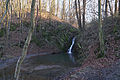
Schmidawasserfall near Kühnring
.jpg)


.jpg)
Individual evidence
- ↑ BMLFUW (Hrsg.): Area directory of the river areas: Danube area from the Enns to the Leitha. In: Contributions to Austria's Hydrography Issue 62, Vienna 2014, p. 105. PDF download , accessed on July 8, 2018.
- ↑ E. Schuster: The Etymology of Lower Austrian Place Names , Part 3, Association for Regional Studies of Lower Austria, 1994 Vienna, p. 525ff
- ↑ ... area at the SMIDAHA , in the history of Absdorf on www.absdorf2011.at
- ^ The Schmida in "Representation of the Archduchy of Austria under the Ens, Volume 6, 1835"
- ^ Name Schmiedabach , Josephinische Landesaufnahme (1763–1787)
- ^ Headwaters of the Schmiedabach, Josephinische Landesaufnahme (1763–1787)
- ^ Sources of the Schmiedabach in a book from 1835, on books.google.at
- ^ Report on the evacuation of Schmida and Stockerauer Arm
- ^ Schmiedabach floods, local history research region Kirchberg am Wagram
- ↑ Stenographic minutes of the Lower Austrian Parliament, Wednesday, August 12, 1953 (PDF)
- ↑ Schmidaregulierung in "History of Braunsdorf"
- ↑ Schmidaregulierung in "Geschichte von Frauendorf" ( Memento of the original of December 27, 2015 in the Internet Archive ) Info: The archive link was inserted automatically and not yet checked. Please check the original and archive link according to the instructions and then remove this notice.
- ↑ Schmida regulation in "Historical Development of Absdorf"
- ^ Schmida Hochwasser, August 2010, near Stetteldorf
- ↑ YouTube video: Schmida Hochwasser, August 2010, Grosswetzdorf
- ↑ from "Mühlen im Wandel" by Otto J. Schöffl
- ^ From "The industrial legacy of Lower Austria: history, technology, architecture", page 57
- ↑ Analysis of the energetic current state of the Weinviertel Manhartsberg region , 2010, page 62f, (PDF) ( Memento of the original from December 27, 2015 in the Internet Archive ) Info: The archive link was automatically inserted and not yet checked. Please check the original and archive link according to the instructions and then remove this notice.