Semenic Mountains
| Semenic Mountains | |
|---|---|
|
The Banat Mountains with the Semenic Mountains |
|
|
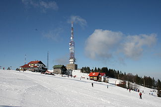
The Semenic ski area |
|
| Highest peak | Piatra Goznei ( 1447 m ) |
| location | Romania |
| Part of the Western Romanian Carpathians | Carpathians |
| Coordinates | 45 ° 5 ' N , 22 ° 3' E |
The Semenic Mountains ( Romanian Munții Semenicului , Hungarian Szemenik-hegység ) is a low mountain range in the south of the Banat . The Semenic Mountains are located in the south-west of Romania and are part of the Banat Mountains . It reaches peaks of up to 1450 meters and forms the southern section of the Western Romanian Carpathians . The mountain range owes its name to an endemic white-pink blooming flower, which has its flowering time in the months of July-August and is widespread on the meadows of the Semenics. In 2000, the Semenic-Cheile Carașului National Park was designated a nature reserve.
Location and directions
The Semenic Mountains are 35 kilometers from Reșița . It dominates the area with an altitude of over 1400 meters and is nicknamed the “Roof of the Banat”, although it is not the highest mountain range in this part of the country. At 1,447 meters, the Piatra Goznei is the highest peak in the Semenic Mountains.
Two access roads allow you to arrive via Reșița or Caransebeș :
- Reșița - Cuptoare - Văliug - Prislop - Semenic
- Caransebeş - Slatina-Timiş - Brebu Nou - Trei Ape - Prislop - Semenic
The distance is about the same on both access roads. In winter, the route via Reșița is usually preferred. The last part of the access road Prislop-Semenic overcomes a difference in altitude of 400 meters over a distance of 8 kilometers.
description
Its three peaks Semenic (1445 meters), Piatra Goznei (1447 meters) and Nedeia (1439 meters) form a triangle. You can see the other two from each peak. Between the Gozna and the Nedeiaspitze there is a small, natural lake Baia Vulturilor ( German Eagle Bath ), which is said to have special healing powers. The plateau in between mimics the high mountain pastures with large meadows . The mixed forest with spruce , fir and beech begins at the edge of the plateau .
Here are also the sources of the rivers that have their source in the Semenic Mountains, Bârzava , Nera and Timiș . The Timiș actually arises from three tributaries, the streams Molid , Semenic and Brebu . At Brebu Nou there is the reservoir of the same name . The waters that arise in the Semenic Mountains were partially connected by a hydrographic network as early as the 19th century . The dam was built exactly where the three bodies of water flow into one another:
- In 1909 the reservoir "Breazova" was built next to Văliug, one of the first reservoirs in Romania.
- In 1947 the construction of the Gozna reservoir began.
- A few years later the "Trei Ape" reservoir was created.
tourism
Until the First World War there was practically no organized tourism on the Semenic. On the vast plateau, which extends over an area of 4,000 hectares, the shepherds wandered through with their flocks or the farmers came to the haymaking. In 1911, the Friends of Nature founded the first tourist association in the Banat, which was oriented more towards the Danube-narrow Iron Gate , Ada Kaleh and the much more imposing Retezat Mountains . It was not until 1920 that the first Semenic hikes were initiated by the Catholic priest Paul Fulda and the math teacher Bruno Windhager . Together with the landlord Jakob Weinfurter , they brought skiing to life on the Semenic. In 1925 the German teacher Alexander Tietz founded the Wandervogel association , which carried out the first organized hikes in the Banat. The first wooden refuge was built in 1930 and the first stone mountain hut in 1933 . Thus the foundation stone of the tourist facility was laid. On the way to the Semenic plateau, you pass through the tourist places Văliug, Gărâna , Brebu Nou and Crivaia .
The Semenic Mountains, although not high, are characterized by a special abundance of snow . Statistically, there is a compact snow cover here 6.5 months per year and its thickness is over one meter for 3–4 months, even in winters with little snow. In winter, the Semenic is the number one ski area in the Banat. The climate is mild and well tolerated. In winter the temperatures are between −5 ° C and −20 ° C, in summer between 10 ° C and 25 ° C. Thanks to the abundance of snow, the agreeable climate, the easy access, the hiking and excursion possibilities, the Semenic Mountains are a popular holiday and excursion destination. There are various accommodation options in cabins, hotels and villas .
Web links
- dfbb.ro (Semenic Mountains and Gozna Lake)
- turismromania.ro (Semenic Mountains)
- Kulturraum-banat.de (Semenic-Plateau)
- banatulmontan.wordpress.com (Munții Semenicului, Romanian )
- cjcs.ro (skiing and mountain tourism)
Individual evidence
- ↑ istoriabanatului.wordpress.com , Mircea Rusnac: The beginnings of tourism on the Semenic (Începutul activităţii turistice pe Semenic)


