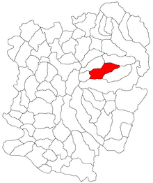
Slatina-Timiș
|
Slatina-Timiș Temesch-Slatina Temesszlatina |
||||
|
||||
| Basic data | ||||
|---|---|---|---|---|
| State : |
|
|||
| Historical region : | Banat | |||
| Circle : | Caraș-Severin | |||
| Coordinates : | 45 ° 16 ' N , 22 ° 17' E | |||
| Time zone : | EET ( UTC +2) | |||
| Area : | 151.09 km² | |||
| Residents : | 3,250 (2014) | |||
| Population density : | 22 inhabitants per km² | |||
| Postal code : | 327360 | |||
| Telephone code : | (+40) 02 55 | |||
| License plate : | CS | |||
| Structure and administration (as of 2016) | ||||
| Community type : | local community | |||
| Structure : | Slatina-Timiș, Ilova , Sadova Nouă , Sadova Veche | |||
| Mayor : | Roma Gheorghe ( PNL ) | |||
| Postal address : | Str. Principală, no. 32 loc. Slatina Timiș, jud. Caraș-Severin, RO- 327360 |
|||
| Website : | ||||
Slatina-Timiș (German: Temesch-Slatina , Hungarian: Temesszlatina ) is a municipality in the Caraș-Severin District , Banat , Romania . The Slatina-Timiș municipality also includes the villages of Ilova , Sadova Nouă and Sadova Veche .
Geographical location
Slatina-Timiș is located in the Caraș-Severin district, on the DN6 Timișoara - Orșova national road , 60 km from Reșița , 20 km from Caransebeș , 60 km from Băile Herculane , 30 km from Semenic , 20 km from Trei Ape and 42 km from Muntele Mic .
Neighboring places
| Lindenfeld | Vălișoara | Ilova |
| Weidenthal |

|
Sadova Noua |
| Wolfsberg | Sadova Veche | Sat Bătrân |
history
Over the centuries, the place appeared under different spellings: 1433 Szlatina , 1500 Zlathyna , 1603 Also-Zlatina , 1808 Szlatina and Slatina , 1888 Temes-Szlatina , 1913 Temesszlatina .
On the Josephine land survey of 1717, the place Slatina on the Temes river is registered. After the Peace of Passarowitz (1718) the village was part of the Habsburg crown domain Temescher Banat .
The Roman Catholic Church in Slatina was built in 1739. The construction goes back to a vow that Franz von Lothringen , the husband of Maria Theresa , had taken because of a salvation from grave danger. The church was then taken over by the wife of Emperor Charles VI. , Empress Elisabeth , initially built for the patronage of the Blessed Virgin Mary , later the church was consecrated to St. Michael the Archangel .
As a result of the Austro-Hungarian Compromise (1867), the Banat was annexed to the Kingdom of Hungary within the dual monarchy of Austria-Hungary . The official place name was Temesszlatina .
The Treaty of Trianon on June 4, 1920 resulted in the Banat being divided into three , which resulted in Slatina Timiş falling to the Kingdom of Romania .
Population development
| census | Ethnicity | |||||||
|---|---|---|---|---|---|---|---|---|
| year | Residents | Romanians | Hungary | German | Other | |||
| 1880 | 3704 | 3186 | 30th | 468 | 20th | |||
| 1910 | 4582 | 3708 | 86 | 775 | 13 | |||
| 1930 | 4322 | 3469 | 10 | 677 | 166 | |||
| 1977 | 4208 | 3649 | 4th | 546 | 9 | |||
| 2002 | 3659 | 3468 | 1 | 189 | 1 | |||
Web links
- slatina-timis.ro , Slatina Timiș
- ghidulprimariilor.ro , Slatina Timiș Citizens Registration Office
- 7-zile.com , History of the Roman Catholic Church in Slatina Timiș
Individual evidence
- ↑ Mayoral elections 2016 in Romania ( MS Excel ; 256 kB)
- ↑ fatornyosfalunk.com ( Memento from July 10, 2011 in the Internet Archive ), Transylvanian place names
- ↑ uni-heidelberg.de , Swantje Volkmann: The architecture of the 18th century in the Temescher Banat
- ↑ kia.hu (PDF; 858 kB), E. Varga: Statistics of the number of inhabitants by ethnicity in the Caraș-Severin district according to censuses from 1880 - 2002


