Vrani
|
Vrani Wrany Alsóvarány |
||||
|
||||
| Basic data | ||||
|---|---|---|---|---|
| State : |
|
|||
| Historical region : | Banat | |||
| Circle : | Caraș-Severin | |||
| Coordinates : | 45 ° 2 ' N , 21 ° 29' E | |||
| Time zone : | EET ( UTC +2) | |||
| Area : | 35.92 km² | |||
| Residents : | 1,178 (2014) | |||
| Population density : | 33 inhabitants per km² | |||
| Postal code : | 327430 | |||
| Telephone code : | (+40) 02 55 | |||
| License plate : | CS | |||
| Structure and administration (as of 2016) | ||||
| Community type : | local community | |||
| Structure : | Vrani, Ciortea and Iertof | |||
| Mayor : | Moată Gheorghe ( PSD ) | |||
| Postal address : | Str. Principală, no. 93A loc. Vrani, jud. Caraș-Severin, RO-327430 |
|||
| Website : | ||||
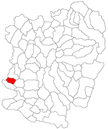
Vrani (German: Wrany , Hungarian: Alsóvarány ) is a municipality in the Caraş-Severin district , in the Banat region , in southwest Romania . The villages Ciortea and Iertof also belong to the municipality of Vrani .
Geographical location
Vrani is located in the extreme southwest of the Caraș-Severin district, on the border with Serbia . The village is located on the DJ573A Greoni - Iam county road , 20 km from Oravița .
Neighboring places
| Sočica / Serbia | Markovac / Serbia | Vărădia |
| Ciortea |

|
Broșteni |
| Berliște | Iertof | Răcășdia |
history
The first documentary mention dates back to 1402, when Mihai de Vrani was governor of the Sebesch fortress .
In the course of the centuries, different place names appeared: 1476 Waran , 1402 Wran , 1464 Wrani , 1699 Vranya , 1808 Vrany , 1851 Vrány , 1888 Vrány , 1910 Alsóvarány , 1920 Vraniu .
The historian Frigyes Pesty describes in his "History of the Severin Banat" that the place was registered in the "Nota Marsigliana" under the name Franyova , in the years 1690-1700 Vranya and 1723 Vranyova .
Wrann is entered on the Josephine land survey of 1717 . After the Peace of Passarowitz (1718) the village was part of the Habsburg crown domain Temescher Banat .
The Treaty of Trianon on June 4, 1920 resulted in the Banat being divided into three parts , whereby Vrani fell to the Kingdom of Romania .
Population development
| census | Ethnicity | |||||||
|---|---|---|---|---|---|---|---|---|
| year | Residents | Romanians | Hungary | German | Other | |||
| 1880 | 1618 | 1578 | 27 | 6th | 7th | |||
| 1910 | 1547 | 1499 | 8th | 12 | 28 | |||
| 1930 | 1310 | 1256 | - | 10 | 44 | |||
| 1977 | 641 | 531 | - | - | 110 | |||
| 2002 | 443 | 295 | 2 | 1 | 145 | |||
Web links
- ghidulprimariilor.ro , Vrani
- primaria-vrani.ro , Vrani
Individual evidence
- ↑ Mayoral elections 2016 in Romania ( MS Excel ; 256 kB)
- ↑ fatornyosfalunk.com ( Memento from July 10, 2011 in the Internet Archive ), Transylvanian place names
- ↑ primaria-vrani.ro , Vrani
- ↑ kia.hu (PDF; 858 kB), E. Varga: Statistics of the number of inhabitants by ethnicity in the Caraș-Severin district according to censuses from 1880 - 2002


