
Smolajny
| Smolajny | |||
|---|---|---|---|

|
|
||
| Basic data | |||
| State : | Poland | ||
| Voivodeship : | Warmia-Masuria | ||
| Powiat : | Olsztyn | ||
| Gmina : | Dobre Miasto | ||
| Geographic location : | 54 ° 2 ' N , 20 ° 24' E | ||
| Residents : | 520 (March 31, 2011) | ||
| Telephone code : | (+48) 89 | ||
| License plate : | NOL | ||
| Economy and Transport | |||
| Street : | DK51 Dobre Miasto - Lidzbark Warmiński | ||
| Next international airport : | Danzig | ||

Smolajny ( German Schmolainen ) is a village in the municipality Dobre Miasto ( Guttstadt ) in Olsztyn County ( Olsztyn district ) in the Polish province Warmia-Mazury .
Geographical location
The village is located in historic East Prussia , on the Alley , about five kilometers north of Guttstadt ( Dobre Miasto ), 18 kilometers southwest of Heilsberg ( Lidzbark Warmiński ) and 28 kilometers north of Allenstein ( Olsztyn ).
history

The village was founded in 1290 by Bishop Heinrich I. Fleming and in the 15th century it came into the possession of the Bishops of Warmia , who spent their summer holidays there. In the wars of 1414 , 1454 , 1519–1521 and 1709 it was destroyed and rebuilt again and again. The current building was built between 1741 and 1746 under Bishop Adam Stanislaus Grabowski .
In 1945 Schmolainen belonged to the district of Heilsberg in the administrative district of Königsberg in the province of East Prussia in Prussia .
Towards the end of the Second World War , the region was occupied by the Red Army in early 1945 . In the summer of 1945 Schmolainen was placed under Polish administration by the Soviet occupying power in accordance with the Potsdam Agreement, along with the southern half of East Prussia .
Population development
| year | Residents | Remarks |
|---|---|---|
| 1816 | 276 | |
| 1852 | 587 | 397 of them in the village and 190 on the farm |
| 1858 | 636 | 440 of them in the village (69 Protestants and 371 Catholics), 184 on the outskirts (46 Protestants and 138 Catholics) and twelve in the castle (one Protestant and eleven Catholics) |
| 1871 | 640 | |
| 1910 | 475 | 365 of them in the village, 97 on the Vorwerk and 13 in the castle. |
| 1933 | 430 | |
| 1939 | 716 | |
| 2011 | 520 |
Episcopal summer residence
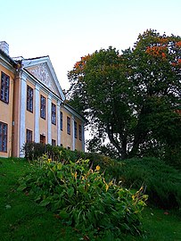
In the village is the summer palace of the Bishops of Warmia, which was built between 1741 and 1746 under Bishop Adam Stanislaus Grabowski and which became a popular place of residence for his successors. Ignacy Krasicki , Bishop of Warmia and Primate of Poland, had the gate tower built in 1765 and a landscape park laid out after 1782.
The castle is a two-story, single-wing building with central risers on the front and garden side. It is crowned by a hipped roof. The risalites have triangular gables with a cartouche of the builder's coat of arms . Inside, barrel vaults have been preserved on the ground floor and stucco ceilings in some rooms on the upper floor . After the Second World War , the palace complex was used by a state estate. During this time, the arrangement of the rooms was changed through renovations and the historical building fabric was badly affected. Since the early 1970s, the castle has housed an agricultural school.
On a hill to the northwest there is a hunting lodge from the end of the 18th century.
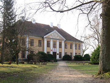
Summer residence of the bishops of Warmia
Tympanum with episcopal heraldic cartouche


Web links
- GenWiki: Schmolainen
- Life and fate of an East Prussian peasant family ( Memento from December 31, 2006 in the Internet Archive ) Contemporary witness report by Josef Block, 2002 (Schmolainen in 1945/47)
Footnotes
- ↑ a b GUS 2011: Ludność w miejscowościach statystycznych według ekonomicznych grup wieku (Polish), March 31, 2011, accessed on January 2, 2018
- ↑ Alexander August Mützell and Leopold Krug : New topographical-statistical-geographical dictionary of the Prussian state . Volume 4, Halle / Saale 1823, p. 258, item 2291.
- ^ Kraatz: Topographical-statistical manual of the Prussian state . Berlin 1856, p. 552.
- ↑ Adolf Schlott: Topographical-statistical overview of the government district of Königsberg, based on official sources . Hartung, Königsberg 1861, p. 113, paragraphs 116–118.
- ^ Gustav Neumann: The German Empire in Geographical, Statistical and Topographical Relationship (2nd edition of the Geography of the Prussian State ), Volume 2, Berlin 1874, p. 19, item 14.
- ↑ Uli Schubert, municipality directory, Heilsberg district
- ↑ a b Michael Rademacher: German administrative history from the unification of the empire in 1871 to the reunification in 1990. heilsberg.html # ew33hlsbschmolai. (Online material for the dissertation, Osnabrück 2006).