
Dobre Miasto
| Dobre Miasto | |||
|---|---|---|---|

|
|
||
| Basic data | |||
| State : | Poland | ||
| Voivodeship : | Warmia-Masuria | ||
| Powiat : | Olsztyn | ||
| Geographic location : | 53 ° 59 ' N , 20 ° 24' E | ||
| Residents : | 10,208 (Jun. 30, 2019) |
||
| Postal code : | 11-040 | ||
| Telephone code : | (+48) 89 | ||
| License plate : | NOL | ||
| Economy and Transport | |||
| Street : | DK 51 : ( Russia -) Bezledy - Lidzbark Warmiński ↔ Olsztyn - Olsztynek | ||
| Ext. 507 : Braniewo - Orneta - Dobre Miasto | |||
| Ext. 530 : Ostróda - Dobre Miasto | |||
| Rail route : | PKP line 221: Braniewo ↔ Gutkowo (- Olsztyn ) | ||
| Next international airport : | Danzig | ||
| Kaliningrad | |||
| Gmina | |||
| Gminatype: | Urban and rural municipality | ||
| Gmina structure: | 24 towns | ||
| 22 school authorities | |||
| Surface: | 258.70 km² | ||
| Residents: | 15,850 (Jun. 30, 2019) |
||
| Population density : | 61 inhabitants / km² | ||
| Community number ( GUS ): | 2814033 | ||
| Administration (as of 2009) | |||
| Mayor : | Stanisław Trzaskowski | ||
| Address: | ul.Warszawska 14 11-040 Dobre Miasto |
||
| Website : | www.dobremiasto.com.pl | ||

Dobre Miasto [ ˈdɔbrɛ ˈmʲastɔ ] ( German Guttstadt ) is a town in the powiat Olsztyński (powiat Allenstein) of the Polish Warmian-Masurian Voivodeship . In 2008 it had 10,483 inhabitants (2008).
Geographical location
The city is located in the historical region of East Prussia , on the Łyna (Alley) , about 25 kilometers north of Olsztyn (Allenstein) . The Olsztyn Lake District extends south of the city as part of the Masurian Lake District .
history


1325 the place in the Gudicus landscape in the old Prussian district Glottowia (Glottau), a Untergau of Pogesanien , was first mentioned as Guthinstat . The city was built in 1326. Founded by the Bishop of Warmia , the regularly rectangular settlement area replaced an old Prussian refuge. The descendants of the settlers from Lower Silesia preserved their dialect, so that a Lower Silesian language island existed in Guttstadt until 1945. The name was derived from the Prussian "gudde" bushes. According to medieval custom, the name was literally Latinized to Bona Civitas , and was converted to Dobre Miasto in the 16th century by the Polish settlers who settled in the neighboring area around Allenstein after the equestrian war . In 1329 Guttstadt received the Kulmische town charter and in 1371 a town hall.
Between 1347 and 1811 Guttstadt was the seat of the collegiate monastery for the Most Holy Redeemer and all saints . The monastery chapter originally included twelve, in 1782 five canons .
Between the Peace of Thorner of 1466 and 1772, the city belonged to the part of Prussia that remained from the Teutonic Order , which was subject to the suzerainty of the Polish crown. With the first partition of Poland in 1772 Guttstadt came to Prussia, where it was from 1818 to 1945 in the county Heilsberg , Administrative district Königsberg , Province of Prussia . The town was a garrison site that in 1782 housed three infantry companies .
At the beginning of June 1807, during the Fourth Coalition War , Guttstadt was the headquarters of the allied Prussians and Russians during the fighting with Napoleonic troops on the Allee and around Heilsberg . On June 6, 1807, the Russians defeated the French here, but then had to retreat to Bartenstein . On June 9th, Napoleon Bonaparte stayed in the building of the collegiate monastery.
At the beginning of the 20th century, Guttstadt had a Protestant church, which was built in 1830–1834 by Karl Friedrich Schinkel at the instigation of Friedrich Wilhelm III. had been built, as well as two Catholic churches (including the cathedral), a synagogue (built in 1855), a district court and an iron foundry. The well-attended pilgrimage site Glottau was near Guttstadt . The synagogue was burned down on November 9, 1938 ; later the Jewish community was forced to sell the building to the NSDAP.
At the end of the Second World War , the city was partially destroyed in the spring of 1945. After the end of the war, Guttstadt was placed under Polish administration by the Soviet occupying power in accordance with the Potsdam Agreement, together with the southern half of East Prussia. The immigration of Polish civilians began. Guttstadt received its current Polish name Dobre Miasto .
Population development until 1945
| year | Residents | Remarks |
|---|---|---|
| 1782 | over 2,300 | |
| 1802 | 2,547 | |
| 1810 | 1,519 | |
| 1816 | 1,848 | including 67 Evangelicals, 1,729 Catholics and 52 Jews |
| 1821 | 2,395 | |
| 1831 | 3.141 | German |
| 1858 | 3,568 | including 329 Protestants, 3,070 Catholics and 169 Jews |
| 1871 | 4,241 | including 350 Protestants and 180 Jews |
| 1875 | 4,350 | |
| 1880 | 4,487 | |
| 1890 | 4,504 | 399 Protestants and 212 Jews |
| 1900 | 4,588 | mostly Catholics |
| 1910 | 5,039 | |
| 1933 | 5,421 | |
| 1939 | 5,976 |
traffic
State road 51 runs through the city to the border crossing to the Russian exclave of Kaliningrad Oblast, 90 kilometers away .
There is a rail connection on the Olsztyn– Braniewo line (Allenstein - Braunsberg).
local community
The town and country municipality of Dobre Miasto includes 22 districts (German names until 1945) with a Schulzenamt:
|
|
|
Other localities in the municipality are Kłódka (Klutkenmühle) and Wichrowo (Wichertshof Forest District ) .
Attractions
- The collegiate church and today's basilica of the Most Holy Savior and All Saints , a three-aisled Gothic hall church, was built from 1375 to 1389 together with the collegiate monastery .
- The St. Nicholas Church was built from 1736 to 1741 in the late Baroque style and was used by the Greek Orthodox community from 1957. Today she belongs to the Ukrainian Greek Catholic Church in Poland.
- The former Evangelical Church was consecrated in 1833. After the Second World War it was used as a restaurant and burned out in 1968. Once repaired, it serves as the city library.
- The stork tower with remains of the old city wall dates from the 14th century.
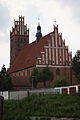
Collegiate Church

Kollegiatstift

Former Evangelical Church

Greek Catholic Church of St. Nicholas
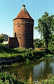
Stork tower


.jpg)
sons and daughters of the town
- Johann Niedermann (1759–1833), portrait and history painter in Vienna
- Waldemar Krossa (1836–1919), District Administrator in Ragnit
- Friedrich Ernst Dorn (1848–1916), German physicist
- Cölestin Krebs (1849–1922), manor owner and member of the German Reichstag
- Augustinus Bludau (1862–1930), Catholic bishop
- Max Meirowsky (1866–1949), German industrialist and art collector
- Emil Meirowsky (1876–1960), German dermatologist
- Emil Kronheim (1890–1971), German-Swedish rabbi
- Curt Johannes Braun (1903–1961), German writer and screenwriter
- Herbert Ossowski (1928–2010), German author for young people
- Johannes Tobei (1930–1997), German theologian
- Norbert Wojnarowski (* 1976), Polish politician
Twin cities
- Quakenbrück , Germany, since 2000
- Montierchaume , France, since 2002
literature
- Johann Friedrich Goldbeck : Complete topography of the Kingdom of Prussia . Part I: Topography of East Prussia . Königsberg / Leipzig 1785, p. 21, no. 5).
- August Eduard Preuss : Prussian country and folklore or description of Prussia. A manual for primary school teachers in the province of Prussia, as well as for all friends of the fatherland . Bornträger Brothers, Königsberg 1835, p. 509, no.101.
- News of the church buildings in Guttstadt in the years 1828 and 29, in particular of the laying of the foundation stone on June 10, 1829 in the dasigen neue evangel. Church . In: Preußische Provinzial-Blätter , Volume 3, Königsberg 1830, pp. 65–72 .
- Mikkels Klussis: German-Prussian basic dictionary for subsequent vocabulary recreation (Samland dialect) = Bāziskas prūsiskai-miksiskas wirdeīns per tālaisin laksikis rekreaciōnin = Prūsų-vokiečių-prūsų kalbų žodynas . Institut Européen des Minorités Ethniques Dispersées with the support of the German-Prussian association Tolkemita. Biznio Mašinų Kompanijos, Vilnius 1998/99, ISBN 9955-430-06-0 .
- Hans Georg Podehl: 4444 East Prussian names declared in Prussian . Rautenberg, Leer 1987, ISBN 3-7921-0356-7 .
- Victor Röhrich : The settlement of the Warmia with special consideration of the origin of the settlers . In: Magazine for the history and archeology of Warmia . 22, 1926, ISSN 0342-3344 , pp. 256-279 (reprinted in: Tolkemita-Texte 62, Dieburg 2002, pp. 275 f.).
- Erich Weise (Hrsg.): Handbook of historical places . Volume: East and West Prussia (= Kröner's pocket edition . Volume 317). Unchanged reprint of the 1st edition 1966. Kröner, Stuttgart 1981, ISBN 3-520-31701-X .
Web links
- City of Dobre Miasto (Polish, English)
Individual evidence
- ↑ a b population. Size and Structure by Territorial Division. As of June 30, 2019. Główny Urząd Statystyczny (GUS) (PDF files; 0.99 MiB), accessed December 24, 2019 .
- ^ A b c d Johann Friedrich Goldbeck : Complete topography of the Kingdom of Prussia . Part I: Topography of East Prussia . Königsberg / Leipzig 1785, p. 21, no. 5).
- ↑ a b c Meyer's Large Conversation Lexicon . 6th edition, Volume 8, Leipzig / Vienna 1907, p. 553.
- ↑ a b c d Alexander August Mützell, Leopold Krug : New topographical-statistical-geographical dictionary of the Prussian state . Volume 5: T-Z. Halle 1823, pp. 290–291, item 238.
- ^ August Eduard Preuss : Prussian country and folklore or description of Prussia. A manual for primary school teachers in the province of Prussia, as well as for all friends of the fatherland . Bornträger Brothers, Königsberg 1835, p. 509, no.101.
- ↑ Adolf Schlott: Topographical-statistical overview of the government district of Königsberg, based on official sources . Hartung, Königsberg 1861, p. 110, item 37.
- ^ Gustav Neumann: Geography of the Prussian State . 2nd edition, Volume 2, Berlin 1874, p. 19, item 14.
- ↑ a b c d e Michael Rademacher: German administrative history from the unification of the empire in 1871 to the reunification in 1990. heilsberg.html # ew33hlsbguttstat. (Online material for the dissertation, Osnabrück 2006).
- ↑ The Genealogical Place Directory
- ↑ Colligate pen
- ↑ Evangelical Church

Urban and rural communities: Barczewo (Wartenburg) | Biskupiec (Bishop's Castle) | Dobre Miasto (Guttstadt) | Jeziorany (Seeburg) | Olsztynek (Hohenstein)
Rural parishes : Dywity (Diwitten) | Gietrzwałd (Dietrichswalde) | Jonkowo (Jonkendorf) | Kolno (Groß Köllen) | Purda (Great Purden) | Stawiguda (stabigottes) | Świątki (Heiligenthal)