
Solar eclipse of June 21, 2039
| Solar eclipse of June 21, 2039 | |
|---|---|

|
|
| classification | |
| Type | Ring-shaped |
| area |
North America , Russia , Europe , Arctic , Western North Africa Annular: USA , Canada , Greenland , Norway , Sweden , Finland , Baltic States , Belarus , Russia |
| Saros cycle | 147 (24 of 80) |
| Gamma value | +0.8313 |
| Greatest eclipse | |
| Duration | 4 minutes 5 seconds |
| place | Ellef Ringnes Island |
| location | 78 ° 55 ′ N , 101 ° 47 ′ W |
| time | June 21, 2039 5:11:39 PM UT |
| size | 0.9454 |

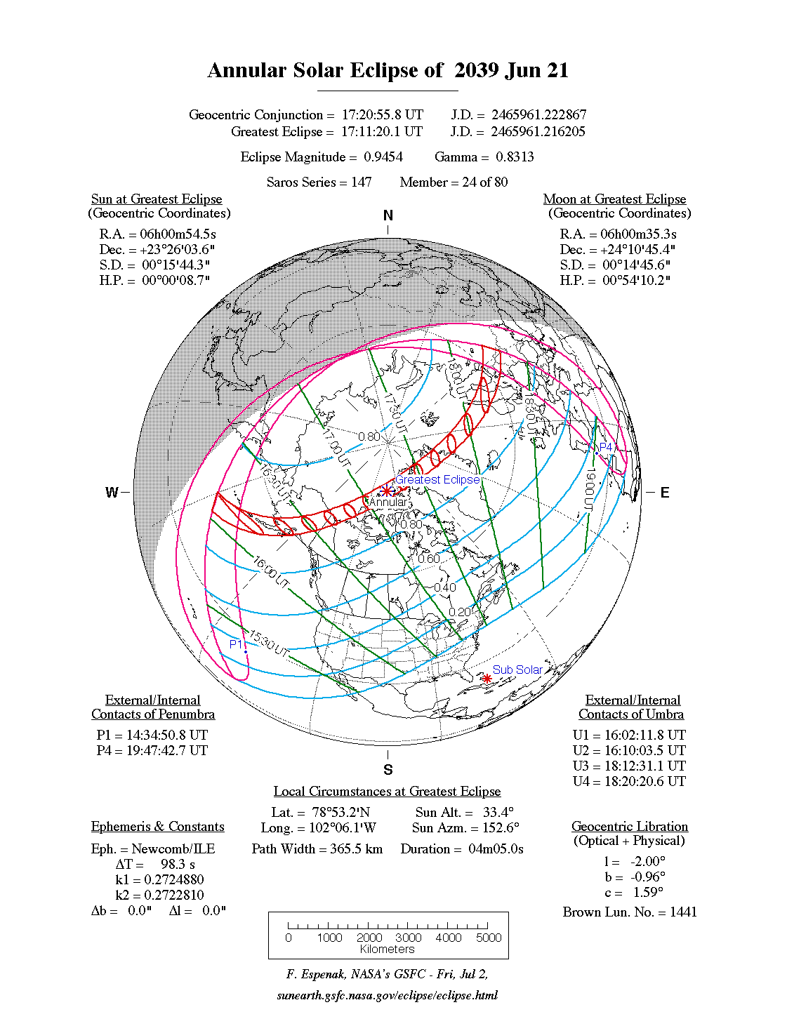
The annular solar eclipse of June 21, 2039 largely takes place over North America , Russia , Europe and western North Africa , as well as the Arctic and the North Atlantic . The maximum of the eclipse is on the uninhabited Canadian island of Ellef Ringnes Island ; the duration of the annular shape there is 4 minutes and 5 seconds. The eclipse belongs to the same Saros cycle to which the annular solar eclipse on July 23, 2093 , 54 years later , belongs, the central zone of which will lead over northern Germany.
course
The zone of the annularity begins at sunrise in the Pacific and moves in a north-westerly direction to the Aleutian Islands with the islands of Unalaska and Unimak as well as over the further US state of Alaska with the city of Anchorage . In the following, the Canadian territories Yukon and Nunavut are crossed. In the northern continuation of Baffin Bay , Smithsund , which is more frequently used by cruise ships in summer, the zone reaches its northernmost point and reaches Greenland . Without any further land contact, the North Atlantic is crossed and the coast of Norway reached near Mo i Rana . In Sweden , the cities of Umeå , Sundsvall and Gävle are within the annular zone, but Uppsala and Stockholm are outside. The south-west of Finland experiences the solar eclipse when the sun is low, as does all of Estonia , large parts of Latvia and north-east Lithuania . Belarus and Russia are reached at sunset .
Places in the ring-shaped zone
| country | place | Duration | Time ( UT ) | comment |
|---|---|---|---|---|
| United States | Anchorage | 3m 40s | 16:24 | |
| United States | Fairbanks | 3m 47s | 16:31 | |
| - | Smithsund | 4m 4s | 17:26 | |
| Norway | Bodø | 2m 41s | 18:05 | |
| Norway | Mo i Rana | 3m 31s | 18:07 | |
| Sweden | Umeå | 2m 48s | 18:10 | |
| Sweden | Ostersund | 3m 20s | 18:12 | |
| Sweden | Sundsvall | 3m 40s | 18:13 | |
| Sweden | Gävle | 2m 3s | 18:16 | |
| Finland | Vaasa | 2m 44s | 18:10 | |
| Finland | Tampere | 3m 01s | 18:12 | |
| Finland | Turku | 3m 45s | 18:14 | |
| Finland | Helsinki | 3m 25s | 18:13 | |
| Estonia | Tallinn | 3m 41s | 18:15 | |
| Latvia | Riga | 2m 24s | 18:18 | Darkness ends at sunset |
| Belarus | Vitebsk | 3m 35s | 18:17 | Darkness ends at sunset |
| Russia | Pskov | 3m 33s | 18:15 | Darkness ends at sunset |
| Russia | Smolensk | 3m 40s | 18:16 | Darkness ends at sunset |
Visibility in German-speaking countries
The eclipse is visible in German-speaking countries as a partial solar eclipse. In the south of Germany, as well as Switzerland and Austria , the sun sets partially eclipsed. The largest eclipse is achieved in the northeast, in Sassnitz on Rügen , with almost 80% coverage. The lowest eclipse is achieved in the southwest, in Zermatt in the Swiss canton of Valais , with a maximum of 60% coverage.
| country | place | cover | comment |
|---|---|---|---|
| Switzerland | Bern | 62% | |
| Switzerland | Basel | 63% | |
| Austria | Salzburg | 68% | |
| Austria | Vienna | 72% | |
| Germany | Munich | 67% | |
| Germany | Frankfurt am Main | 68% | |
| Germany | Berlin | 76% | |
| Germany | Hamburg | 75% |
Individual evidence
- ↑ a b c The duration of the ring shape and the time of the middle of the ring shape were determined with the interactive map of NASA ( Annular Solar Eclipse of 2039 Jun 21, Google Maps and Solar Eclipse Paths )
Web links
- NASA: Annular Solar Eclipse of 2039 June 21
- NASA: Google Maps and Solar Eclipse Paths: 2021-2040
- NASA: Solar Eclipses of Saros 147
|
Previous solar eclipses:
|
Later solar eclipses:
|
|||||||||
| January 16, 2037 (partial) |
13 July 2037 (total) |
January 5, 2038 (ring-shaped) |
July 2, 2038 (ring-shaped) |
December 26, 2038 (total) |
June 21, 2039 (circular) |
December 15, 2039 (total) |
May 11, 2040 (partial) |
November 4, 2040 (partial) |
April 30, 2041 (total) |
October 25, 2041 (ring-shaped) |
|
|
|
|
|
|
|
|
|
|
|
|
| Lists: 20th century • 21st century • All lists | ||||||||||