
Speyer alluvial forest
Coordinates: 49 ° 17 ′ 6 " N , 8 ° 28 ′ 23" E

The Speyer floodplain is on the district of the city of Speyer on the Rhine and Berghäuser Altrhein situated floodplain . It extends between the border district to the municipality Römerberg in the south along the Rhine main dike between this and the first Berghäuser Altrhein and after its confluence with the Rhine between Rhine Hauptdeich and Rhine to the new port of Speyer.
In the far north, Speyer still has a share in the Angelhofer Altrhein . The upper tree layer of the entire Speyer Rhine floodplain forest consisted of 29 percent ash , 26% poplar , 20% oak , 16% maple , 3% nut trees , 2% beech and 4% other tree species, especially willows .
The Speyer Auwald is partly owned by the city, partly owned by the State of Rhineland-Palatinate and along the Rhine owned by the Federal Republic of Germany , represented by the Mannheim Waterways and Shipping Office . Urban and state forest on the one hand and federal forest on the other hand are administered by two different forest offices.
Structure and characteristics of the alluvial forest
Rear Hammelweid and Sick'sche Wiese
Upstream in the Dammwachthaus area , which extends to the Römerberger district, there is the Hintere Hammelweid forest and the so-called Sick'sche Wiese , a river valley meadow with numerous rare species. The blue wasteland insect found on the edge of the Sick'schen Wiese is particularly rare . In a wet meadow at the dam guardhouse was Large copper butterfly demonstrated a protected species under Annex II of the Habitats Directive .
In the Hechenich, Runkedebunk, Horn Island
In contrast to the Berghäuser Altrhein, the Runkedebunk , which is no longer connected to the Rhine, separates the island of Horn from within the alluvial forest . The parcels to the east and west of the island of Horn and the narrow strip between Rheinhauptdeich and Runkedebunk are known as Im Hechenich .
Gold mine and louse pit
North of the main Rhine dike above the area Im Hechenich, Runkedebunk, Horn Island , there are the old waters of Goldgrube , so called because of the earlier extraction of Rheingold and extinguishing sand there, and the Lausgrube basin , which is often filled with pressurized water . (752 kB)
Birds
In the area Im Hechenich , Runkedebunk , Insel Horn and Goldgrube , occurrences of 15 strictly protected bird species and 11 particularly protected or endangered species were found, seven of which are listed in Annex I of the EU Birds Directive .
Strictly protected species
- Purple Heron (Runkedebunk), protection according to Annex I of the EU Birds Directive
- Black kite (1 eyrie in the gold mine), protection according to Annex I of the EU Birds Directive
- Habicht (Horn Island),
- Sparrowhawk (gold mine),
- Common buzzard (gold mine, Horn Island),
- Kestrel (gold mine),
- Tree falcon (gold mine),
- Wood sandpiper (gold mine),
- Kingfisher (gold mine, runkedebunk), protection according to Annex I of the EU Birds Directive
- Turning neck , (gold mine)
- Gray woodpecker , protection according to Annex I of the EU Birds Directive
- Green woodpecker , (northern gold mine)
- Black woodpecker , protection according to Annex I of the EU Birds Directive
- Medium woodpecker , protection according to Annex I of the EU Birds Directive
Specially protected species
- Little Grebe (gold mine),
- Great crested grebe ,
- Gray heron (gold mine, runkedebunk),
- Teal (gold mine),
- Water rail (gold mine),
- Little Woodpecker , (Horn Island)
- Yellow mockers (Horn island, gold mine),
- Oriole (Horn Island, gold mine),
- Red-backed killer , protection according to Annex I of the EU Birds Directive
- Bag tit (gold mine),
- Rook (gold mine),
- Laro Limikolen (50 species),
- Swimming birds (40 species)
On the island of Horn there were 81 trees with woodpecker holes, 45 of them in poplars , eleven in oaks , eight each in ash and willow , seven in birch , three in gray poplars and two in pear trees .
Bats
Detector images and nets were used to detect ten species of bats on Horn Island .
Strictly protected species
- Bechstein's bat , the expert found the reliable evidence of breeding occurrence particularly remarkable due to the capture of a pregnant female and the small radius of action of the species of 500 meters,
- Brown long-eared ,
- Great noctule bat ,
- Large mouse-eared mouse (uncertain detector evidence),
- Little Bearded Bat ,
- Little noctule bat ,
- Mosquito bat ,
- Rough-skin bat ,
- Water bat ,
- Pipistrelle .
Reptiles
The waters bonanza and Runkedebunk be of grass snakes , a Sonder protected and endangered species colonized the Rhine Hauptdeich at the height of the island of Horn and the Sick'sche meadow of sand lizards .
Amphibians
In the Runkedebunk, Goldgrube and Berghäuser Altrhein area, there are species records for the following species protected according to the Fauna-Flora-Habitat Directive:
- Combed newt , gold mine, relic inventory
- Common Garlic Toad
- Natterjack toad , gold mine, Sick'sche Wiese, pressurized water sinks
- Green toad , occurrence of several hundred, is a focus of the species
- Tree frog (northern border of the distribution area in the Rhine meadows)
- Moor frog , endangered species
- Little water frog , Runkedebunk, Berghäuser Altrhein
In the northern part of Hechenich, Rheinhausen ferry, Im Salmengrund
To the north, the parcel Im Unteren Hechenich is bounded by the road to the Rheinhausen ferry. In this area the Berghäuser Altrhein reaches the Rhine. The ferry docks at the end and during the Cold War a floating emergency bridge was stationed here in case of defense. Part of the site was designated and fenced off as a restricted military area. The parcel Im Salmengrund follows . The name is reminiscent of the former important salmon fishery in Speyer.
Schänzel, Ratswört, Rheinanlage, Herrenwiese
The Schänzel parcel follows north of the Salmengrund at the bend in the Rhine . Then follow the parcels Ratswört and Rhein-conditioning , of Speyerern the Anlach called. To the west of the dyke is the Herrenwiese , which used to be an excursion destination for city residents, where open-air concerts and dance events took place. Two more oxbow lakes extend to the east of the parcels.
At the Lußheimer Fahrt and Färchenwartel
The northern end of the Speyer alluvial forest is formed by the parcel An der Lußheimer Fahrt , the name of which is reminiscent of the ferry to Altlußheim , and finally the Färchenwartel, which tapers to a point . The western part of the An der Lußheimer Fahrt is a large river valley meadow . The pointed shape of the Färchenwartel results from the incision through the first of two harbor basins of the New Port of Speyer. The Braun shipyard and a yacht harbor are located there.
Valuable biotope types in the Speyer alluvial forest
- Reeds are found in particular in the gold mine , the Schluten within the island of Horn and in the Runkedebunk .
- Along the Berghäuser Altrhein on the island of Horn and on the northern edge of the island of Flotzgrün there is a narrow strip of softwood floodplain forest of the white willow floodplain forest .
- In the field of gold and Lausgrube grow White Willow societies.
- On the island of Horn there is a forest-dominated hardwood floodplain forest with ash and sycamore, but also natural complexes of the pedunculate oak-field elm floodplain forest (Querco-Ulmetum).
Protection status according to European law
EU bird sanctuary
The Speyer alluvial forest, sometimes referred to as South Auwald in Speyer , is part of the EU bird sanctuary DE 6716-402 "Berghäuser and Lingenfelder Altrhein" (excluding Goldgrund and Lausgrund). The short description is: Partly dredged old Rhine, soft and hard wood meadows as well as a system of reed-covered ditches and meadows rich in sedges characterize the floodplain complex between Germersheim and Speyer.
The need for protection results from: Stocks of reed and tree-breeding target species in considerable sizes. Backwaters and large areas of mud, including for Laro Limikolen, ducks, geese and other swimming birds, indispensable resting and passage areas. The conservation goal according to the " 791-1-17 State Ordinance on Conservation Goals in the Natura 2000 Areas of July 18, 2005 " reads: Conservation or restoration of a structured floodplain landscape with a natural mosaic of shallow water zones, mud and gravel banks, reed beds, soft and hardwood floodplain forests.
As types of main deposits pursuant to Article 4 paragraphs 1 and 2 of the birds directive in the area DE 6716-402 are detected: Black Milan , Kingfisher , means Specht , Blaukehlchen , Purpurreiher , Buzzard , harrier , Grauspecht , Schwarzspecht , Neuntöter , Corncrakes , water rail , Wendehals , Schilfrohrsänger , Great Reed Warbler , Tasmanian Tit , Terns , Limikolen , Swimming birds ( diving ducks ), Gudgeons , Geese , Cormorants , Seagulls .
Fauna-flora habitat
The Speyer alluvial forest is part of the FFH area DE 6716-301 Rhine Low Germersheim-Speyer . The brief description is: Rhine floodplain landscape with extensive hardwood floodplain forests, oxbow lakes, clay pit waters and reed stands. The need for protection results from: Rheinaue biotope complex with nationally rare plant communities and animal species. Habitats for migratory fish. Particular importance as a migration and resting area for birds. Bat habitats. Riparian forests rich in old wood.
gallery

View of the old Rhine arm Runkedebunk , on the right the island of Horn

The Sick'sche Wiese in the Speyer floodplain forest, a river valley meadow

Deadwood: an important habitat
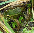
Frog in the gold background
Lausgrund and gold mine , on the horizon the Speyer Cathedral

Swan parade in the gold ground

Silting Schlute on the island of Horn

Softwood floodplain on the island of Horn , during light summer floods


.jpg)
.jpg)


Protection status, target planning according to state law and local law
Objective for the urban forest
On December 7, 1993, the City Council Speyer u. a. the following objectives for the urban forest were decided:
- State conservation measures and goals and other plans affecting the forest must be taken into account, in particular the landscape plan for the land use plan of the city of Speyer and the care and development plan for the Rhine lowland between Speyer and Germersheim, as well as the regulations on Natura 2000 areas (bird protection and FFH Directive). This also includes the future management plans for the Natura 2000 areas.
- In order to increase the diversity of biotopes, differences in the smallest localities should be taken into account in the choice of tree species.
- Increase in the proportion of overhangers, groups of old wood and dead wood; Refrain from using firewood in the forest areas to be defined in the respective forest management plans.
- Compliance with the certification guidelines.
For the Rheinauenwald it was also decided:
- Preservation and care of near-natural white willow stocks. Increase in their share in the softwood floodplains by converting suitable stocks or by new construction
- Cut back the pollarded willows every 5 years
- Initiate or continue the conversion of the black walnut and sycamore forest with natural species (species of natural forest communities typical of the area and location).
- Use cultivated poplar sparingly, reduce its share; fall back on old varieties that are genetically closer to the black poplars.
- In the Rheinauewald, the poplar is to be pulled out between the towpath and the old Rhine arm and a white willow riverine forest will be created.
Natural monuments
Since 1987 u. a. 55 approx. 100-year-old oaks in the Speyer alluvial forest have been designated by the city of Speyer as protected landscape components.
Gold mine as a protected part of the landscape
By ordinance of August 5, 1977, the gold mine area was placed under protection as a protected part of the landscape on the basis of Section 16 of the State Maintenance Act. The protection goal is the preservation of the water surface, the shore and the surrounding area because of its scenic character and to preserve the sites of rare plant communities.

Passenger ferry Rheinhausen ferry
In the alluvial forest is the landing stage for the Rheinhausen Ferry , a summer passenger ferry for hikers and cyclists that connects Speyer with Rheinhausen .
See also
- In the north of Speyer there is still the alluvial forest area: Angelhofer Altrhein
- As an example for the second type of forest in the Upper Rhine Rift : Speyer Forest
literature
Specialist literature
- Bernhard Glaß: The development of the bird populations in the landscape and nature reserve "Berghäuser Rheinaue" near Speyer between 1957 and 1983 . Bad Dürkheim 1985/86, communications from Pollichia 73, pages 265-288
- Bernhard Glaß: Corrections and additions to: "The development of the bird populations in the landscape and nature reserve 'Berghäuser Rheinaue' near Speyer in the years between 1957 and 1983. ", Landau 1990, Fauna, Flora Rheinland-Pfalz 5 (4), pages 785 -802
- Bernhard Glaß: The plant communities of the silting zone at the "Berghäuser Altrhein" near Speyer, Bad Dürkheim 1998, messages from Pollichia 73, pages 35-61
- Bernhard Glaß: Critical comments on the production of valuable wood in the Speyer Auenwald , Fauna, Flora Rheinland-Pfalz 10 (3), pages 1031-1077
- Bernhard Glaß: Changes in the water vegetation (Lemnetea and Potamogetonetea) in the area of the Berghäuser Altrhein near Speyer in the years between 1957 and 1989 . Fauna Flora Rhineland-Palatinate , Volume 6, Issue 4, Pages 981-1033, Landau
Official
- State ordinance for the landscape protection area Palatinate Rheinauen, in Law and Ordinance Gazette for the State of Rhineland-Palatinate No. 27, November 1983
- Carola Schnug-Bögerding: Landscape plan for the land use plan, June 2006, edited on behalf of the City of Speyer
Web links
Bird protection
- Bird Protection Directive (PDF; 131 kB)
- Map of the area
FFH
- Habitats Directive (PDF; 200 kB)
- FFH 6616-304 Rhine valley Speyer-Ludwigshafen
- Map of the FFH area in the map server
Individual evidence
- ↑ Medium-term operational planning (fortification plant) for the city and community hospital forest, submission 0006/2005 point 1 of the 3rd meeting of the environmental committee of the city of Speyer on February 17, 2005
- ↑ LAUB Gesellschaft für Landschaftanalyse und Umwelttechnik mbH: Extension of the runway at the Speyer airfield - landscape maintenance accompanying plan -, 2006, as application document V part of the documents for the plan approval procedure Extension of the runway at the Speyer airfield , page 42
- ↑ LAUB Gesellschaft für Landschaftanalyse und Umwelttechnik mbH: Extension of the runway at the Speyer airfield - landscape conservation plan -, 2006, as application document V part of the documents for the plan approval procedure Extension of the runway at the Speyer airfield , page 41
- ↑ Notgeld of the city of Speyer designed by Hanns Fay with gold panners on the Rhine on page 2 of the PDF file ( Memento from December 29, 2010 in the Internet Archive )
- ↑ LAUB Gesellschaft für Landschaftanalyse und Umwelttechnik mbH: Extension of the runway at the Speyer airfield - landscape conservation accompanying plan -, 2006, as application document V part of the documents for the plan approval procedure for the extension of the runway at the Speyer airfield , pages 35, 36, 37
- ↑ LAUB Gesellschaft für Landschaftanalyse und Umwelttechnik mbH: Extension of the runway at the Speyer airfield - landscape conservation plan -, 2006, as application document V part of the documents for the plan approval procedure Extension of the runway at the Speyer airfield , page 35
- ↑ LAUB Gesellschaft für Landschaftanalyse und Umwelttechnik mbH: Extension of the runway at the Speyer airfield - landscape conservation plan -, 2006, as application document V part of the documents for the plan approval procedure for the extension of the runway at the Speyer airfield , pages 38, 39, 40
- ↑ LAUB Gesellschaft für Landschaftanalyse und Umwelttechnik mbH: Extension of the runway at the Speyer airfield - landscape conservation plan -, 2006, as application document V part of the documents for the plan approval procedure Extension of the runway at the Speyer airfield , page 41
- ↑ LAUB Gesellschaft für Landschaftanalyse und Umwelttechnik mbH: Extension of the runway at the Speyer airfield - landscape maintenance accompanying plan -, 2006, as application document V part of the documents for the plan approval procedure Extension of the runway at the Speyer airfield , pages 40, 41
- ↑ More details on the old Rhine ferries in the article Rheinhausen Ferry
- ↑ The EU directives are also implemented in state law and their implementation is carried out by the state and city, but their design and implementation are ultimately determined by the previous EU law and there are also complaint procedures at EU level.
- ↑ http://www.natura2000.rlp.de/steckbriefe/sdb/VSG_SDB_6716-402.pdf
- ↑ http://rlp.juris.de/rlp/Natura2000GebV_RP_Anlage3.htm
- ↑ Carola Schnug-Böger thing: Landscape Plan for Land Use Plan, June 2006, working on behalf of the city of Speyer
- ↑ http://www.natura2000.rlp.de/steckbriefe/sdb/FFH_SDB_6716-301.pdf
- ↑ Land use plan 2020 , G Conceptual content - Explanation of the plan presentation 9.1, pages 223–225
- ↑ No. 60 of the list of protected landscape components and natural monuments in the urban area of Speyer
- ↑ § 3 of the ordinance on the protected landscape component gold mine of August 5, 1977 , 3.4 of the collection of local law of the city of Speyer.