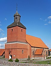
Stężyca
| Stężyca | ||
|---|---|---|

|
|
|
| Basic data | ||
| State : | Poland | |
| Voivodeship : | Pomerania | |
| Powiat : | Kartuski | |
| Gmina : | Stężyca | |
| Geographic location : | 54 ° 12 ' N , 17 ° 57' E | |
| Residents : | 2108 (March 31, 2011) | |
| Postal code : | 83-322 | |
| Telephone code : | (+48) 58 | |
| License plate : | GKA | |
| Economy and Transport | ||
| Rail route : | Kościerzyna – Gdynia | |
Stężyca ( German Stendsitz , formerly Stendzitz , Adlig Stendsitz ; Kashubian Stãżëca ) is a village in the powiat Kartuski of the Polish Pomeranian Voivodeship . It is the seat of the rural community of the same name .
Geographical location
The village is located in Kashubian Switzerland on the southern tip of Lake Radaune and on the northern shore of Lake Stendsitz in the former West Prussia , about nine kilometers north of the city of Kościerzyna ( Berent ), 21 kilometers southwest of Kartuzy ( Karthaus ) and 50 kilometers southwest of Danzig .
history
As tombs from the pagan period that were found in Stendsitz in the 19th century show, the region on the south bank of the Rdaune Lake was settled early on. In the first half of the 19th century, the place names Stendzitz and Stendzyc (pronounced:… schitz ) were in use for the place with a noble estate, a water mill on the Radaune and a Catholic parish church .
From 1308 to 1466 the village belonged to the Teutonic Order of Prussia ; a place name handed down from this time is Stansitz . In 1398 the pastor Johann and the church leaders at Stansitz settle a legal dispute.
After that, the place came with the division of Prussia into the western part, later also known as the autonomous Prussian Royal Part, which had voluntarily placed itself under the protection of the Polish crown. After the first Polish partition in 1772, the region became part of the Kingdom of Prussia . From 1818 to 1920 Sendsitz belonged to the Prussian district of Karthaus .
After the end of the First World War , most of the Karthaus district, including Adlig Stendsitz, had to be ceded to Poland due to the provisions of the Versailles Treaty in January 1920 for the purpose of establishing the Polish Corridor . As a result of the invasion of Poland in 1939, the Karthaus district with its residence was annexed by the German Reich in violation of international law and was assigned to the Gdansk administrative district in the Gdansk-West Prussia Reichsgau .
Towards the end of the Second World War , the district was occupied by the Red Army in the spring of 1945 . In the summer of 1945, the district with the village of Stendsitz was placed under the administration of the People's Republic of Poland by the Soviet occupying power in accordance with the Potsdam Agreement . In the following period, the German minority was expelled from Stendsitz by the local Polish administrative authority . The Protestant church stood empty in the post-war years.
Population development until 1945
| year | Residents | Remarks |
|---|---|---|
| 1816 | 22nd | |
| 1840 | 277 | in 38 houses |
| 1864 | 579 | on December 3rd |
| 1905 | 745 |
local community
The rural community of Stężyca includes 17 other places with a Schulzenamt ( sołectwo ) .
Web links
- Stendsitz district (Rolf Jehke, 2004)
- Catholic parish church Stendsitz (Uwe Kerntopf, 1998 ff.)
- Evangelical Church Stendsitz (Uwe Kerntopf, 1998 ff.)
Individual evidence
- ^ CIS 2011: Ludność w miejscowościach statystycznych według ekonomicznych grup wieku (Polish), March 31, 2011, accessed on June 28, 2017
- ^ E. Förstemann: The northern Pomeranian and its antiquities . In: Prussian provincial sheets . Another series, Volume 1, Königsberg 1852, pp. 133-148, especially p. 136.
- ^ August Eduard Preuss : Prussian country and folklore or description of Prussia. A manual for primary school teachers in the province of Prussia, as well as for all friends of the fatherland . Bornträger Brothers, Königsberg 1835, p. 544, point 6.
- ↑ a b Alexander August Mützell and Leopold Krug: New topographical-statistical-geographical dictionary of the Prussian state . Volume 4, Halle 1823, p. 380, item 6815.
- ^ A b Eugen H. Th. Huhn: Topographical-statistical-historical lexicon of Germany . Volume 6, Bibliographisches Institut, Hildburgshausen 1849, p. 82.
- ^ Max Toeppen : Historisch-comparative geography of Prussia. Gotha 1858, p. 225.
- ^ Heinrich Friedrich Jacobson : History of the sources of the canon law of the Prussian state, with documents and regesta . Part I: The provinces of Prussia and Posen . Volume 1: The Catholic Church Law , Königsberg 1837, pp. 118–119.
- ↑ The results of the property and building tax assessment in the Gdansk administrative district (5th district of Karthaus) . Berlin 1867, p. 34, item 200.
- ↑ http://wiki-de.genealogy.net/GOV:STEITZJO84XE ( page no longer available , search in web archives ) Info: The link was automatically marked as defective. Please check the link according to the instructions and then remove this notice.


