Schmala dam
| Schmalastausee (main reservoir of the Schmala dam) |
|||||||||||
|---|---|---|---|---|---|---|---|---|---|---|---|
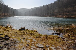
| View from the dam south-southwest over the Schmala reservoir | |||||||||||
|
|||||||||||
|
|
|||||||||||
| Coordinates | 51 ° 19 '19 " N , 8 ° 33' 49" E | ||||||||||
| Data on the structure | |||||||||||
| Construction time: | 1988-1989 | ||||||||||
| Height above valley floor: | approx. 14 m | ||||||||||
| Height above foundation level : | approx. 13 m | ||||||||||
| Height of the structure crown: | approx. 522 m above sea level NHN | ||||||||||
| Crown length: | approx. 100 m | ||||||||||
| Data on the reservoir | |||||||||||
| Altitude (at congestion destination ) | 520.1 m above sea level NHN | ||||||||||
| Water surface | approx. 2.3 ha | ||||||||||
| Reservoir length | approx. 385 m | ||||||||||
| Reservoir width | approx. 80 m | ||||||||||
| Storage space | 0.109 million m³ | ||||||||||
| Catchment area | 4.3 km² | ||||||||||

The Schmala dam , also called Schmalah dam , near Brilon-Wald in the North Rhine-Westphalian Hochsauerlandkreis, is a dam in the Rothaargebirge in the Schmala valley (also called Schmalah and Schellhornbach ).
To the storage system, which of the reservoirs besides those Diemelsee and Twistesee one of three dams in the catchment area of the Diemel and with its jammed waters of industrial water and drinking water of the Briloner urban area serves supply, include in particular the Schmalatalsperre with about 2.3 ha large Schmala reservoir and also two reservoirs (hereinafter referred to as "upper" and "lower pond"). The operators are Stadtwerke Brilon .
geography
location
The Schmala dam is located in the Hochsauerland in the northern part of the Rothaargebirge not far south to southwest and above the village of Brilon-Wald on the Hoppecke . It lies at a maximum of 843.2 m above sea level. NHN high mountains ( Langenberg ; south-south-west above the Schmala spring) framed the valley of the Schmala , which is a south-westerly tributary of the Hoppecke in the catchment area of Diemel and Weser .
Natural allocation
The Schmala dam is located in the natural spatial main unit group Süderbergland (No. 33), in the main unit Rothaargebirge (with Hochsauerland) (333) and in the subunit Hochsauerländer Schluchtgebirge (333.8) in the natural areas Schellhorn and Treiswald (333.82) in the south and Habuch ( 333.83) in the north. The boundary between the two natural spaces is at the upper pond.
Landscape protection areas
The dam Schmala lies in the protected areas Hoppecke Diemel Bergland <Landscape Type A> ( CDDA -No 345,020;. Reported in 1989; 78.03 square kilometers in size) to the east and Olsberg (CDDA No. 345105;. 2004; 79.52 km²) in the West.
Dam
Schmala reservoir
Reservoir
The Schmalastausee ( ⊙ ), also called Schmalahstausee , is the reservoir of the Schmalatalsperre east of the Istenberg ( 728 m ), southwest of the Rehkopf ( 674.7 m ) and northwest of the Großer Kluskopf ( 761 m ). The Schmala flows through it approximately in a south-north direction.
The reservoir is around 2.3 hectares in size and around 900 m in circumference. It is around 385 m long in a south-north direction and a maximum of 80 m wide in a west-east direction. Its water depth is almost 13 m at the deepest point, the water surface is at 520.1 m height when fully dammed . The storage space at the congestion destination is 0.109 million m³. The annual inflow from its 4.3 km² catchment area comprises around 2.2 million m³. While the underwater discharge is at least 5.0 l / s, the highest discharge rate is 42.0 l / s. The reservoir does not have a flood protection area , so that it cannot serve as a flood retention basin in the Weser catchment area .
dam
The dam ( ⊙ ) of the Schmala Reservoir is an approximately 100 m long earth embankment dam about 2.15 km (as the crow flies ) south-southwest of Brilon-Wald and damms the Schmala to the Schmala Reservoir. It has an internal inspection corridor and is 13 m high above the valley floor and 14 m above the foundation floor . The height of the dam crest is around 522 m .
Upper pond
The upper pond ( ⊙ ) is located around 700 m north-northeast of the Schmala Dam and is traversed by the water of a crossover branching off from the Schmala, which is fed to the Schmala below the dam. When it is completely blocked, the water surface is around 495 m above sea level. It is approximately 120 m long in a south-north direction and 30 m wide in a west-east direction.
Lower pond
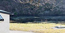
The lower pond ( ⊙ ) is located at the exit of the Schmala valley southwest of a small waterworks and, like the Schmala reservoir, is traversed by the Schmala. Its water surface is around 480 m above sea level when it is fully flooded . It is approximately 100 m long in a west-east direction and 20 m wide in a south-north direction. Its storage space is 4000 m³.
history
The Schmala dam began in 1905 when the city of Brilon began to draw process and drinking water from the Schmala valley. Because the water demand of the inhabitants of Brilon was steadily increasing, a collecting pond (lower pond) with a volume of about 4,000 m³ was built from 1956 to 1958 in the mouth of the Schmala. Because the demand for water continued to increase, the construction of the Schmala dam later became necessary, the design of which was presented in August 1985. Its construction lasted from 1988 to 1989. Commissioning was in 1989.
Traffic and walking
To the east, past the Schmala dam area, a few meters beyond the confluence of the Schmala in the Hoppecke leads the federal road 251 , from which the state road 743 branches off, running west to Elleringhausen and passing through the lower and upper ponds . The Wabern – Brilon Wald railway (Uplandbahn) runs parallel to the B 251 on this side of the Hoppecke, with stops nearby in Willingen (in neighboring North Hesse ) and Brilon-Wald . For example, starting at these traffic axes, you can hike on paths and paths mostly in the forest to the waters of the dam. The Rothaarsteig leads a little west past the dam .
References and comments
- ↑ a b c d e f g h i action plan area ( memento of March 11, 2005 in the Internet Archive ) (originally from StUA Bielefeld), on archive.is
- ↑ a b c d e list of dams in North Rhine-Westphalia , on lua.nrw.de (PDF; 122 KB)
- ↑ a b c d information that can be viewed when creating the article on GeoServer NRW, District Government Cologne, Department GEObasis NRW
- ↑ a b c d e f g h i j k l m n o p Topographical Information Management, Cologne District Government, Department GEObasis NRW ( information )
- ↑ Map services of the Federal Agency for Nature Conservation ( information )
See also
Web links
- Dams directory North Rhine-Westphalia , on lua.nrw.de (PDF; 122 KB)
- Water supply , on stadtwerke-brilon.de
- Action plan area ( Memento from March 11, 2005 in the Internet Archive ) (originally from StUA Bielefeld), on archive.is


