Steens
|
Steens
municipality Hofbieber
Coordinates: 50 ° 34 ′ 6 ″ N , 9 ° 54 ′ 19 ″ E
|
|
|---|---|
| Height : | 600 m |
| Area : | 1.07 km² |
| Residents : | 32 (Dec. 31 1970) |
| Population density : | 30 inhabitants / km² |
| Postal code : | 36415 |
| Area code : | 06657 |
|
Steens,
hamlet of Elters in the municipality of Hofbieber |
|
|
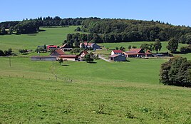
The hamlet of Steens, looking west
|
|
Steens is a m NHN height situated at about 600 hamlets of the district in parent the community Hofbieber in the district of Fulda in Hesse . The formerly independent congregation came to Elters on August 1, 1968 and to Hofbieber on December 31, 1971.
location
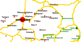
The place is located 15 km southeast of Hünfeld , southeast of Elters, on the southeastern edge of the municipality of Hofbieber on the district road K29 to Dörmbach, which runs from northwest to southeast . Steens is located in the Milseburger Kuppenrhön in the Hessische Rhön Nature Park in a high valley surrounded to the northeast by the 670.3 m high Bomberg, south by the 657.5 m high Oberbernhardser Köpfe and west by the 684.7 m high Hohlstein.
The striking summit of the Milseburg , with the remains of the Milseburg oppidum , the Milseburg castle stable (Liedenküppel) , the Gangolf chapel and the famous Milseburg hut with the Justus Schneider monument, is located about five kilometers south of the hamlet. The high valley around Steens drains south-east to the Dörmbach .
The rare mineral rhoenite is found near the place in nepheline basanite , a volcanic alkali rock .
history
The small hamlet has been documented since 1535. In 1543 four people are named for the hamlet. That remained almost constant until around 1800. In 1787 the hamlet belonged to the Bieberstein office of the prince abbey of Fulda . To this day, Steens has its own trademark . With the Napoleonic Wars from 1803 to 1806 the short-lived Principality of Nassau-Oranien-Fulda came about, was subordinate to the military administration in the Principality of Fulda from 1806 to 1810, came to the Grand Duchy of Frankfurt , Department of Fulda in the District of Bieberstein, from 1810 to 1813 , and became a municipality in 1812 assigned and incorporated by parents. In 1816 it became the Electorate of Hesse . In 1822 the district court of Fulda is responsible.
On July 1, 1850, the hamlet of Elters was spun off again and again independent. In 1867 the place was classified as Prussian and as part of the province of Hessen-Nassau in the administrative district of Kassel in the district of Fulda. In 1885 it was inhabited by 43 people, in 1961 only 32 people were deported. In 1900 Elters and Steens, although still legally independent, were united in a common mayor's district . Elters had to contribute 120 Reichsmarks and Steens 18 Reichsmarks for the annual salary of the joint mayor .
In the course of the beginning of the Hessian regional reform in 1968, the place was again incorporated into Elters as a district and came with this in 1971 in the newly formed large community of Hofbieber, without being considered a district.
The hamlet is located in equal parts southwest and northeast of the county road, divided into four courtyard groups.
The hamlet also includes the Lothar-Mai-Haus about 300 meters south-southeast, 40 meters higher than Steens, located on the edge of the forest and accessible via the street of the same name in Steens. Today it is a mountain hotel. Erected at the beginning of the 1950s as Lothar-Mai-Hütte for the namesake, the then head of the Federal Railway Repair Works in Fulda , it was acquired and expanded in 1991 by the Rabenseifner brothers. In 1999 a hotel complex was added.
Several high-altitude and circular hiking trails through the nature park can be hiked from Steens via a forest parking lot in the direction of Elters. The premium hiking trail of the Hochrhöner leads past the hamlet to the west.
Individual evidence
- ↑ a b c d Steens, District of Fulda. Historical local lexicon for Hesse (as of April 17, 2018). In: Landesgeschichtliches Informationssystem Hessen (LAGIS). Hessian State Office for Historical Cultural Studies (HLGL), accessed on May 23, 2018 .
- ↑ Julius Soellner: About Rhönite, a new änigmatite-like mineral and about the occurrence and distribution of the same in basaltic rocks. In: New Yearbook for Mineralogy, Geology and Palaontology. Volume 24 (1907), p. 519 ( PDF 21.5 MB )
- ↑ List of landmarks in Hessen on geoportal.hessen.de ; accessed on May 23, 2018
- ↑ Elters, District of Fulda. Historical local lexicon for Hesse (as of April 17, 2018). In: Landesgeschichtliches Informationssystem Hessen (LAGIS). Hessian State Office for Historical Cultural Studies (HLGL), accessed on May 23, 2018 .
- ^ Heinrich Reimer: Historisches Ortlexikon für Kurhessen , Marburg 1926, reprint: 1974. S. 454
- ^ Official Journal of the Royal Government of Cassel , Hof- und Waisenhaus-Buchdruckerei Kassel, Kassel 1900, p. 146 f.
- ^ Federal Statistical Office (ed.): Historical municipality directory for the Federal Republic of Germany. Name, border and key number changes in municipalities, counties and administrative districts from May 27, 1970 to December 31, 1982 . W. Kohlhammer GmbH, Stuttgart and Mainz 1983, ISBN 3-17-003263-1 , p. 394 .
- ^ Lothar-Mai-Hütte, Fulda district. Historical local lexicon for Hesse (as of February 7, 2014). In: Landesgeschichtliches Informationssystem Hessen (LAGIS). Hessian State Office for Historical Cultural Studies (HLGL), accessed on May 23, 2018 .
- ^ Lothar-Mai-Haus , private website; accessed on May 23, 2018
- ^ "Lothar-Mai-Haus" in Steens relies on renewable energies on www.fuldainfo.de (online article from November 13, 2014); accessed on May 23, 2018
Web links
- Steens, District of Fulda. Historical local lexicon for Hesse (as of April 17, 2018). In: Landesgeschichtliches Informationssystem Hessen (LAGIS). Hessian State Office for Historical Cultural Studies (HLGL), accessed on May 23, 2018 .
- Internet presence of the community of Hofbieber

